Glenconkeyne
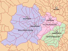
Glenconkeyne (from Irish Gleann Con Cadhain, meaning "valley of Cadhan's hound") is an ancient Irish district in what is now southern County Londonderry, Northern Ireland. Glenconkeyne formed the western portion of the former barony of Loughinsholin, with the ancient districts of Clandonnell, Killetra, and Tomlagh comprising the rest. The area Glenconkeyne covered corresponds to the present-day parishes of Ballynascreen, Desertmartin, and Kilcronaghan.[1][2]
Glenconkeyne has also been recorded in historical sources as Glankonkein and Glanconkeyne.[3]
History
As a result of the dense forest that used to cover Glenconkeyne and Killetra, both formed the most inaccessible part of the whole of Ulster.[1] The Clandeboye O'Neills are recorded as descending from the thick forests of Glenconkeyne from where they would conquer the shattered remnants of the Earldom of Ulster, becoming the principle Gaelic lords of eastern Ulster, with their territory known in English as Clandeboye.[4]
Local legends allegedly state that Glenconkeyne was a gift of Brian Carrach O'Neill to Cadhan O'Henry for defeating a monstrous hound that was terrorising the region, however the scholar John O'Donovan states that across the country many things appeared to be attributed to an areas last lord, as Brian Carrach O'Neill in this case was.[5] Brian Carrach O'Neill would build a residence near the border of the parishes of Kilcronaghan and Ballynascreen, which became known as Dún Tí Bhriain, preserved as the name of the modern townland of Duntibryan.[5]
In the closing stages of Tyrone's Rebellion, Hugh O'Neill, Earl of Tyrone and his supporters withdrew into the Glenconkeyne Woods following the Burning of Dungannon. Tyrone was able to successfully evade capture until he made peace with the Crown.
In 1821, John MacCloskey in his Statistical Reports of Six Derry Parishes, states Tobermore as being the capital settlement of Glenconkeine.[6]
Proportions and townlands

* Cohoire (pale purple)
* Corramony, Glenconkeyne portion (pale brown)
* Corramony, Clandonnell portion (brown)
* Cynah (pale green)
* Moysaden (pale pink)
* Church lands (yellow)
Below is a list of the proportions that Glenconkeyne was divided into as part of the survey of 1609, alongside the townlands which comprised those proportions.[3] These names where recited in the grant of the Charter of Londonderry to The Honourable The Irish Society in 1613.[3] Excluding the church lands, the townlands are thus given in the form provided in the Charter of Londonderry with the modern name if known given afterwards in brackets.[1] Not all townlands recorded survived to the present day. All townlands are of one ballyboe in size unless otherwise stated.[3]
Church lands
These were originally the termon (or erenagh) lands of the parishes that constitute Glenconkeyne. Under the terms of the Plantation of Ulster they were retained by the Bishop of Derry.
- Ballynascreen parish: Cavanreagh; Dunarnon (now part of Owenreagh); Moneyconey; Moyard; Owenreagh; and Tullybrick
- Desertmartin parish: Ballymacpherson; Curr; Knocknagin; and Moydrowne (now called Stranagard)
- Kilcronaghan parish: Granny; Mormeal; Tamnyaskey; and Tullyroan.
Cohoire
Townlands that still exist:
- Ballmelappagh (Labby, Ballynascreen)
- Ballymebracky, one ballyboe and 1/3 of Lislea (Brackaghlislea, Kilcronaghan)
- Ballinehounreagh (Owenreagh, Ballynascreen)
- Ballymadaulaght (Moydamlaght, Ballynascreen)
- Banchran (Bancran Glebe, Ballynascreen)
- Cohoire (Cahore, Ballynascreen)
- Donagilleduff (Doon, Ballynascreen)
- Dromohderigg (Drumderg, Ballynascreen)
- Dromealegan, one third part of the ballyboe (Straw, Ballynascreen)
- Laghtmesky (Strawmore, Ballynascreen)
- Moychellan (Moyheeland, Ballynascreen)
- Moycherrin, one third part of the ballyboe (Moykeeran, Ballynascreen)
- Tonnagh (Tonaght, Ballynascreen)
Townlands that can't be identified and may no longer exist:
- Ballydomedam
- Ballyroghan, one third part of the ballyboe
- Dromegane
- Monygroyau
- Moylehaghi
- Rahmeigh
- Tristernan, one third part of the ballyboe
Corramony
This proportion is split between territories of Glenconkeyne and Clandonnell. The following townlands are within Glenconkeyne:
- Balmenoure, one and half ballyboes (Ballynure, Ballynascreen)
- Clony (Cloane, Ballynascreen)
- Corramony (Carnamoney, Ballynascreen)
- Culnesellah (Coolnasillagh, Ballynascreen)
- Derrynard (Derrynoyd, Ballynascreen)
- Domituibrian (Duntibryan, Ballynascreen)
- Dromard, 1/3 of a ballyboe (Drumard, Ballynascreen)
- Dromballyagan (Drumballyhagan and Drumballyhagan Clarke, Kilcronaghan)
- Mollyshanare, two ballyboes (Moneyshanere, Kilcronaghan)
- Monagogy, 1/3 of a ballyboe (possibly Moneyguiggy, Ballynascreen)
- Moybegg (Moybeg Kirley, Kilcronaghan)
The rest of the townlands in this proportion are in Clandonnell:
- Ballyknock-Icleny (Ballyknock, Killelagh)
- Ballmabrcky (Bracaghreilly, Maghera)
- Carely (Kirley, Maghera)
- Falaglona (Fallagloon, Maghera)
- Fillaley, one and a half ballyboes (Fallylea, Killelagh)
- Namroah (Drumconready, Maghera)
Cynah
Townlands that still exist:
- Ballmegallan (Cullion, Desertmartin)
- Ballyngam (Ballynagown, Desertmartin)
- Ballytannylour (Killyboggin, Desertmartin)
- Consaran (Coolsaragh, Kilcronaghan)
- Crannagh (Cranny, Desertmartin)
- Cynagh (Keenaght, Kilcronaghan)
- Derryneskellan (Durnascallon, Desertmartin)
- Gortihorky (Gortahurk, Kilcronaghan)
- Gortmeren (Gortanewry, Desertmartin)
- Langhell (Longfield, Desertmartin), one balliboe and a half
- Lickmahary (Lecumpher, Desertmartin)
- Lislea (Brackaghlislea, Kilcronaghan), 2/3 of a balliboe
- Lysanny (Annagh, Desertmartin)
- Momisholm (Moneysterlin, Desertmartin)
- Rosiare (Roshure, Desertmartin)
- Torrigan (Tirgan, Desertmartin)
- Vrackah (Brackagh Slieve Gallion, Desertmartin)
Townlands that no longer exist:
- Drombally (Drumbally Hill), 1/2 a balliboe, the other half of which is within the proportion of Moysaden
Moysaden
Townlands that still exist:
- Ballmeclom (Clooney, Kilcronaghan)
- Cloghom (Cloughfin, Kilcronaghan), one balliboe and a half
- Cowlanamone (Killynumber, Kilcronaghan)
- Culemoire (Calmore, Kilcronaghan)
- Dromaraghy (Drumrainey)
- Dromsanna (Drumsamney, Kilcronaghan)
- Dromore (Dromore, Desertmartin)
- Gortitawry (Gortamney, Kilcronaghan)
- Killitomny (Killytoney, Kilcronaghan)
- Lawny (Luney, Desertmartin)
- Moysaden (Moyesset, Kilcronaghan)
- Tobarmore (Tobermore, Kilcronaghan)
Townlands that can't be identified and may no longer exist:
- Conlaire
- Donnagraven (Grenan, later known as Fortwilliam, now part of Tobermore, Kilcronaghan)
- Drombally (Drumbally Hill), 1/2 a balliboe, the other half of which is in the proportion of Cynah
- Kilnacring
- Tonnaghvore
References
<div class="reflist columns references-column-width" style="-moz-column-width: [1] [2] [5] [6] [4] [3]; -webkit-column-width: [1] [2] [5] [6] [4] [3]; column-width: [1] [2] [5] [6] [4] [3]; list-style-type: decimal;">
- 1 2 3 4 5 6 Toner, Gregory, Place-names of Northern Ireland – Volume Five, County Londonderry I, The Moyola Valley, page 233. The Institute of Irish Studies – Queens University Belfast, 1996. ISBN 0-85389-613-5
- 1 2 3 4 Notes on the Place Names of the Parishes and Townlands of the County of Londonderry, 1925, Alfred Moore Munn, Clerk of the Crown and Peace of the City and County of Londonderry
- 1 2 3 4 5 6 7 The Conquest of Ireland – County Londonderry Lands and Families in Northern Ireland, page 388, Rev. George Hill
- 1 2 3 4 Bardon, Jonathan, A History of Ulster, page 45. The Black Syaff Press, 2005. ISBN 0-85640-764-X
- 1 2 3 4 5 Mr. John O'Donovans Letters from County Londonderry (1834)
- 1 2 3 4 Statistical Reports of Six Derry Parishes 1821, John MacCloskey