Gortahurk, Kilcronaghan civil parish
| Gortahurk | |
|---|---|
| Irish transcription(s) | |
| • Derivation: | Gort an Choirce |
| • Meaning: | "Field of the oats" |
 | |
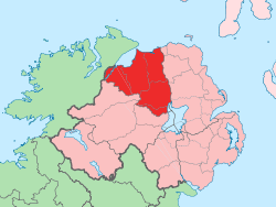
 Gortahurk Gortahurk shown within Northern Ireland | |
| Coordinates: 54°45′54″N 6°44′28″W / 54.765°N 6.741°WCoordinates: 54°45′54″N 6°44′28″W / 54.765°N 6.741°W | |
| Country | Northern Ireland |
| County | County Londonderry |
| Barony | Loughinsholin |
| Civil parish | Kilcronaghan |
| Plantation grant | Drapers Company |
| First recorded | 1609 |
| Government | |
| • Council | Magherafelt District Council |
| • Ward | Tobermore |
| Area[1] | |
| • Total | 351.93 ha (869.63 acres) |
| Irish grid ref | H8191 |
Gortahurk (locally [ˌɡɔrtəˈhɔrk] and [ˌɡɔrtneˈhərk], from Irish Gort an Choirce, meaning "field of the oats"[2]) is a townland lying within the civil parish of Kilcronaghan, County Londonderry, Northern Ireland. It lies on the extreme south-west of the parish on the boundary with the parish of Ballynascreen. It is bounded by the townlands of Brackaghlislea, Coolsaragh, Drumard, Keenaght, Letteran, Straw Mountain, Tintagh, and Tullyroan. It was apportioned to the Drapers company.[3]
The townland currently lies within Tobermore electoral ward of Magherafelt District Council, however in 1901 and 1926 it was part of Iniscarn District Electoral Division as part of the Draperstown dispensery (registrar's) district of Magherafelt Rural District.[4][5] It was also part of the historic barony of Loughinsholin.[3]
Etymology
Gortahurk derives its name from the Irish Gort an Choirce meaning "field of the oats". Two of the earliest recordings of this townland however—GortyIchorchy (1609) and Gort Okorte (1613)—suggest that the scribe felt that the final element of the name Gortahurk was a surname. This is testified by the use of the capital I in GortyIchorchy and the capital O in Okorte, both of which represent the Irish surname prefix Ui. Despite this no suitable surname is attested to in any of the major works on Irish surnames.[2]
History
|
|
| ||||||||||||||||||||||||||||||||||||||||||||||||||||||
See also
References
- ↑ Northern Ireland Environment Agency. "NIEA Map Viewer". Retrieved 27 January 2012.
- 1 2 3 Toner, Gregory: Place-Names of Northern Ireland, page 123-124. Queen's University of Belfast, 1996, ISBN 0-85389-613-5
- 1 2 Notes on the Place Names of the Parishes and Townlands of the County of Londonderry, 1925, Alfred Moore Munn, Clerk of the Crown and Peace of the City and County of Londonderry
- 1 2 3 4 HistPop; Area, houses, and population, Vol. III [Part 2], Ireland, 1901 Page 34
- 1 2 3 4 HistPop; County and County Borough of Londonderry, 1926, page 24
- 1 2 3 4 5 6 HistPop; Area, population and number of houses, Vol. III, Ireland, 1881, page 698
- ↑ HistPop; County of Londonderry, 1851, page 241
- ↑ Place Names NI - Gortahurk