Frankland Group National Park
| Frankland Group National Park Queensland | |
|---|---|
|
IUCN category II (national park) | |
 Frankland Group National Park | |
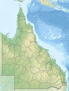
| Coordinates | 17°09′49″S 146°00′42″E / 17.16361°S 146.01167°ECoordinates: 17°09′49″S 146°00′42″E / 17.16361°S 146.01167°E |
| Established | 1994 |
| Area | 77 ha (190.3 acres) |
| Managing authorities | Queensland Parks and Wildlife Service |
| Website | Frankland Group National Park |
| See also | Protected areas of Queensland |
Frankland Group is a national park in Queensland, Australia, 1353 km northwest of Brisbane. The five continental islands of the Franklin group are High, Normanby, Mabel, Round and Russel isles, which lie about 10 km offshore, and are about 45 km south east of Cairns.[1] They are the traditional home of the Mandingalbay Yidinji, and the Gungandji Aboriginal peoples.[2]
See also
References
- ↑ "About The Franklands". The State of Queensland (Department of National Parks, Recreation, Sport and Racing). Retrieved 21 December 2012.
- ↑ "Frankland Group National Park". The State of Queensland (Department of National Parks, Recreation, Sport and Racing). Retrieved 21 December 2012.
This article is issued from Wikipedia - version of the 7/27/2016. The text is available under the Creative Commons Attribution/Share Alike but additional terms may apply for the media files.