Point Hicks
| Point Hicks (Tolywiarar) | |
| Cape Everard | |
| Headland | |
| Name origin: In honour of Lieutenant Zachary Hickes | |
| Country | Australia |
|---|---|
| State | Victoria |
| Regions | South East Corner (IBRA), East Gippsland |
| Local government area | Shire of East Gippsland |
| Building | Point Hicks Lighthouse |
| Coordinates | 37°48′11″S 149°16′32″E / 37.80306°S 149.27556°ECoordinates: 37°48′11″S 149°16′32″E / 37.80306°S 149.27556°E |
| Discovered by | James Cook |
| - date | 19 April 1770 |
| National parks | Croajingolong NP, Point Hicks Marine NP |
|
Location of Point Hicks in Victoria | |
| [1] | |
Point Hicks or Tolywiarar (formerly called Cape Everard), is a coastal headland in the East Gippsland region of Victoria, Australia, located within the Croajingolong National Park. The point is marked by the Point Hicks Lighthouse that faces the Tasman Sea.
Etymology
The traditional custodians of the land surrounding Point Hicks are the Australian Aboriginal Bidhawal and Gunaikurnai peoples who called the point Tolywiarar.[1][3]
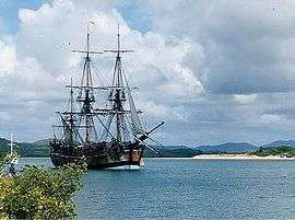
The coastal area near Point Hicks lies on the north-eastern coast of Victoria, Australia. It was the first land ever sighted and recorded by Europeans on the East Coast of Australia (then known as New Holland). The sighting took place at first light [4] on Thursday 20 April 1770 by Lieutenant Zachary Hicks aboard James Cook's Endeavour. This was the first of Cook's three voyages to the Pacific, and the sighting came after 19 days' westward sailing following the Endeavour leaving New Zealand on its homeward journey. Cook recorded in his ship's Journal that it was Hicks who first saw land,[5] and that later that day he (Cook) named a far-off point after Hicks: "I have named it Point Hicks, because Lieutenant Hicks was the first who discover'd this Land."[6] This was confirmed by Aaron Arrowsmith's 1798 Chart of the Pacific Ocean, clearly showing Cook's Point Hicks. (Hicks did not survive the return voyage but died on board soon after the Endeavour left the Cape.)
George Bass sailed past the area at the end of 1797, in an open whale-boat and was unable to identify the point.[7] Although Matthew Flinders sailed past the area in 1798-99 and again in 1802-03, the coastal area near Point Hicks was always out of Flinders’ visual range. Therefore, it did not appear on any of Matthew Flinders published charts. The name Point Hicks was still being used on maps[8] up until 1840, before being replaced and renamed Cape Everard. The first use of the new name has been attributed to hydrographer John Lort Stokes who surveyed the coast in the Beagle in 1843. It is presumed he named it after fellow naval officer James Everard Home.[2] Stokes' maps don't record the name, but many secondary sources attribute its introduction to him. The first known chart showing Cape Everard was published by surveyor George Douglas Smythe, made in 1852 and published in 1853. If he coined the name, then according to one theory he may have been referring to William Everard, commissioner of crown lands (though no record of that Everard has been found). The name Cape Everard was then adopted from 1853 up until the early 1900s, until more historical information became readily available.
The location of landfall sited from the Endeavour has been mired in considerable controversy for over a century. Cook estimated the coordinates of his Point Hicks (from a great distance) to be located at 38°0′S 148°53′E / 38.000°S 148.883°E, a location in the sea over 60 km to the South West. Though measuring longitude in Cook's time was problematic in the absence of reliable ship chronometers, Cook and his astronomer's measurements of latitude were usually very accurate. Nevertheless, the latitude of 38 degrees S placed the point more than 20 km out to sea from the East-West running coastline. It is likely that the reckoning was an error, that a cloudbank was mistaken for land, and that the true location of landfall by the Endeavour lies somewhat to the East of Cape Everard.[9]
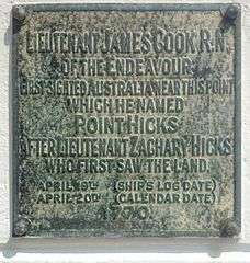
Despite the adopted use of the name Point Everard to designate the promontory, Cook's original name of Point Hicks was recorded on an obelisk-shaped monument erected by the Australian Government on the site in 1924.[10] [2]:n30 The inscription on the landward side of the monument reads:[11]
"Lieutenant James Cook, R.N. Of the Endeavour, First Sighted Australia Near This Point, Which He Named Point Hicks After Lieutenant Zachary Hicks Who First Saw the Land. April 19th (Ship's Log Date). April 20th (Calendar Date). 1770."On the seaward side of the monument is a plaque listing the "Ship's Company of H.M. Bark Endeavour April 20th 1770".[2]:n30
Note that the plaque shows the "Calendar Date" as April 20th compared to the Ship's Log Date of April 19th. In keeping with the usual custom, Cook recorded entries in his Journal according to Ship Time, where the day runs from midday of the day before the date of the entry to midday of the date of the entry. Thus, Cook's entry for the sighting of land by Hicks is in the early morning of the entry dated "THURSDAY, 19th" April, which is also the morning of 19th April by the civil reckoning. However, Cook did not, and could not, take into consideration the date line, which when later invoked made the morning of Thursday 19th April into the morning of Thursday 20th April.[6]
In the 1930s, the Australian business man and philanthropist Russell Grimwade commissioned stone to be quarried from Cape Everard and shipped to Great Ayton in Yorkshire. It was used to create a replica monument with an identical plaque placed at the site of the Cook family home, following Grimwade having the home dismantled and removed to Fitzroy Gardens, Melbourne in 1934.
Cook's name, Point Hicks, was officially established as the name of the cape as part of the bicentenary of Cook's 1770 voyage along the East Coast of Australia. Victorian Premier Henry Bolte proclaimed the new name in a ceremony at the point on 20 April 1970.
See also
References
- 1 2 "Point Hicks: 17439". Vicnames. Government of Victoria. 2 May 1966. Retrieved 9 January 2014.
- 1 2 3 4 Haldane, Robert (2001). "A Beacon on the Wilderness Coast: The Story of Point Hicks (Cape Everard)". Gippsland Heritage Journal. Retrieved 27 February 2015.
- ↑ "Point Hicks Marine National Park". Parks Victoria. Government of Victoria. Retrieved 10 January 2014.
- ↑ Moorehead, Alan (1968) "The Fatal Impact - An Account of the Invasion of the South Pacific 1767-1840", Penguin Books Australia Ltd., Victoria, Australia, p. 130
- ↑ "The Land of New Holland" from Parkinson's manuscript Journal dated 29/4/1770
- 1 2 Cook, James (1 May 2005). Wharton, W. J. L, ed. Captain Cook's Journal During His First Voyage Round the World Made in H. M. Bark "Endeavour", 1768-71 (e-book). Project Gutenberg.
- ↑ Flinders, Matthew (17 July 2004). A Voyage to Terra Australis (e-book). Volume I. Project Gutenberg.
- ↑ Map by The Society for the diffusion of useful knowledge published in 1840
- ↑ Trevor Lipscombe, Cook's Point Hicks: Error that just won't go away, Captain Cook Society, http://www.captaincooksociety.com/home/detail/cook-s-point-hicks-error-that-just-won-t-go-away
- ↑ Lipscombe, Trevor (August 2014). "Hydrographers v Historians — the truth about Point Hicks" (PDF). Map Matters. Australasian Hydrographic Society (24): 4–8. Retrieved 27 February 2015.
- ↑ "COOK'S VOYAGE.". The Argus. Melbourne: National Library of Australia. 6 November 1924. p. 17. Retrieved 27 September 2013.
External links
- Point Hicks lighthouse at SeaSide Lights
- Point Hicks page at Geoscience Australia