Emőd
| Emőd | ||
|---|---|---|
_2.jpg) | ||
| ||
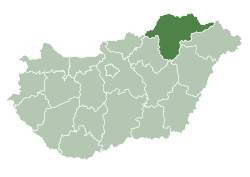
 Emőd Location of Emőd | ||
| Coordinates: 47°56′00″N 20°49′01″E / 47.93333°N 20.81690°ECoordinates: 47°56′00″N 20°49′01″E / 47.93333°N 20.81690°E | ||
| Country |
| |
| County | Borsod-Abaúj-Zemplén | |
| Area | ||
| • Total | 49.42 km2 (19.08 sq mi) | |
| Population (2001) | ||
| • Total | 5,474 | |
| • Density | 110.76/km2 (286.9/sq mi) | |
| Time zone | CET (UTC+1) | |
| • Summer (DST) | CEST (UTC+2) | |
| Postal code | 3432 | |
| Area code(s) | 46 | |
Emőd is a small town in Borsod-Abaúj-Zemplén county, Northern Hungary, 25 kilometers from county capital Miskolc.
History
The area has been inhabited since the Conquest of Hungary. Its name comes from an old Hungarian personal name. The town was first mentioned by Anonymus. Emőd has been a wine-growing area since the 14th century. In 1882 it was burnt down, but was rebuilt later. In 1872 it was downgraded to a village, and got town status back only on August 19, 2001.
External links
This article is issued from Wikipedia - version of the 8/18/2015. The text is available under the Creative Commons Attribution/Share Alike but additional terms may apply for the media files.