Aunsby and Dembleby
| Aunsby and Dembleby | |
 |
|
| Population | 125 (2001) |
|---|---|
| OS grid reference | TF041382 |
| – London | 100 mi (160 km) S |
| District | North Kesteven |
| Shire county | Lincolnshire |
| Region | East Midlands |
| Country | England |
| Sovereign state | United Kingdom |
| Post town | Sleaford |
| Postcode district | NG34 |
| Police | Lincolnshire |
| Fire | Lincolnshire |
| Ambulance | East Midlands |
| EU Parliament | East Midlands |
| UK Parliament | Sleaford and North Hykeham (UK Parliament constituency) |
|
|
Aunsby and Dembleby is a civil parish in the North Kesteven district of Lincolnshire, England. According to the 2001 Census it had a population of 125. The parish includes Aunsby and Dembleby, which were separate parishes until 1931, and the hamlet of Scott Willoughby.
The three ecclesiastical parishes are still administered separately, although all are part of the South Lafford Group of the Lafford Deanery, Diocese of Lincoln. The incumbent is the Rev'd Charles Robertson.[1][2][3]
Aunsby
52°56′13″N 0°26′48″W / 52.93694°N 0.44667°W
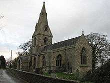
Aunsby lies just north and west off the point where the A15 crosses the A52. Its church, dedicated to St Thomas Of Canterbury, is a mixture of Norman and Perpendicular styles of architecture. It was repaired and rebuilt in 1861.[4]
In the Domesday survey the village is called "Ounesbi".
The ecclesiastical parish is Aunsby[1]
Dembleby
52°55′42″N 0°27′21″W / 52.92833°N 0.45583°W

Dembleby appears in the Domesday survey three times, as "Denbelbi", "Delbebi" and "Dembelbi". The parish was in the ancient Aswardhurn Wapentake.
St Lucia's Church is a foundation of unknown age, originally built in Early English style. The old church was taken down in 1867. The new church was built upon a better site in Norman style. The vestry in the current church was re-erected from the old church.[5]
The new church was consecrated in January, 1868
The ecclesiastical parish is Dembleby[2]
To the west is the woodland of Dembleby Thorns.[6]
Scott Willoughby
52°55′31″N 0°26′02″W / 52.92528°N 0.43389°W

Scott Willoughby is a small hamlet situated less than 1 mile (1.6 km) south-east from Aunsby. It has the smallest church that remains in use in the county. It was built in 1826, although there may have been an earlier church on the site.[7]
The ecclesiastical parish is Scott Willoughby[3]
The population of Scott Willoughby has rapidly declined over the past 200 years, with few houses remaining in the hamlet, despite this the post-box is still used.
Lost villages
Several abandoned medieval villages are known in the wider area.
- Dembeleby is a Shrunken Village, considerably larger in Medieval times.[5]
- Scott Willoughby is a Shrunken Village, or more properly a modern hamlet named for a nearby Medieval site[8]
- Crofton is mentioned in documents of the 12th century, and the name is associated with two modern houses to the North West of the parish.[9][10]52°56′51″N 0°25′55″W / 52.94750°N 0.43194°W
Businesses
All employment in the parish is agricultural.
References
- 1 2 "Aunsby D C C".
- 1 2 "Dembleby D C C".
- 1 2 "Scot Willoughby D C C".
- ↑ Historic England. "Church of St Thomas a Becket (348686)". PastScape. Retrieved 23 December 2013.
- 1 2 Historic England. "Dembelby (348675)". PastScape. Retrieved 23 December 2013.
- ↑ Bourne & Heckington: Billingborough & Morton (Map). 1:25000. OS Explorer Map. OSGB. 3 April 2006. § 278. ISBN 978-0-319-23811-0. Dembleby Thorns TF025383
- ↑ Historic England. "Church of St Andrew (348602)". PastScape. Retrieved 23 December 2013.
- ↑ Historic England. "Scott Willoughby (348624)". PastScape. Retrieved 23 December 2013.
- ↑ Historic England. "Crofton (348963)". PastScape. Retrieved 23 December 2013.
- ↑ Bourne & Heckington: Billingborough & Morton (Map). 1:25000. OS Explorer Map. OSGB. 3 April 2006. § 278. ISBN 978-0-319-23811-0. Crofton TF055402
External links
| Wikimedia Commons has media related to Aunsby and Dembleby. |
- Aunsby, Lincolnshire - St Thomas a Becket Church
- Lafford Deanery
- Aunsby in the Domesday Book
- Dembleby in the Domesday Book
- [Scott] Willoughby in the Domesday Book
England Portal | |
| Unitary authorities | |
| Boroughs or districts | |
| Major settlements |
|
| Topics | |