Connecticut River
| Connecticut River (Kwenitegok[1]) | |
 | |
| Country | United States |
|---|---|
| States | Connecticut, Massachusetts, Vermont, New Hampshire |
| Tributaries | |
| - left | Chicopee River |
| - right | White River |
| Cities | Springfield, Massachusetts, Hartford, Connecticut |
| Source | Fourth Connecticut Lake |
| - elevation | 2,660 ft (811 m) |
| - coordinates | 45°14′53″N 71°12′51″W / 45.24806°N 71.21417°W |
| Mouth | Long Island Sound |
| - location | Old Saybrook, Connecticut and Old Lyme, Connecticut, Connecticut[2] |
| - coordinates | 41°16′20″N 72°20′03″W / 41.27222°N 72.33417°WCoordinates: 41°16′20″N 72°20′03″W / 41.27222°N 72.33417°W |
| Length | 410 mi (660 km) |
| Basin | 11,250 sq mi (29,137 km2) |
| Discharge | for Thompsonville, Connecticut |
| - average | 17,070 cu ft/s (483 m3/s) |
| - max | 282,000 cu ft/s (7,985 m3/s) |
| - min | 968 cu ft/s (27 m3/s) |
| Discharge elsewhere (average) | |
| - West Lebanon, New Hampshire | 6,600 cu ft/s (187 m3/s) |
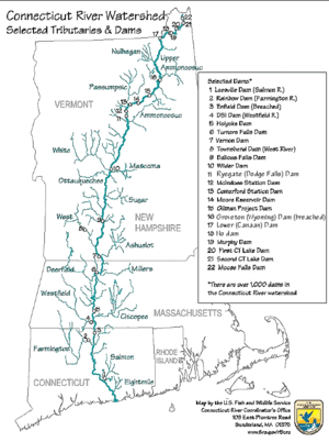 River map, with major tributaries and selected dams.
| |
The Connecticut River is the longest river in the New England region of the United States. Flowing roughly southward for 406.12 miles (653.59 km) through four U.S. states, the Connecticut rises at the U.S. border with Quebec, Canada, and discharges at Long Island Sound.[3] Its watershed encompasses five U.S. states and one Canadian province – 11,260 square miles (29,200 km2) – via 148 tributaries, 38 of which are major rivers.[4] Discharging at 19,600 cubic feet (560 m3) per second, the Connecticut produces 70% of Long Island Sound's fresh water.[4][5]
The Connecticut River Valley is home to some of the northeastern United States' most productive farmland, as well as a metropolitan region of approximately 2 million people surrounding Springfield, Massachusetts, and the state of Connecticut's capital, Hartford.[6]
Etymology
The word "Connecticut" is a French corruption of the Mohegan word quinetucket, which means "beside the long, tidal river".[7] The word "Connecticut" came into existence during the early 1600s, describing the river, which was also called simply "The Great River".[8]
History


Pre-1614–1637: Native populations
Prior to Dutch exploration beginning in 1614, numerous native tribes lived throughout the fertile Connecticut River valley. Information concerning how these tribes lived and interacted stems mostly from English accounts written during the 1630s.[9]
Natives of the Lower Valley
In the southernmost region of the Connecticut River valley, the Pequots dominated a territory stretching roughly from the river's mouth (at modern-day Old Saybrook) northward to just below the Big Bend (at modern-day Middletown). By employing highly organized, aggressive tactics – alternately warring with, subjugating, and making alliances with less-centralized, predominantly agricultural tribes like the Western Niantic and Tunxis – the Pequots fended off invasions by their rivals, the Mohegans.[10]
At the Connecticut's Big Bend (at modern-day Middletown), the Mattabesset (Tunxis) tribe takes its name from the place where its sachems ruled, in a village sandwiched between the territories of the aggressive Pequots to the south and Mohegans to the north.[11]
Natives of the Middle Valley
Due north, where modern-day Hartford and its suburbs sit – on the ancient floodplain of the glacial Lake Hitchcock – the Mohegans dominated the region, particularly after allying themselves with the English against the Pequots during the Pequot War of 1637.[12] Often portrayed as the "good Indians" in colonial accounts of the Pequot War, the Mohegans' culture bore a striking cultural resemblance to that of the Pequots, as they had 'split off' from the Pequots and become their rivals sometime prior to the Europeans' explorations of the area.[12]
North of the Enfield Falls, on the fertile stretch of hills and meadows surrounding modern-day Springfield, the peaceful, agricultural Pocomtuc tribe lived in unfortified villages alongside the Connecticut. En route from coastal Boston to Albany on the ancient Bay Path, where the Connecticut meets the western Westfield River and eastern Chicopee River, sat the Pocomtuc village of Agawam (meaning "landing place" or "place for unloading canoes,") which eventually became Springfield.[13] The Pocomtuc villagers at Agawam helped Puritan explorers settle this advantageous site, and – as opposed to tribes further north and south along the Connecticut – remained friendly with them for decades, helping them to develop Springfield.[14][15] The region stretching from Springfield northward to the modern-day New Hampshire and Vermont state borders – with its soil enhanced by sedimentary deposits from the ancient Lake Hitchcock – fostered many peaceful, agricultural Pocomtuc and Nipmuc settlements. Occasionally, these villages endured invasions from more aggressive confederated tribes living in modern-day New York, such as the Mohawk, Mahican and Iroquois tribes.[14][15]
Natives of the Upper Valley
With a territory stretching roughly from the Massachusetts border with Vermont and New Hampshire, northward to the rise of the White Mountains in New Hampshire, the Pennacook tribe mediated many early disagreements between colonists and other Native tribes, particularly those that lived closer to the Atlantic coast.[16]
In the northernmost reaches of the Connecticut River Valley, the Western Abenaki (Sokoki) tribe lived in the Green Mountains region of Vermont, but wintered as far south as the Northfield, Massachusetts area. They later merged with members of other Algonquin tribes displaced by the wars and famines that accompanied the European settling of the Connecticut River Valley.[17]
1614–1632: Dutch exploration and settlement
In 1614, Dutch explorer Adriaen Block became the first European explorer to chart the Connecticut River, sailing as far north as Enfield Rapids.[18] In charting the Connecticut, Bloeck called it the "Fresh River", and claimed it for the Netherlands as the northeastern border of the New Netherland colony. In 1623, Dutch traders constructed a fortified trading post at the site of modern Hartford, Connecticut, calling it the Fort Huys de Hoop ("Fort House of Hope") on the plain that became modern Hartford.[19]
1632–1636: Puritan settlement
Less than a decade later, four separate Puritan-led groups settled the fertile Connecticut River Valley. In the process, they founded the two large cities that continue to dominate the Connecticut River Valley today – Hartford (est. 1635) and Springfield (est. 1636).
Displeased, for various reasons, with their own settlement along the New England coast, the first group of pioneers that settled the Connecticut River Valley left the Plymouth Colony in 1632, and ultimately founded the village of Matianuck (modern Windsor, Connecticut) – several miles north of the Dutch fort at modern Hartford.
In 1633, a group left the Massachusetts Bay Colony from Watertown, seeking a site where they could practice their religion more strictly. With this in mind, they founded Wethersfield, Connecticut, in 1633 – several miles south of the Dutch fort at modern Hartford.
.jpg)
In 1635, the charismatic Reverend Thomas Hooker led settlers from the Massachusetts Bay Colony settlement at Cambridge, Massachusetts – where Hooker had feuded with the more conservative Reverend John Cotton – to the site in Connecticut of the Dutch "Fort House of Hope", where Hooker founded "Newtowne" (modern Hartford).[19] Shortly after Hooker's arrival, Newtowne annexed Matianuck (modern Windsor), based on laws supposedly articulated in Connecticut's settlement charter, the Warwick Patent of 1631. The "patent," however, had been physically lost, and the annexation was almost certainly illegal.[20]
The fourth English settlement along the Connecticut came out of a 1635 scouting party commissioned by William Pynchon. Iconoclastic by Massachusetts Bay Colony standards, Pynchon commissioned scouts to find the most advantageous site on the Connecticut River for the dual purposes of conducting commerce and agriculture, hoping to found a city there. His scouts located the Pocumtuc village of Agawam, where the ancient Bay Path trade route crossed the Connecticut at two of its major tributaries – the Chicopee River to the east and Westfield River to the west. Located just north of the Connecticut's first unnavigable waterfall, Enfield Falls, Pynchon correctly surmised that traders utilizing any of these major roads or waterways would have to dock and change ships at his site, thereby granting the settlement a commercial advantage.[21] Initially named Agawam Plantation and allied with the southern settlements that would become the state of Connecticut, Pynchon's settlement switched allegiances in 1641 and was renamed Springfield in honor of Pynchon's native town in England.[21]
Of these settlements, Hartford and Springfield quickly emerged as powers. In 1641, Springfield splintered off from the Hartford-based Connecticut Colony, instead allying itself with the Boston-based Massachusetts Bay Colony. For decades, Springfield remained the Massachusetts Bay Colony's westernmost settlement, on the northern border of the Connecticut Colony. By 1654 however, the success of these English settlements rendered the Dutch position on the Connecticut untenable. A treaty relocated the boundary between the Connecticut Colony and New Netherland Colony westward, near present-day Greenwich. The treaty allowed the Dutch to maintain their trading post at Foot Huys de Hoop, which they did until the 1664 British takeover of New Netherland.
Border disputes
The Connecticut Valley's central location, fertile soil, and abundant natural resources made it the target of centuries of border disputes. Beginning with Springfield's defection from the Connecticut Colony in 1641, which brought the Massachusetts Bay Colony to the river; to the conflicting royal treaties of 1764, which sparked the river's east-siders to unite with Ethan Allen and the west-siders against New York and the British; to the 1783 Treaty of Paris, which created a disputed U.S. international border with Canada from the Connecticut's "northernmost headwaters"; to the 1935 U.S. Supreme Court case which settled a contentious boundary dispute between Vermont and New Hampshire – the Connecticut's history is characterized by both political intrigue and technological innovation.[22]
Springfield allies with the Massachusetts Bay Colony
During 1640 and 1641, two political controversies took place that altered the political boundaries of the Lower Connecticut River region, preventing it from administration by a single political body.
During the 1630s, the Connecticut Colony administered Springfield, in addition to Hartford, Wethersfield, and Windsor; however, by 1640, Springfield's advantageous geography enabled it to become the Connecticut Colony's most commercially prosperous settlement. During the spring of 1640, the Connecticut Colony endured a crippling grain shortage, which caused many cattle to die of starvation. The grain shortage became a matter of survival for the Connecticut Colony, but due to its prosperity, not for Springfield.[21]
In response to the shortage, leading citizens of Wethersfield and Hartford gave power to Springfield's founder, Pynchon, to purchase corn for all of the Connecticut Colony's settlements from the Pocumtuc. Colony leaders authorized Pynchon to offer large sums of money – far above market prices – to the natives; however, during negotiations, Pynchon became convinced that the natives refused to sell at even "reasonable" prices, and thus he refused to buy the corn altogether. Explaining his decision, Pynchon opined that it was best not to broadcast the Connecticut Colonists' weaknesses to the natives, whom he believed might capitalize on it; likewise, he aimed to keep market values – and trade with the natives – steady in the future.[21]
Furious with Pynchon's seeming willingness to further imperil the starving settlements, leading citizens of Hartford – with Windsor's and Wethersfield's consent – commissioned Captain John Mason, who had fought against Native Americans in the Pequot War, to travel to Springfield with "money in one hand and a sword in the other" to make a deal with the Native Americans, and also to rebuke Pynchon.[21] On reaching Springfield, Mason threatened the natives with war if they did not sell their corn at 'reasonable' prices. The natives capitulated, and ultimately sold the Connecticut Colonists' corn; however, Mason's violent approach roused distrust among the (theretofore friendly) Pocumtuc natives. Mason also upbraided Pynchon in public.[21] This incident, which arose partly from differences regarding how to treat Native Americans – Pynchon had achieved mutual benefits via capitalism with the Pocumtucs, whereas Mason had used force during the 1637 Pequot War – nevertheless caused Springfield's settlers to rally around the humiliated Pynchon, and led to the settlement severing ties with the Connecticut Colony.[21]
As this controversy was heating up, the relatively distant, coastal Massachusetts Bay Colony saw an opportunity to gain a foothold along the fertile Connecticut. In 1640, Boston asserted a claim to jurisdiction over lands surrounding the Connecticut River; however, Springfield remained politically independent until tensions with the Connecticut Colony were exacerbated by a final confrontation later that year.[21]
Since its founding, Hartford kept a fort at the mouth of the Connecticut River – at present-day Old Saybrook – for protection against the Pequots, Wampanoags, Mohegans, and the New Netherland Colony. After Springfield broke ties with the Connecticut Colony, the remaining Connecticut settlements demanded that Springfield's ships pay tolls when passing the mouth of the Connecticut River. Springfield's ships refused to pay this tax without representation at Connecticut's fort. Hartford, in turn, refused to grant Springfield representation. In response, the Massachusetts Bay Colony solidified its friendship with Springfield by levying a toll on Connecticut Colony ships entering Boston Harbor. Connecticut, which was then largely dependent on sea trade with Boston, permanently dropped its tax on Springfield. Following this bit of gamesmanship, Springfield allied with Boston, drawing the first state border across the Connecticut.[21]
New Hampshire, Vermont, and New York border disputes
The Fort at Number 4, which is now Charlestown, New Hampshire, was the northernmost English settlement on the Connecticut River until the end of the French and Indian War in 1763. Prior to that, Abenaki natives resisted British attempts at colonization; however, following the British victory over the allied French and Indian forces, the British began settling north of modern-day Brattleboro, Vermont.[23] Settlement of the Upper Connecticut region increased quickly, with population assessments of 36,000 by 1790.[23]
The area that is now Vermont was claimed by both New Hampshire and New York, and was settled primarily through the issuance of land grants by New Hampshire Governor Benning Wentworth beginning in the 1740s.[24] New York protested these grants, and in 1764 King George III decided that the border between the provinces should be the western bank of the Connecticut River.[25] The residents of the disputed area, notably Ethan Allen and the Green Mountain Boys, actively resisted attempts by New York to exercise its authority over the area, which resulted first in the establishment of the independent Vermont Republic in 1777,[26] and its eventual accession in 1791 to the United States as the fourteenth state.[27] Boundary disputes between Vermont and New Hampshire lasted for nearly 150 years thereafter, finally settling in 1934, when the U.S. Supreme Court re-affirmed King George's boundary as the ordinary low-water mark on the Vermont shore. In some places, the state line is now inundated by the impoundments of dams built after this time.[28]
The Treaty of Paris and the 19th century
The Treaty of Paris (1783) that ended the American Revolutionary War created a new international border between New Hampshire and what was to become the Province of Canada at "northwesternmost headwaters of the Connecticut". Several streams fit this description, and thus a boundary dispute led to the short-lived Indian Stream Republic, which existed from 1832 to 1835.

The broad, fertile Connecticut River Valley attracted agricultural settlers and colonial traders to Hartford, Springfield, and the surrounding region; later, during the 19th century, the high volume and numerous falls of the river led to the rise of industry. During the Industrial Revolution, the cities of Springfield and Hartford in particular became centers of innovation and "intense and concentrated prosperity."[29]
In 1829 the Enfield Falls Canal was opened to circumvent shallows by the Connecticut's first major falls, the Enfield Falls. The locks built for this canal gave their name to the town of Windsor Locks, Connecticut.[30] The Connecticut River Valley – in particular, the cities of Springfield and Hartford – functioned as America's hub of technical innovation into the 20th century, and thus attracted numerous railroad lines. The proliferation of the railroads in Springfield and Hartford greatly decreased the economic importance of the Connecticut River. From the late 1800s until today, it has functioned largely as a center of wildlife and recreation.[31]
Log drives and the early 20th century

Starting about 1865,[32] the river was used for massive logging drives from Third Connecticut Lake to initially water powered sawmills near Enfield Falls. Trees cut adjacent to tributary streams including Perry Stream and Indian Stream in Pittsburg, New Hampshire, Halls Stream on the Quebec–New Hampshire border, Simms Stream, the Mohawk River, and the Nulhegan River basin in Essex County, Vermont, would be flushed into the main river by the release of water impounded behind splash dams. Several log drivers died trying to move logs through Perry Falls in Pittsburg. Teams of men would wait at Canaan, Vermont, to protect the bridges from log jams. Men guided logs through a 400-foot (120 m) drop along the length of Fifteen-Mile Falls[32] (now submerged under Moore and Comerford reservoirs), and through Logan's Rips at Fitzdale, Mulligan's Lower Pitch, and Seven Islands. The White River from Vermont and Ammonoosuc River from New Hampshire brought more logs into the Connecticut. A log boom was built between Wells River, Vermont, and Woodsville, New Hampshire, to hold the logs briefly and release them gradually to avoid jams in the Ox Bow. Men detailed to this work utilized Woodsville's saloons and red-light district.[33] Some of the logs were destined for mills in Wilder and Bellows Falls, Vermont, while others were sluiced over the Bellows Falls dam. North Walpole, New Hampshire, contained twelve to eighteen saloons, patronized by the log drivers.[34] Mount Tom was the landmark the log drivers used to gauge the distance to the final mills near Holyoke, Massachusetts.[35] These spring drives were stopped after 1915, when pleasure boat owners complained about the hazards to navigation.[36] The final drive included 500 workers controlling 65 million feet of logs.[32] A final pulp drive consisted of 100,000 cords of four-foot logs in 1918. This was to take advantage of the wartime demand.[32]
The flood of 1936
In March 1936, due to a winter with heavy snowfall, an early spring thaw and torrential rains, the Connecticut River flooded, overflowing its banks, destroying numerous bridges and isolating hundreds of people who had to be rescued by boat.
The dam at Vernon, Vermont, was topped by 19 feet (5.8 m). Sandbagging by the National Guard and local volunteers helped prevent the dam's powerhouse from being overwhelmed, despite blocks of ice breaking through the upstream walls.[37]
In Northampton, Massachusetts, looting during the flood became a problem, causing the mayor of the city to deputize citizen patrols to protect flooded areas. Over 3,000 refugees from the area were housed in Amherst College and the Massachusetts State Agricultural College (now UMass Amherst).
Unprecedented accumulated ice jams compounded the problems created by the flood, diverting water into unusual channels and damming the river, raising water levels even further. When the jam at Hadley, Massachusetts, gave way, the water crest overflowed the dam at Holyoke, overwhelming the sandbagging there. The village of South Hadley Falls was essentially destroyed, and the southern parts of Holyoke were severely damaged, with 500 refugees.

In Springfield, Massachusetts, 5 sq mi (13 km2), and 18 miles (29 km) of streets, were flooded, and 20,000 people lost their homes. The city lost power, and nighttime looting caused the police to issue a "shoot on sight" edict; 800 National Guard troops were brought in to help maintain order. Rescue efforts using a flotilla of boats saved people trapped in upper stories of buildings, bringing them to local fraternal lodges, schools, churches and monasteries for lodging, medical care, and food. The American Red Cross and local, state and Federal agencies, including the WPA and the CCC, contributed aid and manpower to the effort. Flooding of roads isolated the city for a time. When the water receded, it left behind silt-caused mud which in places was 3 feet (1 m) thick; the recovery effort in Springfield, at the height of the American Great Depression, took approximately a decade.
Overall, the flood caused 171 deaths and US$500 million (US$8,500,000,000 with inflation[38]) in damages. Across the northeast, over 430,000 people were made homeless or destitute by flooding that year.[39]
The Connecticut River Flood Control Compact between the states of Connecticut, Massachusetts, New Hampshire, and Vermont was established in 1953 to help prevent serious flooding.[40]
1936–present: Water supply
The creation of the Quabbin Reservoir in the 1930s diverted the Swift River, which feeds the Chicopee River, a tributary of the Connecticut. This resulted in an unsuccessful lawsuit by the state of Connecticut against the diversion of its riparian waters.[41]
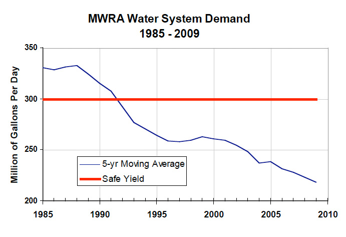
Demand for drinking water in eastern Massachusetts passed the sustainable supply from the existing system in 1969. Diverting water from the Connecticut River was considered several times,[42] but in 1986 the Massachusetts Water Resources Authority instead undertook a campaign of water conservation. Demand was reduced to sustainable levels by 1989, reaching approximately a 25% margin of safety by 2009.[43]
Course
By far the largest river ecosystem in New England, the Connecticut River watershed spans five of the six New England states – New Hampshire, Vermont, Massachusetts, Connecticut, as well as small portions of Maine and the Canadian province of Quebec.[4][28][44]
The Upper Connecticut River: New Hampshire and Vermont
_at_high_flow_2-26-2016.JPG)
The Connecticut River rises from the Fourth Connecticut Lake, a small pond that sits 300 yards (270 m) south of the U.S. national border with Chartierville, Quebec, Canada, in the town of Pittsburg, New Hampshire, United States. Beginning at an elevation of 2,670 feet (810 m) above sea level, the Connecticut River flows through the remaining Connecticut Lakes and Lake Francis – for 14-mile (23 km), all within the town of Pittsburg – and then widens as it delineates 255-mile (410 km) of the border between New Hampshire and Vermont.[44] The Connecticut drops more than 2,480 feet (760 m) in elevation as it winds south to the border of Massachusetts, at which point it sits 190 feet (58 m) above sea level.[28][45]
The region along the river upstream and downstream from Lebanon, New Hampshire and White River Junction, Vermont, is known locally as the "Upper Valley". The exact definition of the region varies, but it generally is considered to extend south to Windsor, Vermont, and Cornish, New Hampshire, and north to Bradford, Vermont, and Piermont, New Hampshire.[46]
The Middle Connecticut River: Massachusetts through central Connecticut
Following the most recent ice age, the Middle Connecticut River Valley sat at the bottom of Lake Hitchcock. Its lush greenery and rich, almost rockless soil comes from the ancient lake's sedimentary deposits.[47] In the Middle Connecticut region, the river reaches its maximum depth – 130 feet (40 m) – at Gill, Massachusetts, around the French King Bridge, and its maximum width – 2,100 feet (640 m) – at Longmeadow, directly across from the Six Flags New England amusement park.[28][48] The Connecticut's largest falls – South Hadley Falls – features a vertical drop of 58 feet (18 m).[4] Lush green forests and agricultural hamlets dot this middle portion of the Connecticut River; however, the region is best known for its numerous college towns, such as Northampton, South Hadley, and Amherst, as well as the river's most populous city, Springfield. The city sits atop bluffs beside the Connecticut's confluence with two major tributaries, the Chicopee River to the east and Westfield River to the west.[49]
The Connecticut River is influenced by the tides as far north as Enfield Rapids in Windsor Locks, Connecticut, approximately 58 miles (93 km) north of the river's mouth. Two million residents live in the densely populated Hartford-Springfield region, which stretches roughly between the college towns of Amherst, Massachusetts, and Middletown, Connecticut. Hartford, the Connecticut River's second largest city and only state capital, is located at the southern end of this region on an ancient floodplain that stretches to Middletown.
The Lower Connecticut River: Southern Connecticut through Long Island Sound
15 miles (24 km) south of Hartford, at Middletown, the Lower Connecticut River section begins with a narrowing of the river, and then a sharp turn southeast. Throughout southern Connecticut, the Connecticut passes through a thinly populated, hilly, wooded region before again widening and discharging into Long Island Sound between Old Saybrook and Old Lyme. Due to the presence of large, shifting sandbars at its mouth, the Connecticut is the only major river in the Northeastern United States without a port at its mouth.[50]
Mouth and tidelands
The Connecticut River carries a heavy amount of silt, especially during the spring snow melt, from as far north as Quebec. This heavy silt concentration manifests in a large sandbar near the Connecticut's mouth, which has, historically, provided a formidable obstacle to navigation. Due to the difficulty it presents to ships, the Connecticut is one of the few major rivers in the United States without a major city at its mouth. The Connecticut's major cities – Hartford and Springfield – lie 45 and 69 miles (70 and 110 km) upriver, respectively.

The Nature Conservancy named the Connecticut River's tidelands one of the Western Hemisphere's "40 Last Great Places", while the Ramsar Convention on Wetlands listed its estuary and tidal wetlands complex as one of 1,759 wetlands of international importance.[51]
In 1997, the Connecticut River was designated one of only 14 American Heritage Rivers, which recognized its "distinctive natural, economic, agricultural, scenic, historic, cultural and recreational qualities." In May 2012, the Connecticut River was designated America's first National Blueway, in recognition of the restoration and preservation efforts on the river.[6]
Dams
The Connecticut River's flow is slowed by main stem dams, which create a series of slow-flowing basins from Lake Francis Dam in Pittsburg, New Hampshire, to the Holyoke Dam at South Hadley Falls in Massachusetts.[4] Among the most extensively dammed rivers in the United States, the Connecticut may soon flow at a more natural pace, according to scientists at the University of Massachusetts at Amherst, who have devised a computer that – "in an effort to balance human and natural needs" – coordinates the holding and releasing of water between the river's 54 largest dams.[52]
Tributaries
The Connecticut River watershed encompasses 11,260 square miles (29,200 km2), connecting 148 tributaries, including 38 major rivers and numerous lakes and ponds.[6] Major tributaries include (from north to south) the Passumpsic, Ammonoosuc, White, Black, West, Ashuelot, Millers, Deerfield, Chicopee, Westfield, and Farmington rivers. The Swift River, a tributary of the Chicopee, has been dammed and largely replaced by the Quabbin Reservoir which provides water to the Massachusetts Water Resources Authority district in eastern Massachusetts, including Boston and its metropolitan area.
Fish

There are several species of anadromous and catadromous fish, including brook trout, winter flounder, blueback herring, alewife, rainbow trout, large brown trout, American shad (Alosa sapidissima), hickory shad, smallmouth bass, Atlantic sturgeon, striped bass (Morone saxatilis), carp, catfish, American eel, sea lamprey, and endangered shortnose sturgeon and dwarf wedgemussels.[53] Additionally, the United States Fish and Wildlife Service has repopulated the river with another species of migratory fish, the Atlantic salmon, which for more than 200 years had been extinct from the river due to damming.[53] Several fish ladders and fish elevators have been built to allow fish to resume their natural migration upriver each spring.
Much of the beginning of the river's course in the town of Pittsburg is occupied by the Connecticut Lakes, which contain lake trout and landlocked salmon. Landlocked salmon make their way into the river during spring spawning runs of bait fish and during their fall spawn. The river has fly-fishing-only regulations on 5 miles (8 km) of river. Most of the river from Lake Francis south is open to lure and bait as well. Two tail-water dams provide cold river water for miles downstream, making for bountiful summer fishing on the Connecticut.
After the first major dam was built near Turners Falls, Massachusetts, thirteen additional dams have ended the Connecticut River's great anadromous fish runs. Fish ladders constructed since the first fish passage in 1980 at Turners Falls, have enabled migrating fish to return to some of their former spawning grounds. In addition to dams, warm water discharges between 1978 and 1992 from Vermont Yankee Nuclear Power Plant in Vernon,Vermont released water up to 105 °F (41 °C) degrees and the thermal plume reached 55 miles (89 km) downstream to Holyoke. This thermal pollution appears to be associated with an 80% decline in American shad fish numbers from 1992 to 2005 at Holyoke dam. This decline may have been exacerbated by over-fishing in the mid-Atlantic and predation from resurging striped bass populations. The nuclear plant was closed at the end of 2014 but the 2015 shad run at Vernon numbered only 42,000 shad.[1]
There are 12 species of freshwater mussels.[54] Of those, 11 occur in the mainstem of the Connecticut, all but the brook floater, which is found only in small streams and rivers. Species diversity is higher in the southern part of the watershed (Connecticut and Massachusetts) than in the northern part (Vermont and New Hampshire), largely due to differences in stream gradient and substrate. Eight of the 12 species in the watershed are listed as endangered, threatened, or of Special Concern in one or more of the states in the watershed.[54]
Economy
Boating
The mouth of the river up to Essex is thought to be one of the busiest stretches of waterway in Connecticut. Some local police departments and the state Environmental Conservation Police patrol the area a few times a week. Some towns keep boats available if needed.[55] In Massachusetts, the most active stretch of the Connecticut River is centered on the Oxbow, 14 miles (23 km) north of Springfield in the college town of Northampton.[56]
Primitive camping is available along much of the river, for non-motorized boats, via the Connecticut River Paddlers' Trail. The Paddlers' Trail currently includes campsites on over 300 miles (480 km) of the river.[57]
Pollution and cleanup

The Water Quality Act of 1965 had a major impact on controlling water pollution in the Connecticut River and its tributaries.
Since then, the river has been restored from Class D to Class B (fishable and swimmable). Many towns along the Lower Connecticut River have enacted a cap on further development along the banks, so that no buildings may be constructed except on existing foundations. Currently, a website provides water quality reports twice a week, indicating whether various portions of the river are safe for swimming, boating and fishing.[58][59]
Lists
Populated places
Tributaries


.JPG)
Listed from south to north by location of mouth:
- Black Hall River (Old Lyme, CT)
- Falls River (Essex, CT)
- Eightmile River (Hamburg, CT)
- Deep River (Deep River, CT)
- Salmon River (Moodus, CT)
- Mattabesset River (Middletown, CT)
- Hockanum River (East Hartford and Hartford, CT)
- Park River (Hartford, CT)
- Farmington River (Windsor, CT)
- Scantic River (South Windsor, CT)
- Westfield River (West Springfield and Springfield, MA)
- Mill River (Springfield, MA)
- Chicopee River (Chicopee and Springfield, MA)
- Manhan River (The Oxbow of Northampton, MA)
- Mill River (Northampton, MA)
- Fort River (Hadley, MA)
- Mill River (Hatfield, MA)
- Mill River (Amherst, MA)
- Sawmill River (Montague, MA)
- Deerfield River (Deerfield and Greenfield, MA)
- Fall River (Greenfield and Gill, MA)
- Millers River (Millers Falls, MA)
- Ashuelot River (Hinsdale, NH)
- Whetstone Brook (Brattleboro, VT)
- West River (Brattleboro, VT)
- Partridge Brook (Westmoreland, NH)
- Cold River (Walpole, NH)
- Saxtons River (Westminster, VT)
- Williams River (Rockingham, VT)
- Black River (Springfield, VT)
- Little Sugar River (Charlestown, NH)
- Sugar River (Claremont, NH)
- Blow-me-down Brook (Cornish, NH)
- Ottauquechee River (Hartland, VT)
- Mascoma River (West Lebanon, NH)
- White River (White River Junction, VT)
- Mink Brook (Hanover, NH)
- Ompompanoosuc River (Norwich, VT)
- Waits River (Bradford, VT)
- Oliverian Brook (Haverhill, NH)
- Wells River (Wells River, VT)
- Ammonoosuc River (Woodsville, NH)
- Stevens River (Barnet, VT)
- Passumpsic River (Barnet, VT)
- Johns River (Dalton, NH)
- Israel River (Lancaster, NH)
- Upper Ammonoosuc River (Northumberland, NH)
- Paul Stream (Brunswick, VT)
- Nulhegan River (Bloomfield, VT)
- Simms Stream (Columbia, NH)
- Mohawk River (Colebrook, NH)
- Halls Stream (Beecher Falls, VT)
- Indian Stream (Pittsburg, NH)
- Perry Stream (Pittsburg, NH)
Crossings
The Connecticut River is a barrier to travel between western and eastern New England. Several major transportation corridors cross the river including Amtrak's Northeast Corridor, Interstate 95 (Connecticut Turnpike), Interstate 90 (Massachusetts Turnpike), Interstate 89, Interstate 93, and Interstate 84. In addition, Interstate 91, whose route largely follows the river north-south, crosses it twice – once in Connecticut and once in Massachusetts.
Sites of interest
- Connecticut River Museum in Essex, Connecticut
- Lyman and Merrie Wood Museum of Springfield History in Springfield, Massachusetts
See also
- Equivalent Lands
- The Great Attack, the burning of American ships on the Connecticut River at Essex in 1814
- History of Connecticut
- Lake Connecticut, post-glacial predecessor to Lake Hitchcock
- Lake Hitchcock, post-glacial predecessor to the Connecticut River
- List of rivers of Connecticut
- List of rivers of Massachusetts
- List of rivers of New Hampshire
- List of rivers of Vermont
Notes
- 1 2 Michael J. Caduto (November 30, 2015). "With Cooler Water, Better Prospects for Shad Migration?". Northern Woodlands Magazine. Retrieved August 9, 2016.
- ↑ U.S. Geological Survey Geographic Names Information System: Connecticut River
- ↑ Linda Brughelli (October 28, 2014). "Essex - Connecticut". BBC Local: Essex. Retrieved August 9, 2016.
- 1 2 3 4 5 "Watershed Facts". Connecticut River Watershed Council. Retrieved August 9, 2016.
- ↑ "Event: Source To Sea Cleanup To Benefit 410 Miles of Connecticut River — Courant.com – CT Environmental Headlines". Environmentalheadlines.com. Retrieved 25 November 2014.
- 1 2 3 "About the River". Connecticutriver.us. Retrieved August 9, 2016.
- ↑ "Connecticut State Name Origin". Statesymbolsusa.org. Retrieved 25 November 2014.
- ↑ Alberta Eiseman (August 30, 1998). "THEATER; The Industrialization of the Great River, New England's Longest". The New York Times. Retrieved August 9, 2016.
- ↑ "Pequot History". Dickshovel.com. July 15, 1997. Retrieved August 9, 2016.
- ↑ "1637 – The Pequot War". The Society of Colonial Wars in the State of Connecticut. Retrieved August 9, 2016.
- ↑ "Mattabesic History". Dickshovel.com. November 15, 1997. Retrieved August 9, 2016.
- 1 2 "Mohegan History". Dickshovel.com. July 14, 1997. Retrieved August 9, 2016.
- ↑ "Full text of "Indian place names of New England"". Archive.org. Retrieved 25 November 2014.
- 1 2 "We Have A New Lodge!!!!!". Pocumtuc Lodge – Western Massachusetts Council, Boy Scouts of America. October 9, 2008. Retrieved August 9, 2016.
- 1 2 "Pocumtuc History". Dickshovel.com. Retrieved August 9, 2016.
- ↑ "Pennacook History". Dickshovel.com. Retrieved August 9, 2016.
- ↑ "Abenaki". Dickshovel.com. Retrieved 25 November 2014.
- ↑ Al Braden (March 1, 2010). The Connecticut River: A Photographic Journey Into the Heart of New England. Wesleyan University Press. Retrieved August 9, 2016.
- 1 2 "House of Hope". A Tour of New England: Connecticut. New Netherland Institute. Retrieved August 9, 2016.
- ↑ "The Warwick Patent". Colonial Records & Topics. CT State Library. Retrieved August 9, 2016.
- 1 2 3 4 5 6 7 8 9 Barrows, Charles Henry (1911). The history of Springfield in Massachusetts for the young: being also in some part the history of other towns and cities in the county of Hampden. The Connecticut Valley Historical Society. pp. 46–48. US 13459.5.7.
- ↑ "No border dispute here: Vt., NH reaffirm boundary". The Big Story. March 14, 2012. Retrieved August 9, 2016.
- 1 2 "Why did settlers come to New Hampshire and Vermont, and where did they come from?". Teaching Early Settlement. Flowofhistory.org (Southeast Vermont Community Learning Collaborative). Retrieved August 9, 2016.
- ↑ Wardner, p. 13.
- ↑ Wardner, p. 41
- ↑ Wardner, p. 443
- ↑ Van de Water, Frederic. The Reluctant Republic, New York: John Day, 1941. p. 337
- 1 2 3 4 "Fast Facts". Connecticut River Joint Commissions. Retrieved August 9, 2016.
- ↑ Archived December 3, 2008, at the Wayback Machine.
- ↑ Archived September 26, 2006, at the Wayback Machine.
- ↑ "Environment & Geography: Written in the Rocks and Sand". Connecticut River Byway Council. Retrieved August 9, 2016.
- 1 2 3 4 Pike, Helen (April 2013). "Spring Log Drives Through Fifteen-Mile Falls". Vermont's Northland Journal. 12 (1): 20–21.
- ↑ Holbrook p.68
- ↑ Holbrook p.70
- ↑ Holbrook, Stewart H. (1961). Yankee Loggers. International Paper Company. pp. 63–70.
- ↑ Wheeler, Scott (September 2002). The History of Logging in Vermont's Northeast Kingdom. The Kingdom Historical.
- ↑ Klekowski, Ed; ilda, Elizabeth; Klekowski, Libby (2003). The Great Flood of 1936: The Connecticut River Story (DVD). Springfield, Massachusetts: WGBY. Event occurs at 02:10. OCLC 58055715. Retrieved 16 November 2011.
- ↑ Federal Reserve Bank of Minneapolis Community Development Project. "Consumer Price Index (estimate) 1800–". Federal Reserve Bank of Minneapolis. Retrieved October 21, 2016.
- ↑ Klelowski, Ed. The Great Flood of 1936: The Connecticut River Valley Story WGBY (2003)
- ↑ "Connecticut River Flood Control Compact" (PDF). US Government Printing Office. June 6, 1953. Retrieved August 9, 2016.
- ↑ U.S. Supreme Court, Connecticut v. Massachusetts, 282 U.S. 660 (1931)
- ↑ "CRWC History". Connecticut River Watershed Council. Retrieved August 9, 2016.
- ↑ "MWRA Water System Demand, 1985–2009". Massachusetts Water Resources Authority. Retrieved August 9, 2016.
- 1 2 "Designated Rivers: The Connecticut River". New Hampshire Department of Environmental Services. Retrieved August 9, 2016.
- ↑ "State officials to perambulate the border between N.H. and Vermont (symbolically, that is)". The Telegraph. May 10, 2012. Retrieved August 9, 2016.
- ↑ "Upper Valley Bi-State Regional Chamber of Commerce". Upper Valley Chamber of Commerce. Retrieved July 15, 2014.
- ↑ Richard D. Little. "Geological History of the Connecticut River Valley". Earth View LLC. Retrieved August 9, 2016.
- ↑ Klekowski, Ed (June 2–4, 2000). "Stop 1-7B: Abyssal Depths in Turner's Falls Area, French King Bridge" (PDF). North Eastern Friends of the Pleistocene Field Conference. Retrieved August 9, 2016.
- ↑ Susan McGowan. "The Landscape in the Colonial Period". Americancenturies.mass.edu. Retrieved 25 November 2014.
- ↑ "Type 6 Conservation Site – Connecticut River Estuary" (PDF). Oldsaybrookct.org. Retrieved 25 November 2014.
- ↑ "Connecticut River Tidelands". Yankee Magazine. Retrieved 25 November 2014.
- ↑ Sam Wotipka (October 10, 2013). "Connecticut River May Soon Flow Freely Again". Scope. MIT Graduate Program in Science Writing. Retrieved August 9, 2016.
- 1 2 Northeast Region Web Development Group. "Fisheries Program - Northeast Region – U.S. Fish & Wildlife Service". Fws.gov. Retrieved 25 November 2014.
- 1 2 Nedeau, Ethan Jay (2008). "Freshwater Mussels and the Connecticut River Watershed" (PDF). Connecticut River Watershed Council, Greenfield, MA. Retrieved August 9, 2016.
- ↑ Kaplan, Thomas (August 30, 2007). "River Watchers, Tackling Speeders and Thin Budgets.". The New York Times. Retrieved August 9, 2016.
- ↑ "Welcome". Oxbow Marina. Retrieved August 9, 2016.
- ↑ "Connecticut River Paddlers' Trail". connecticutriverpaddlerstrail.org. Retrieved August 9, 2016.
- ↑ "News and Information from Northampton, MA by the Daily Hampshire Gazette – GazetteNet.com". Gazettenet.com. Retrieved 25 November 2014.
- ↑ "Water Quality Monitoring". Tri-State Connecticut River Targeted Watershed Initiative. Center for Educational Software Development – University of Massachusetts Amherst. Retrieved August 9, 2016.
Further reading
- Bacon, Edwin M. (1906). The Connecticut River and the Valley of the Connecticut: Three Hundred and Fifty Miles from Mountain to Sea. New York: G.P. Putnam's Sons. LCC F12.C7 B2.
- Braden, Al (2009). The Connecticut River: A Photographic Journey into the Heart of New England. Middletown CT: Wesleyan University Press. ISBN 978-0-8195-6895-3.
- Delany, Edmund Thomas (1983). The Connecticut River: New England's Historic Waterway. The Globe Pequot Press. ISBN 978-0-87106-980-1.
- Hard, Walter R. (1947). The Connecticut (Rivers of America). New York, Toronto: Rinehart & Company, Inc. ISBN 0-932691-27-7. LCC F12.C7 H3.
- Roth, Randolph A. (2003). The Democratic Dilemma: Religion, Reform, and the Social Order in the Connecticut River Valley of Vermont, 1791–1850. Cambridge Mass.: Cambridge University Press. ISBN 978-0-521-31773-3.
- Wardner, Henry Steele (1927). The Birthplace of Vermont: A history of Windsor to 1781. New York: Scribner's. ASIN B00086X8BY. LCCN 27014536.
External links
| Wikimedia Commons has media related to Connecticut River. |
 "Connecticut River". Encyclopædia Britannica. 6 (11th ed.). 1911.
- Connecticut River Watershed Council
- Connecticut River Valley Flood Control Commission
- Connecticut River Museum
- Connecticut Riverfest
- Upper Valley Trails Alliance
- Connecticut River Joint Commissions
- Tri-state Connecticut River Watershed Initiative
- "Connecticut, a river of the United States". Collier's New Encyclopedia. 1921.
| Rivers | ||
|---|---|---|