French and Indian War
| French and Indian War | |||||||||
|---|---|---|---|---|---|---|---|---|---|
| Part of the Seven Years' War | |||||||||
 The war theatre | |||||||||
| |||||||||
| Belligerents | |||||||||
|
Catawba Cherokee (before 1758) |
Algonquin Lenape Ojibwa Ottawa Shawnee Wyandot | ||||||||
| Commanders and leaders | |||||||||
|
Jeffery Amherst Edward Braddock † James Wolfe † Earl of Loudoun James Abercrombie Edward Boscawen George Washington John Forbes George Monro |
Louis-Joseph de Montcalm † Marquis de Vaudreuil Baron Dieskau (POW) François-Marie de Lignery † Chevalier de Lévis (POW) Joseph de Jumonville † Marquis Duquesne Daniel Lienard de Beaujeu † | ||||||||
| Strength | |||||||||
| 42,000 regulars and militia (peak strength, 1758)[1] | 10,000 regulars (troupes de la terre and troupes de la marine, peak strength, 1757)[2] | ||||||||
The French and Indian War (1754–1763) comprised the North American theater of the worldwide Seven Years' War of 1756-1763. The war pitted the colonies of British America against those of New France, with both sides supported by military units from their parent countries of Great Britain and France, as well as by Native American allies. At the start of the war, the French North American colonies had a population of roughly 60,000 European settlers, compared with 2 million in the British North American colonies.[3] The outnumbered French particularly depended on the Indians. Following months of localised conflict, the metropole nations declared war on each other in 1756, escalating the war from a regional affair into an intercontinental conflict.
The name French and Indian War, used mainly in the United States, refers to the two main enemies of the British colonists: the royal French forces and the various indigenous forces allied with them. British and European historians use the term the Seven Years' War, as do English speaking Canadians.[4] French Canadians call it La guerre de la Conquête (the War of the Conquest)[5][6] or (rarely) the Fourth Intercolonial War.[7]
Fighting took place primarily along the frontiers between New France and the British colonies, from Virginia in the south to Newfoundland in the north. It began with a dispute over control of the confluence of the Allegheny and Monongahela rivers, called the Forks of the Ohio, and the site of the French Fort Duquesne (within present-day Pittsburgh, Pennsylvania). The dispute erupted into violence in the Battle of Jumonville Glen in May 1754, during which Virginia militiamen under the command of 22-year-old George Washington ambushed a French patrol.
In 1755, six colonial governors in North America met with General Edward Braddock, the newly arrived British Army commander, and planned a four-way attack on the French. None succeeded, and the main effort by Braddock proved a disaster; he lost the Battle of the Monongahela on July 9, 1755 and died a few days later. British operations in 1755, 1756 and 1757 in the frontier areas of Pennsylvania and New York all failed, due to a combination of poor management, internal divisions, effective Canadian scouts, French regular forces, and Indian warrior allies. In 1755, the British captured Fort Beauséjour on the border separating Nova Scotia from Acadia; soon afterwards they ordered the expulsion of the Acadians (1755-1764). Orders for the deportation were given by William Shirley, Commander-in-Chief, North America, without direction from Great Britain. The Acadians, both those captured in arms and those who had sworn the loyalty oath to His Britannic Majesty, were expelled. Native Americans were likewise driven off their land to make way for settlers from New England.[8]
After the disastrous 1757 British campaigns (resulting in a failed expedition against Louisbourg and the Siege of Fort William Henry, which was followed by Indian torture and massacres of British victims), the British government fell. William Pitt came to power and significantly increased British military resources in the colonies at a time when France was unwilling to risk large convoys to aid the limited forces it had in New France. France concentrated its forces against Prussia and its allies in the European theatre of the war. Between 1758 and 1760, the British military launched a campaign to capture the Colony of Canada. They succeeded in capturing territory in surrounding colonies and ultimately the city of Quebec (1759). Though the British later lost the Battle of Sainte-Foy west of Quebec (1760), the French ceded Canada in accordance with the Treaty of Paris (1763).
The outcome was one of the most significant developments in a century of Anglo-French conflict. France ceded its territory east of the Mississippi to Great Britain. It ceded French Louisiana west of the Mississippi River (including New Orleans) to its ally Spain, in compensation for Spain's loss to Britain of Florida (Spain had ceded Florida to Britain in exchange for the return of Havana, Cuba). France's colonial presence north of the Caribbean was reduced to the islands of Saint Pierre and Miquelon, confirming Great Britain's position as the dominant colonial power in eastern North America.
The origin of the name
The conflict is known by multiple names. In British America, wars were often named after the sitting British monarch, such as King William's War or Queen Anne's War. As there had already been a King George's War in the 1740s, British colonists named the second war in King George's reign after their opponents, and it became known as the French and Indian War.[9] This traditional name continues as the standard in the United States, but it obscures the fact that Indians fought on both sides of the conflict, and that this was part of the Seven Years' War, a much larger conflict between France and Great Britain.[10] American historians generally use the traditional name or sometimes the Seven Years' War. Other, less frequently used names for the war include the Fourth Intercolonial War and the Great War for the Empire.[9]
In Europe, the North American theater of the Seven Years' War usually is not given a separate name. The entire international conflict is known as the Seven Years' War. "Seven Years" refers to events in Europe, from the official declaration of war in 1756 to the signing of the peace treaty in 1763. These dates do not correspond with the fighting on mainland North America, where the fighting between the two colonial powers was largely concluded in six years, from the Battle of Jumonville Glen in 1754 to the capture of Montreal in 1760.[9]
In Canada, both French-speaking and English-speaking Canadians refer to both the European and North American conflicts as the Seven Years' War (Guerre de Sept Ans).[11][12] French Canadians also use the term "War of Conquest" (Guerre de la Conquête), since it is the war in which Canada was conquered by the British and became part of the British Empire.
North America in the 1750s
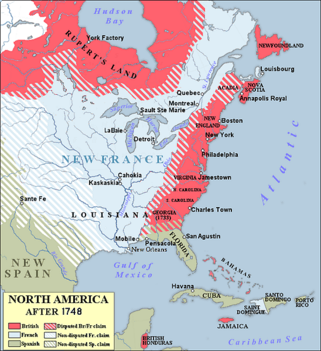
At this time, North America east of the Mississippi River was largely claimed by either Great Britain or France. Large areas had no settlements by Europeans.
The French population numbered about 75,000 and was heavily concentrated along the St. Lawrence River valley, with some also in Acadia (present-day New Brunswick and parts of Nova Scotia, including Île Royale (present-day Cape Breton Island)). Fewer lived in New Orleans, Biloxi, Mississippi, Mobile, Alabama and small settlements in the Illinois Country, hugging the east side of the Mississippi River and its tributaries. French fur traders and trappers traveled throughout the St. Lawrence and Mississippi watersheds, did business with local tribes, and often married Indian women.[13] Traders married daughters of chiefs, creating high-ranking unions.
British settlers outnumbered the French 20 to 1[14] with a population of about 1.5 million ranged along the eastern coast of the continent, from Nova Scotia and Newfoundland in the north, to Georgia in the south.[15] Many of the older colonies had land claims that extended arbitrarily far to the west, as the extent of the continent was unknown at the time their provincial charters were granted. While their population centers were along the coast, the settlements were growing into the interior. Nova Scotia, which had been captured from France in 1713, still had a significant French-speaking population. Britain also claimed Rupert's Land, where the Hudson's Bay Company traded for furs with local tribes.

In between the French and the British, large areas were dominated by native tribes. To the north, the Mi'kmaq and the Abenaki were engaged in Father Le Loutre's War and still held sway in parts of Nova Scotia, Acadia, and the eastern portions of the province of Canada, as well as much of present-day Maine.[16] The Iroquois Confederation dominated much of present-day Upstate New York and the Ohio Country, although the latter also included Algonquian-speaking populations of Delaware and Shawnee, as well as Iroquoian-speaking Mingo. These tribes were formally under Iroquois rule, and were limited by them in authority to make agreements.[17]
Further south the Southeast interior was dominated by Siouan-speaking Catawba, Muskogee-speaking Creek and Choctaw, and the Iroquoian-speaking Cherokee tribes.[18] When war broke out, the French used their trading connections to recruit fighters from tribes in western portions of the Great Lakes region (an area not directly subject to the conflict between the French and British), including the Huron, Mississauga, Ojibwa, Winnebago, and Potawatomi. The British were supported in the war by the Iroquois Six Nations, and also by the Cherokee – until differences sparked the Anglo-Cherokee War in 1758. In 1758 the Pennsylvania government successfully negotiated the Treaty of Easton, in which a number of tribes in the Ohio Country promised neutrality in exchange for land concessions and other considerations. Most of the other northern tribes sided with the French, their primary trading partner and supplier of arms. The Creek and Cherokee were subject to diplomatic efforts by both the French and British to gain either their support or neutrality in the conflict. It was not uncommon for small bands to participate on the "other side" of the conflict from formally negotiated agreements, as most tribes were decentralized and bands made their own decisions about warfare.
By this time, in eastern North America Spain claimed only the province of Florida; it controlled Cuba and other territories in the West Indies that became military objectives in the Seven Years' War. Florida's European population was a few hundred, concentrated in St. Augustine and Pensacola.

At the start of the war, no French regular army troops were stationed in North America, and few British troops. New France was defended by about 3,000 troupes de la marine, companies of colonial regulars (some of whom had significant woodland combat experience). The colonial government recruited militia support when needed. Most British colonies mustered local militia companies, generally ill trained and available only for short periods, to deal with native threats, but did not have any standing forces.
Because of its large frontier, Virginia had several companies of British regulars. The colonial governments were used to operating independently of each other and of the government in London, a situation that complicated negotiations with Native tribes. Their territories often encompassed land claimed by multiple colonies. After the war began, the leaders of the British Army establishment tried to impose constraints and demands on the colonial administrations.
Events leading to war
Céloron's expedition
In June 1747, concerned about the incursion and expanding influence of British traders such as George Croghan in the Ohio Country, Roland-Michel Barrin de La Galissonière, the Governor-General of New France, ordered Pierre-Joseph Céloron to lead a military expedition through the area. Its objectives were: to reaffirm to New France's Native allies that their trading arrangements with Europeans were exclusive to those authorized by, or on behalf of New France; to confirm Native assistance in asserting and maintaining (on behalf of French interests), the French claim to original right of discovery, of the whole of the territories which they (the Tribes) inhabited and French explorer's had established first European discovery claim to; to determine the level and extent of British influence (to include any attempt by Britain or her agents) to seek treaty with them, or other Native tribes to join in alliance against their Tribes, and/or New France; and finally, to impress the Indians of their firmness and resolve, with a French show of force against British Colonial settler incursion; unauthorized trading expeditions, and general trespass against French claims.[19]
Céloron's expedition force consisted of about 200 Troupes de la marine and 30 Indians. The expedition covered about 3,000 miles (4,800 km) between June and November 1749. It went up the St. Lawrence, continued along the northern shore of Lake Ontario, crossed the portage at Niagara, and followed the southern shore of Lake Erie. At the Chautauqua Portage (near present-day Barcelona, New York), the expedition moved inland to the Allegheny River, which it followed to the site of present-day Pittsburgh. There Céloron buried lead plates engraved with the French claim to the Ohio Country.[19] Whenever he encountered British merchants or fur-traders, Céloron informed them of the French claims on the territory and told them to leave.[19]
When Céloron's expedition arrived at Logstown, the Native Americans in the area informed Céloron that they owned the Ohio Country and that they would trade with the British regardless of the French.[20] Céloron continued south until his expedition reached the confluence of the Ohio and the Miami rivers, which lay just south of the village of Pickawillany, the home of the Miami chief known as "Old Briton". Céloron threatened "Old Briton" with severe consequences if he continued to trade with the British. "Old Briton" ignored the warning. Disappointed, Céloron returned to Montreal in November 1749.[21]
In his extensively detailed report, Céloron wrote, "All I can say is that the Natives of these localities are very badly disposed towards the French, and are entirely devoted to the English. I don't know in what way they could be brought back."[20] Even before his return to Montreal, reports on the situation in the Ohio Country were making their way to London and Paris, each side proposing that action be taken. William Shirley, the expansionist governor of the Province of Massachusetts Bay, was particularly forceful, stating that British colonists would not be safe as long as the French were present.[22] Conflicts between the colonies, accomplished through raiding parties that included Indian allies, had taken place for decades, leading to a brisk trade in European colonial captives from either side.
Negotiations
In 1749 the British government gave land to the Ohio Company of Virginia for the purpose of developing trade and settlements in the Ohio Country.[23] The grant required that it settle 100 families in the territory, and construct a fort for their protection. But, as the territory was also claimed by Pennsylvania, both colonies began pushing for action to improve their respective claims.[24] In 1750 Christopher Gist, acting on behalf of both Virginia and the company, explored the Ohio territory and opened negotiations with the Indian tribes at Logstown.[25] He completed the 1752 Treaty of Logstown in which the local Indians, through their "Half-King" Tanacharison and an Iroquois representative, agreed to terms that included permission to build a "strong house" at the mouth of the Monongahela River (the site of present-day Pittsburgh, Pennsylvania).[26] By the late 17th century, the Iroquois had pushed many tribes out of the Ohio Valley, and kept it as hunting ground by right of conquest.
The War of the Austrian Succession (whose North American theater is known as King George's War) formally ended in 1748 with the signing of the Treaty of Aix-la-Chapelle. The treaty was primarily focused on resolving issues in Europe. The issues of conflicting territorial claims between British and French colonies in North America were turned over to a commission to resolve, but it reached no decision. Frontiers from between Nova Scotia and Acadia in the north, to the Ohio Country in the south, were claimed by both sides. The disputes also extended into the Atlantic Ocean, where both powers wanted access to the rich fisheries of the Grand Banks off Newfoundland.
Attack on Pickawillany
On March 17, 1752, the Governor-General of New France, Marquis de la Jonquière, died and was temporarily replaced by Charles le Moyne de Longueuil. His permanent replacement, the Marquis Duquesne, did not arrive in New France until 1752 to take over the post.[27] The continuing British activity in the Ohio territories prompted Longueuil to dispatch another expedition to the area under the command of Charles Michel de Langlade, an officer in the Troupes de la Marine. Langlade was given 300 men, including French-Canadians and warriors of the Ottawa. His objective was to punish the Miami people of Pickawillany for not following Céloron's orders to cease trading with the British. On June 21, the French war party attacked the trading centre at Pickawillany, capturing three traders[21] and killing 14 people of the Miami nation, including Old Briton. He was reportedly ritually cannibalized by some aboriginal members of the expedition.
French fort construction
In the spring of 1753, Paul Marin de la Malgue was given command of a 2,000-man force of Troupes de la Marine and Indians. His orders were to protect the King's land in the Ohio Valley from the British. Marin followed the route that Céloron had mapped out four years earlier, but where Céloron had limited the record of French claims to the burial of lead plates, Marin constructed and garrisoned forts. He first constructed Fort Presque Isle (near present-day Erie, Pennsylvania) on Lake Erie's south shore. He had a road built to the headwaters of LeBoeuf Creek. Marin constructed a second fort at Fort Le Boeuf (present-day Waterford, Pennsylvania), designed to guard the headwaters of LeBoeuf Creek. As he moved south, he drove off or captured British traders, alarming both the British and the Iroquois. Tanaghrisson, a chief of the Mingo, who were remnants of Iroquois and other tribes who had been driven west by colonial expansion. He intensely disliked the French (whom he accused of killing and eating his father). Traveling to Fort Le Boeuf, he threatened the French with military action, which Marin contemptuously dismissed.[28]

The Iroquois sent runners to the manor of William Johnson in upstate New York. The British Superintendent for Indian Affairs in the New York region and beyond, Johnson was known to the Iroquois as Warraghiggey, meaning "He who does great things." He spoke their languages and had become a respected honorary member of the Iroquois Confederacy in the area. In 1746, Johnson was made a colonel of the Iroquois. Later he was commissioned as a colonel of the Western New York Militia. They met at Albany, New York with Governor Clinton and officials from some of the other American colonies. Mohawk Chief Hendrick, Speaker of their tribal council, insisted that the British abide by their obligations and block French expansion. When Clinton did not respond to his satisfaction, Chief Hendrick said that the "Covenant Chain", a long-standing friendly relationship between the Iroquois Confederacy and the British Crown, was broken.
Virginia's response
Governor Robert Dinwiddie of Virginia was an investor in the Ohio Company, which stood to lose money if the French held their claim.[29] To counter the French military presence in Ohio, in October 1753 Dinwiddie ordered the 21-year-old Major George Washington (whose brother was another Ohio Company investor) of the Virginia Regiment to warn the French to leave Virginia territory.[30] Washington left with a small party, picking up along the way Jacob Van Braam as an interpreter; Christopher Gist, a company surveyor working in the area; and a few Mingo led by Tanaghrisson. On December 12, Washington and his men reached Fort Le Boeuf.[31][32]
Jacques Legardeur de Saint-Pierre, who succeeded Marin as commander of the French forces after the latter died on October 29, invited Washington to dine with him. Over dinner, Washington presented Saint-Pierre with the letter from Dinwiddie demanding an immediate French withdrawal from the Ohio Country. Saint-Pierre said, "As to the Summons you send me to retire, I do not think myself obliged to obey it."[33] He told Washington that France's claim to the region was superior to that of the British, since René-Robert Cavelier, Sieur de La Salle had explored the Ohio Country nearly a century earlier.[34]
Leaving Fort Le Boeuf early on December 16, Washington and his party arrived in Williamsburg on January 16, 1754. In his report, Washington stated, "The French had swept south",[35] detailing the steps they had taken to fortify the area, and their intention to fortify the confluence of the Allegheny and Monongahela rivers.[36]
Course of the war
Even before Washington returned, Dinwiddie had sent a company of 40 men under William Trent to that point, where in the early months of 1754 they began construction of a small stockaded fort.[37] Governor Duquesne sent additional French forces under Claude-Pierre Pecaudy de Contrecœur to relieve Saint-Pierre during the same period, and Contrecœur led 500 men south from Fort Venango on April 5, 1754.[38] When these forces arrived at the fort on April 16, Contrecœur generously allowed Trent's small company to withdraw. He purchased their construction tools to continue building what became Fort Duquesne.[39]
After Washington had returned to Williamsburg, Dinwiddie ordered him to lead a larger force to assist Trent in his work. While en route, Washington learned of Trent's retreat.[40] Since Tanaghrisson had promised support to the British, Washington continued toward Fort Duquesne and met with the Mingo leader. Learning of a French scouting party in the area, Washington, with Tanaghrisson and his party, surprised the Canadians on May 28 in what became known as the Battle of Jumonville Glen. They killed many of the Canadians, including their commanding officer, Joseph Coulon de Jumonville, whose head was reportedly split open by Tanaghrisson with a tomahawk. The historian Fred Anderson suggests that Tanaghrisson was acting to gain the support of the British and regain authority over his own people. They had been inclined to support the French, with whom they had long trading relationships. One of Tanaghrisson's men told Contrecoeur that Jumonville had been killed by British musket fire.[41]
Historians generally consider the Battle of Jumonville Glen as the opening battle of the French and Indian War in North America, and the start of hostilities in the Ohio valley.

Following the battle, Washington pulled back several miles and established Fort Necessity, which the Canadians attacked under the command of Jummonville's brother at the Battle of Fort Necessity on July 3rd. Washington surrendered; he negotiated a withdrawal under arms. One of Washington's men reported that the Canadian force was accompanied by Shawnee, Delaware, and Mingo native warriors—just those whom Tanaghrisson was seeking to influence.[42]
News of the two battles reached England in August. After several months of negotiations, the government of the Duke of Newcastle decided to send an army expedition the following year to dislodge the French.[43] They chose Major General Edward Braddock to lead the expedition.[44] Word of the British military plans leaked to France well before Braddock's departure for North America. In response, King Louis XV dispatched six regiments to New France under the command of Baron Dieskau in 1755.[45] The British, intending to blockade French ports, sent out their fleet in February 1755, but the French fleet had already sailed. Admiral Edward Hawke detached a fast squadron to North America in an attempt to intercept the French.
In a second British action, Admiral Edward Boscawen fired on the French ship Alcide on June 8, 1755, capturing her and two troop ships.[46] The British harassed French shipping throughout 1755, seizing ships and capturing seamen. These actions contributed to the eventual formal declarations of war in spring 1756.[47]
Albany Congress
An early important political response to the opening of hostilities was the convening of the Albany Congress in June and July, 1754. The goal of the congress was to formalize a unified front in trade and negotiations with various Indians, since allegiance of the various tribes and nations was seen to be pivotal in the success in the war that was unfolding. The plan that the delegates agreed to was never ratified by the colonial legislatures nor approved of by the crown. Nevertheless, the format of the congress and many specifics of the plan became the prototype for confederation during the War of Independence.
British campaigns, 1755
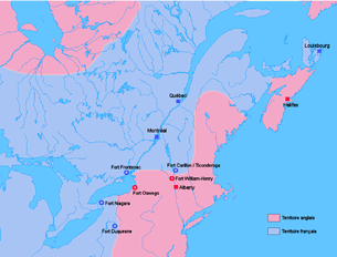
The British formed an aggressive plan of operations for 1755. General Braddock was to lead the expedition to Fort Duquesne.[48] While the Massachusetts provincial governor William Shirley was given the task of fortifying Fort Oswego and attacking Fort Niagara, Sir William Johnson was to capture Fort St. Frédéric (at present-day Crown Point, New York).[49] Lieutenant Colonel Robert Monckton was to capture Fort Beauséjour to the east, on the frontier between Nova Scotia and Acadia.[50]
Braddock (with George Washington as one of his aides) led about 1,500 army troops and provincial militia on an expedition in June 1755 to take Fort Duquesne. The expedition was a disaster. It was attacked by French soldiers and Indian warriors ambushing them from up in trees and behind logs. Braddock called for a retreat. He was killed. Approximately 1,000 British soldiers were killed or injured.[48] The remaining 500 British troops, led by George Washington, retreated to Virginia. Two future opponents in the American Revolutionary War, Washington and Thomas Gage, played key roles in organizing the retreat.
The French acquired a copy of the British war plans, including the activities of Shirley and Johnson. Shirley's efforts to fortify Oswego were bogged down in logistical difficulties, exacerbated by Shirley's inexperience in managing large expeditions. In conjunction, Shirley was made aware that the French were massing for an attack on Fort Oswego in his absence when he planned to attack Fort Niagara. As a response, Shirley left garrisons at Oswego, Fort Bull, and Fort Williams (the latter two located on the Oneida Carry between the Mohawk River and Wood Creek at present-day Rome, New York). Supplies for use in the projected attack on Niagara were cached at Fort Bull.

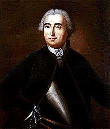
Johnson's expedition was better organized than Shirley's, which was noticed by New France's governor, the Marquis de Vaudreuil. He had primarily been concerned about the extended supply line to the forts on the Ohio, and had sent Baron Dieskau to lead the defenses at Frontenac against Shirley's expected attack. When Johnson was seen as the larger threat, Vaudreuil sent Dieskau to Fort St. Frédéric to meet that threat. Dieskau planned to attack the British encampment at Fort Edward at the upper end of navigation on the Hudson River, but Johnson had strongly fortified it, and Dieskau's Indian support was reluctant to attack. The two forces finally met in the bloody Battle of Lake George between Fort Edward and Fort William Henry. The battle ended inconclusively, with both sides withdrawing from the field. Johnson's advance stopped at Fort William Henry, and the French withdrew to Ticonderoga Point, where they began the construction of Fort Carillon (later renamed Fort Ticonderoga after British capture in 1759).
Colonel Monckton, in the sole British success that year, captured Fort Beauséjour in June 1755, cutting the French fortress at Louisbourg off from land-based reinforcements. To cut vital supplies to Louisbourg, Nova Scotia's Governor Charles Lawrence ordered the deportation of the French-speaking Acadian population from the area. Monckton's forces, including companies of Rogers' Rangers, forcibly removed thousands of Acadians, chasing down many who resisted, and sometimes committing atrocities. More than any other factor, the cutting off of supplies to Louisbourg led to its demise.[51] The Acadian resistance, in concert with native allies, including the Mi'kmaq, was sometimes quite stiff, with ongoing frontier raids (against Dartmouth and Lunenburg among others). Other than the campaigns to expel the Acadians (ranging around the Bay of Fundy, on the Petitcodiac and St. John rivers, and Île Saint-Jean), the only clashes of any size were at Petitcodiac in 1755 and at Bloody Creek near Annapolis Royal in 1757.
French victories, 1756–1757

Following the death of Braddock, William Shirley assumed command of British forces in North America. At a meeting in Albany in December 1755, he laid out his plans for 1756. In addition to renewing the efforts to capture Niagara, Crown Point and Duquesne, he proposed attacks on Fort Frontenac on the north shore of Lake Ontario and an expedition through the wilderness of the Maine district and down the Chaudière River to attack the city of Quebec. Bogged down by disagreements and disputes with others, including William Johnson and New York's Governor Sir Charles Hardy, Shirley's plan had little support.
Newcastle replaced him in January 1756 with Lord Loudoun, with Major General James Abercrombie as his second in command. Neither of these men had as much campaign experience as the trio of officers France sent to North America.[47] French regular army reinforcements arrived in New France in May 1756, led by Major General Louis-Joseph de Montcalm and seconded by the Chevalier de Lévis and Colonel François-Charles de Bourlamaque, all experienced veterans from the War of the Austrian Succession. During that time in Europe, on May 18, 1756, England formally declared war on France, which expanded the war into Europe, which was later to be known as the Seven Years' War.
Governor Vaudreuil, who harboured ambitions to become the French commander in chief (in addition to his role as governor), acted during the winter of 1756 before those reinforcements arrived. Scouts had reported the weakness of the British supply chain, so he ordered an attack against the forts Shirley had erected at the Oneida Carry. In the March Battle of Fort Bull, French forces destroyed the fort and large quantities of supplies, including 45,000 pounds of gunpowder. They set back any British hopes for campaigns on Lake Ontario, and endangered the Oswego garrison, already short on supplies. French forces in the Ohio valley also continued to intrigue with Indians throughout the area, encouraging them to raid frontier settlements. This led to ongoing alarms along the western frontiers, with streams of refugees returning east to get away from the action.
The new British command was not in place until July. When he arrived in Albany, Abercrombie refused to take any significant actions until Loudoun approved them. Montcalm took bold action against his inertia. Building on Vaudreuil's work harassing the Oswego garrison, Montcalm executed a strategic feint by moving his headquarters to Ticonderoga, as if to presage another attack along Lake George. With Abercrombie pinned down at Albany, Montcalm slipped away and led the successful attack on Oswego in August. In the aftermath, Montcalm and the Indians under his command disagreed about the disposition of prisoners' personal effects. The Europeans did not consider them prizes and prevented the Indians from stripping the prisoners of their valuables, which angered the Indians.
Loudoun, a capable administrator but a cautious field commander, planned one major operation for 1757: an attack on New France's capital, Quebec. Leaving a sizable force at Fort William Henry to distract Montcalm, he began organizing for the expedition to Quebec. He was then ordered by William Pitt, the Secretary of State responsible for the colonies, to attack Louisbourg first. Beset by delays of all kinds, the expedition was finally ready to sail from Halifax, Nova Scotia in early August. In the meantime French ships had escaped the British blockade of the French coast, and a fleet outnumbering the British one awaited Loudoun at Louisbourg. Faced with this strength, Loudoun returned to New York amid news that a massacre had occurred at Fort William Henry.
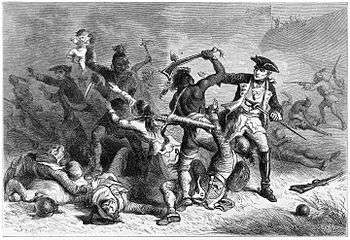
French irregular forces (Canadian scouts and Indians) harassed Fort William Henry throughout the first half of 1757. In January they ambushed British rangers near Ticonderoga. In February they launched a daring raid against the position across the frozen Lake George, destroying storehouses and buildings outside the main fortification. In early August, Montcalm and 7,000 troops besieged the fort, which capitulated with an agreement to withdraw under parole. When the withdrawal began, some of Montcalm's Indian allies, angered at the lost opportunity for loot, attacked the British column, killing and capturing several hundred men, women, children, and slaves. The aftermath of the siege may have contributed to the transmission of smallpox into remote Indian populations; as some Indians were reported to have traveled from beyond the Mississippi to participate in the campaign and returned afterward having been exposed to European carriers.[52]
British conquest, 1758–1760
Vaudreuil and Montcalm were minimally resupplied in 1758, as the British blockade of the French coastline limited French shipping. The situation in New France was further exacerbated by a poor harvest in 1757, a difficult winter, and the allegedly corrupt machinations of François Bigot, the intendant of the territory. His schemes to supply the colony inflated prices and were believed by Montcalm to line his pockets and those of his associates. A massive outbreak of smallpox among western tribes led many of them to stay away from trading in 1758. While many parties to the conflict blamed others (the Indians blamed the French for bringing "bad medicine" as well as denying them prizes at Fort William Henry), the disease was probably spread through the crowded conditions at William Henry after the battle.[53] Montcalm focused his meager resources on the defense of the St. Lawrence, with primary defenses at Carillon, Quebec, and Louisbourg, while Vaudreuil argued unsuccessfully for a continuation of the raiding tactics that had worked quite effectively in previous years.[54]
The British failures in North America, combined with other failures in the European theater, led to the fall from power of Newcastle and his principal military advisor, the Duke of Cumberland. Newcastle and Pitt joined in an uneasy coalition in which Pitt dominated the military planning. He embarked on a plan for the 1758 campaign that was largely developed by Loudoun. He had been replaced by Abercrombie as commander in chief after the failures of 1757. Pitt's plan called for three major offensive actions involving large numbers of regular troops, supported by the provincial militias, aimed at capturing the heartlands of New France. Two of the expeditions were successful, with Fort Duquesne and Louisbourg falling to sizable British forces.
1758
The Forbes Expedition was a British campaign in September–October 1758, with 6,000 troops led by General John Forbes to drive the French out of the contested Ohio Country. After a British advance party on Fort Duquesne was repulsed on September 14, the French withdrew from Fort Duquesne, leaving the British in control of the Ohio River Valley.[55] The great French fortress at Louisbourg in Nova Scotia was captured after a siege.[56]
The third invasion was stopped with the improbable French victory in the Battle of Carillon, in which 3,600 Frenchmen famously and decisively defeated Abercrombie's force of 18,000 regulars, militia and Native American allies outside the fort the French called Carillon and the British called Ticonderoga. Abercrombie saved something from the disaster when he sent John Bradstreet on an expedition that successfully destroyed Fort Frontenac, including caches of supplies destined for New France's western forts and furs destined for Europe. Abercrombie was recalled and replaced by Jeffery Amherst, victor at Louisbourg.

In the aftermath of generally poor French results in most theaters of the Seven Years' War in 1758, France's new foreign minister, the duc de Choiseul, decided to focus on an invasion of Britain, to draw British resources away from North America and the European mainland. The invasion failed both militarily and politically, as Pitt again planned significant campaigns against New France, and sent funds to Britain's ally on the mainland, Prussia, and the French Navy failed in the 1759 naval battles at Lagos and Quiberon Bay. In one piece of good fortune, some French supply ships managed to depart France, eluding the British blockade of the French coast.
1759–1760

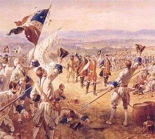
British victories continued in all theaters in the Annus Mirabilis of 1759, when they finally captured Ticonderoga, James Wolfe defeated Montcalm at Quebec (in a battle that claimed the lives of both commanders), and victory at Fort Niagara successfully cut off the French frontier forts further to the west and south. The victory was made complete in 1760 when, despite losing outside Quebec City in the Battle of Sainte-Foy, the British were able to prevent the arrival of French relief ships in the naval Battle of the Restigouche while armies marched on Montreal from three sides.
In September 1760, and before any hostilities erupted, Governor Vaudreuil negotiated from Montreal a capitulation with General Amherst. Amherst granted Vaudreuil's request that any French residents who chose to remain in the colony would be given freedom to continue worshiping in their Roman Catholic tradition, continued ownership of their property, and the right to remain undisturbed in their homes. The British provided medical treatment for the sick and wounded French soldiers and French regular troops were returned to France aboard British ships with an agreement that they were not to serve again in the present war.[57]
End of the war

Most of the fighting between France and Britain in continental North America ended in 1760, while the fighting in Europe continued. The notable exception was the French seizure of St. John's, Newfoundland. When General Amherst heard of this surprise action, he immediately dispatched troops under his nephew William Amherst, who regained control of Newfoundland after the Battle of Signal Hill in September 1762.[58]
Many troops from North America were reassigned to participate in further British actions in the West Indies, including the capture of Spanish Havana when Spain belatedly entered the conflict on the side of France, and a British expedition against French Martinique in 1762, led by (the now) Major General Robert Monckton.[59]
General Amherst also oversaw the transition of French forts in the western lands to British control. The policies he introduced in those lands disturbed large numbers of Indians, and contributed to the outbreak in 1763 of the conflict known as Pontiac's Rebellion.[60] This series of attacks on frontier forts and settlements required the continued deployment of British troops, and was not resolved until 1766.[61]

The war in North America officially ended with the signing of the Treaty of Paris on 10 February 1763, and war in the European theatre of the Seven Years' War was settled by the Treaty of Hubertusburg on 15 February 1763. The British offered France the choice of surrendering either its continental North American possessions east of the Mississippi or the Caribbean islands of Guadeloupe and Martinique, which had been occupied by the British. France chose to cede the former, but was able to negotiate the retention of Saint Pierre and Miquelon, two small islands in the Gulf of St. Lawrence, along with fishing rights in the area. They viewed the economic value of the Caribbean islands' sugar cane to be greater and easier to defend than the furs from the continent. The contemporaneous French philosopher Voltaire referred to Canada disparagingly as nothing more than a few acres of snow. The British, for their part, were happy to take New France, as defence of their North American colonies would no longer be an issue and also because they already had ample places from which to obtain sugar. Spain, which traded Florida to Britain to regain Cuba, also gained Louisiana, including New Orleans, from France in compensation for its losses. Great Britain and Spain also agreed that navigation on the Mississippi River was to be open to vessels of all nations.[62]
Consequences
The war changed economic, political, governmental and social relations between three European powers (Britain, France, and Spain), their colonies and colonists, and the natives that inhabited the territories they claimed. France and Britain both suffered financially because of the war, with significant long-term consequences.

Britain gained control of French Canada and Acadia, colonies containing approximately 80,000 primarily French-speaking Roman Catholic residents. The deportation of Acadians beginning in 1755 resulted in land made available to migrants from Europe and the colonies further south. The British resettled many Acadians throughout its North American provinces, but many went to France, and some went to New Orleans, which they had expected to remain French. Some were sent to colonize places as diverse as French Guiana and the Falkland Islands; these latter efforts were unsuccessful. Others migrated to places like Saint-Domingue, and fled to New Orleans after the Haitian Revolution. The Louisiana population contributed to the founding of the modern Cajun population. (The French word "Acadien" evolved to "Cadien", then to "Cajun".)[63]
Following the treaty, King George III issued the Royal Proclamation of 1763 on October 7, 1763, which outlined the division and administration of the newly conquered territory, and to some extent continues to govern relations between the government of modern Canada and the First Nations. Included in its provisions was the reservation of lands west of the Appalachian Mountains to its Indian population,[64] a demarcation that was at best a temporary impediment to a rising tide of westward-bound settlers.[65] The proclamation also contained provisions that prevented civic participation by the Roman Catholic Canadians.[66] When accommodations were made in the Quebec Act in 1774 to address this and other issues, religious concerns were raised in the largely Protestant Thirteen Colonies over the advance of "popery"; the Act maintained French Civil law, including the seigneurial system, a medieval code soon to be removed from France within a generation by the French Revolution.
The Seven Years' War nearly doubled Great Britain's national debt. The Crown, seeking sources of revenue to pay off the debt, attempted to impose new taxes on its colonies. These attempts were met with increasingly stiff resistance, until troops were called in so that representatives of the Crown could safely perform their duties. These acts ultimately led to the start of the American Revolutionary War.[67]
France attached comparatively little value to its North American possessions, apart from the highly profitable sugar-producing Antilles islands, which it managed to retain. Minister Choiseul considered he had made a good deal at the Treaty of Paris, and philosopher Voltaire wrote that Louis XV had lost "a few acres of snow".[68] For France however, the military defeat and the financial burden of the war weakened the monarchy and contributed to the advent of the French Revolution in 1789.[69]
For many native populations, the elimination of French power in North America meant the disappearance of a strong ally and counterweight to British expansion, leading to their ultimate dispossession.[69] The Ohio Country was particularly vulnerable to legal and illegal settlement due to the construction of military roads to the area by Braddock and Forbes.[70] Although the Spanish takeover of the Louisiana territory (which was not completed until 1769) had modest repercussions, the British takeover of Spanish Florida resulted in the westward migration of tribes that did not want to do business with the British, and a rise in tensions between the Choctaw and the Creek, historic enemies whose divisions the British at times exploited.[71] The change of control in Florida also prompted most of its Spanish Catholic population to leave. Most went to Cuba, including the entire governmental records from St. Augustine, although some Christianized Yamasee were resettled to the coast of Mexico.[72]
France returned to North America in 1778 with the establishment of a Franco-American alliance against Great Britain in the American War of Independence. This time France succeeded in prevailing over Great Britain, in what historian Alfred A. Cave describes as "French [...] revenge for Montcalm's death".[73]
See also
- French and Indian Wars (article includes King William's War, Queen Anne's War, King George's War, and this war.)
- Military history of Nova Scotia
- Northwest Indian War
- Franco-Indian alliance
- Great Britain in the Seven Years' War
- New Hampshire Provincial Regiment
- American Indian Wars
Footnotes
- ↑ Brumwell, pp. 26–31, documents the starting sizes of the expeditions against Louisbourg, Carillon, Duquesne, and West Indies.
- ↑ Brumwell, pp. 24–25.
- ↑ Gary Walton; History of the American Economy; page 27
- ↑ M. Brook Taylor, Canadian History: a Reader's Guide: Volume 1: Beginnings to Confederation (1994) pp 39-48, 72-74
- ↑ The Canadian Encyclopedia
- ↑ "The Siege of Quebec: An episode of the Seven Years' War", Canadian National Battlefields Commission, Plains of Abraham website
- ↑ Lacoursière, Jacques; Provencher, Jean; Vaugeois, Denis (2001). Canada-Québec 1534-2000 (reprint ed.). Les éditions du Septentrion. p. 92. ISBN 9782894481868. Retrieved 2016-06-09.
- ↑ Eccles, France in America, p. 185
- 1 2 3 Anderson (2000), p. 747.
- ↑ Jennings, p. xv.
- ↑ The Canadian Encyclopedia: Seven Years' War.
- ↑ (French) L'Encyclopédie canadienne: Guerre de Sept Ans.
- ↑ Powell, John (2005). Encyclopedia of North American immigration. New York: Facts on File. p. 204. ISBN 0816046581.
- ↑ John Wade, "British History Chronologically Arranged, 2: Comprehending a Chamfied Analysis of Events and Occurencis in Church and State ... from the First Invasions by the Romans to A.d. 1847", p.46
- ↑ Cogliano, Francis D. (2008). Revolutionary America, 1763–1815: A Political History. London: Routledge. p. 32. ISBN 9780415964869.
- ↑ Jennings, pp. 9, 176
- ↑ Anderson (2000), p. 23
- ↑ Jennings, p. 8
- 1 2 3 Anderson (2000), p. 26.
- 1 2 Fowler, p. 14.
- 1 2 "Park Spotlight: Lake Loramie", Ohio State Parks Magazine, Spring 2006
- ↑ Fowler, p. 15.
- ↑ Alfred P. James, The Ohio Company: Its Inner History (1959) pp. 26–40
- ↑ Jennings, p. 15
- ↑ Jennings, p. 18
- ↑ Anderson (2000), p. 28
- ↑ Anderson (2000), p. 27
- ↑ Fowler, p. 31.
- ↑ O'Meara, p. 48
- ↑ Anderson (2000), pp. 42–43
- ↑ Anderson (2000), p. 43
- ↑ Jennings, p. 63
- ↑ Fowler, p. 35.
- ↑ Ellis, His Excellency George Washington, p. 5.
- ↑ Fowler, p. 36.
- ↑ O'Meara, pp. 37–38.
- ↑ O'Meara, p. 41
- ↑ O'Meara, pp. 43–45
- ↑ Jennings, p. 65
- ↑ Anderson (2000), p. 50
- ↑ Anderson (2000), pp. 51–59.
- ↑ Anderson (2000), pp. 59–65.
- ↑ Fowler, p. 52.
- ↑ Lengel p. 52.
- ↑ O'Meara, p. 113.
- ↑ Fowler, pp. 74–75.
- 1 2 Fowler, p. 98.
- 1 2 "The Battle of the Monongahela". World Digital Library. 1755. Retrieved 2013-08-03.
- ↑ O'Meara, pp. 110–111.
- ↑ O'Meara, p. 163.
- ↑ Patterson, Stephen E. (1994). "1744-1763: Colonial Wars and Aboriginal Peoples". In Buckner, Phillip; Reid, John. The Atlantic Region to Confederation: A History. Toronto: University of Toronto Press. p. 152. ISBN 0802005535.
- ↑ Nester, pp. 53–61
- ↑ Fowler, p. 138.
- ↑ Fowler, p. 139.
- ↑ Anderson, Fred (2000). Crucible of War: The Seven Years' War and the Fate of Empire in British North America, 1754–1766. New York: Alfred A. Knopf. pp. 267–285. ISBN 0375406425.
- ↑ William, Wood, The Great Fortress: A Chronicle of Louisbourg 1720–1760 (online from Project Gutenberg)
- ↑ "Treaty of Paris February 10, 1763". FrenchandIndianWar.info. Retrieved January 21, 2015.
- ↑ Anderson (2000), p. 498
- ↑ Cave, p. 21
- ↑ Jennings, p. 439
- ↑ Anderson (2000), pp. 617–632
- ↑ Anderson (2000), pp. 505–506
- ↑ Calloway, pp. 161–164
- ↑ Anderson (2000), pp. 565–566
- ↑ Anderson (2000), pp. 636–637
- ↑ Anderson (2000), p. 568
- ↑ Anderson, Fred. "The Real First World War and the Making of America" American Heritage, November/December 2005.
- ↑ Cave, p. 52
- 1 2 Cave, p. xii
- ↑ Anderson (2000), p. 525
- ↑ Calloway, pp. 133–138
- ↑ Calloway, pp. 152–156
- ↑ Cave, p. 82
Further reading
- Anderson, Fred (2000). Crucible of War: The Seven Years' War and the Fate of Empire in British North America, 1754-1766. New York: Knopf. ISBN 0-375-40642-5.
- Anderson, Fred (2005). The War that Made America: A Short History of the French and Indian War. New York: Viking. ISBN 0-670-03454-1. - Released in conjunction with the 2006 PBS miniseries The War that Made America.
- Brumwell, Stephen (2006). Redcoats: The British Soldier and War in the Americas, 1755-1763. Cambridge University Press. ISBN 978-0-521-67538-3.
- Calloway, Colin G (2006). The Scratch of a Pen: 1763 and the Transformation of North America. Oxford University Press. ISBN 978-0-19-530071-0.
- Cave, Alfred A. (2004). The French and Indian War. Westport, Connecticut - London: Greenwood Press. ISBN 0-313-32168-X.
- Ellis, Joseph J. (2004). His Excellency George Washington. New York: Vintage Books. ISBN 1-4000-3253-9.
- Fowler, William M. (2005). Empires at War: The French and Indian War and the Struggle for North America, 1754-1763. New York: Walker. ISBN 0-8027-1411-0.
- Gipson, Lawrence H. The Great War for the Empire: The Years of Defeat, 1754-1757 (1948); The Great War for the Empire: The Victorious Years, 1758-1760 (1950) highly detailed narrative of the British war in North America and Europe.
- Jennings, Francis (1988). Empire of Fortune: Crowns, Colonies, and Tribes in the Seven Years' War in America. New York: Norton. ISBN 0-393-30640-2.
- Murrin, John M. "The French and Indian War, the American Revolution, and the Counterfactual Hypothesis: Reflections on Lawrence Henry Gipson and John Shy." Reviews in American History 1#3 (1973): 307-318. in JSTOR
- Nester, William R (2000). The first global war: Britain, France, and the fate of North America, 1756–1775. Westport, CT: Praeger. ISBN 978-0-275-96771-0. OCLC 41468552.
- Nester, William R. The French and Indian War and the Conquest of New France (2015). excerpt
- O'Meara, Walter (1965). Guns at the Forks. Englewood Cliffs, NJ: Prentice Hall. ISBN 978-0-8229-5309-8.
- West, Doug (2016) French and Indian War - A Short History 30 Minute Book Series
- "Virtual Vault". Library and Archives Canada.
Further reading
| Library resources about French and Indian War |
- Eckert, Allan W. Wilderness Empire. Bantam Books, 1994, originally published 1969. ISBN 0-553-26488-5. Second volume in a series of historical narratives, with emphasis on Sir William Johnson. Academic historians often regard Eckert's books, which are written in the style of novels, to be unreliable, as they contain things like dialogue that is clearly fictional.
- Parkman, Francis. Montcalm and Wolfe: The French and Indian War. Originally published 1884. New York: Da Capo, 1984. ISBN 0-306-81077-8.
External links
| Wikimedia Commons has media related to French and Indian War. |
- The French and Indian War Website
- Map of French and Indian War. French and British forts and settlements, Indian tribes.
- French and Indian War Profile and Videos - Chickasaw.TV
- The War That Made America from PBS
- FORGOTTEN WAR: Struggle for North America from PBS
- Seven Years' War timeline
- Montcalm and Wolfe, by Francis Parkman online ebook
- Animated Map of the French and Indian War developed by HistoryAnimated.com
| |||||||||||||||||||||||
.svg.png)