Fairlee, Vermont
| Fairlee, Vermont | |
|---|---|
| Town | |
|
Fairlee from Morey Mountain c. 1907 | |
 Located in Orange County, Vermont | |
 Location of Vermont with the U.S.A. | |
| Coordinates: 43°55′N 72°10′W / 43.917°N 72.167°W | |
| Country | United States |
| State | Vermont |
| County | Orange |
| Chartered | 1761[1] |
| Area | |
| • Total | 21.2 sq mi (55.0 km2) |
| • Land | 20.2 sq mi (52.3 km2) |
| • Water | 1.0 sq mi (2.7 km2) |
| Elevation | 430 ft (421 m) |
| Population (2000) | |
| • Total | 967 |
| • Density | 47.9/sq mi (18.5/km2) |
| • Households | 395 |
| • Families | 265 |
| Time zone | EST (UTC-5) |
| • Summer (DST) | EDT (UTC-4) |
| ZIP code | 05045 |
| Area code(s) | 802 |
| FIPS code | 50-25675[2] |
| GNIS feature ID | 1462095[3] |
| Website | http://www.fairleevt.org/ |

Fairlee is a town in Orange County, Vermont, United States. The population was 977 at the 2010 census. It includes the village of Ely. Fairlee is home to Lake Morey, which claims to have the longest ice skating trail in the United States.[4]
History
One of the New Hampshire grants, Fairlee was chartered by Governor Benning Wentworth on September 9, 1761 and awarded to Josiah Channey, Joseph Hubbard and 62 others.[5] It was first settled in 1766. On February 25, 1797, the western half was set off as West Fairlee. The population was 575 by 1859, when it had several sawmills, a gristmill, and an establishment for lead pipe and pumps.[6] The Fairlee Railroad Depot was built in 1848 by the Connecticut & Passumpsic Rivers Railroad. Listed on the National Register of Historic Places in 1998, it is the oldest surviving railroad structure along the Connecticut River.[7]
Geography
According to the United States Census Bureau, the town has a total area of 21.2 square miles (55.0 km2), of which, 20.2 square miles (52.3 km2) of it is land and 1.0 square miles (2.7 km2) of it (4.90%) is water. Bounded by the Connecticut River, Fairlee is drained by Glen Falls Brook, Big Brook and the outlet of Lake Morey.
Demographics
| Historical population | |||
|---|---|---|---|
| Census | Pop. | %± | |
| 1790 | 463 | — | |
| 1800 | 386 | −16.6% | |
| 1810 | 983 | 154.7% | |
| 1820 | 1,143 | 16.3% | |
| 1830 | 656 | −42.6% | |
| 1840 | 644 | −1.8% | |
| 1850 | 575 | −10.7% | |
| 1860 | 549 | −4.5% | |
| 1870 | 416 | −24.2% | |
| 1880 | 469 | 12.7% | |
| 1890 | 398 | −15.1% | |
| 1900 | 438 | 10.1% | |
| 1910 | 438 | 0.0% | |
| 1920 | 459 | 4.8% | |
| 1930 | 456 | −0.7% | |
| 1940 | 535 | 17.3% | |
| 1950 | 571 | 6.7% | |
| 1960 | 569 | −0.4% | |
| 1970 | 604 | 6.2% | |
| 1980 | 770 | 27.5% | |
| 1990 | 883 | 14.7% | |
| 2000 | 967 | 9.5% | |
| 2010 | 977 | 1.0% | |
| Est. 2014 | 987 | [8] | 1.0% |
| U.S. Decennial Census[9] | |||
As of the census[2] of 2000, there were 967 people, 395 households, and 265 families residing in the town. The population density was 47.9 people per square mile (18.5/km2). There were 575 housing units at an average density of 28.5 per square mile (11.0/km2). The racial makeup of the town was 97.52% White, 0.21% African American, 0.10% Native American, 0.52% Asian, 0.21% from other races, and 1.45% from two or more races. Hispanic or Latino of any race were 0.83% of the population.
There were 395 households out of which 31.4% had children under the age of 18 living with them, 54.2% were married couples living together, 7.8% had a female householder with no husband present, and 32.7% were non-families. 25.1% of all households were made up of individuals and 10.1% had someone living alone who was 65 years of age or older. The average household size was 2.42 and the average family size was 2.88.
In the town, the population was spread out with 23.6% under the age of 18, 7.2% from 18 to 24, 28.3% from 25 to 44, 25.4% from 45 to 64, and 15.4% who were 65 years of age or older. The median age was 41 years. For every 100 females there were 96.9 males. For every 100 females age 18 and over, there were 96.5 males.
The median income for a household in the town was $44,018, and the median income for a family was $48,250. Males had a median income of $31,736 versus $25,217 for females. The per capita income for the town was $18,454. About 2.6% of families and 5.6% of the population were below the poverty line, including 4.7% of those under age 18 and 13.4% of those age 65 or over.
Sites of interest
- Fairlee Railroad Depot
- Lake Morey
- Camp Billings
- Aloha Foundation
Infrastructure
Transportation
The town is crossed by ![]() Interstate 91,
Interstate 91, ![]() U.S. Route 5, and
U.S. Route 5, and ![]() Vermont Route 244.
Vermont Route 244.
Notable people
- Helen Gahagan Douglas, actress and US congresswoman[10][11]
- Milton Friedman, economist, former resident of Ely[12]
- William H. Gilmore, Adjutant General of the Vermont National Guard[13]
- Richard W. Mallary, US congressman[14]
- Samuel Morey, inventor[15]
- George W. Morrison, US congressman[16]
- Nathaniel Niles, politician[17]
- Stephen Thomas, politician and brigadier general[18]
References
- ↑ "Town of Fairlee Vermont". Town of Fairlee Vermont. Retrieved October 22, 2012.
- 1 2 "American FactFinder". United States Census Bureau. Retrieved 2008-01-31.
- ↑ "US Board on Geographic Names". United States Geological Survey. 2007-10-25. Retrieved 2008-01-31.
- ↑ Lake Morey Ice Skating Trail
- ↑ A. J. Coolidge & J. B. Mansfield, A History and Description of New England; Boston, Massachusetts 1859
- ↑ A. J. Coolidge & J. B. Mansfield, A History and Description of New England; Boston, Massachusetts 1859
- ↑ National Register of Historic Places -- Fairlee Railroad Depot
- ↑ "Annual Estimates of the Resident Population for Incorporated Places: April 1, 2010 to July 1, 2014". Retrieved June 4, 2015.
- ↑ "U.S. Decennial Census". United States Census Bureau. Retrieved May 16, 2015.
- ↑ Sally Denton, The Pink Lady: The Many Lives of Helen Gahagan Douglas, 2009, page 12
- ↑ Edward T. James, Janet Wilson James, Paul S. Boyer, Notable American Women: A Biographical Dictionary, Volume 5, 2004, page 178
- ↑ Smith, Win (16 June 2010). "Myt Turn:Taxes put sustainability at risk". Burlington, Vermont: Burlington Free Press. pp. 6A.
- ↑ Vermont Historical Society, Proceedings of the Vermont Historical Society, 1915, page 203
- ↑ "MALLARY, Richard Walker, (1929 - 2011)". Biographical Directory of the United States Congress. Retrieved October 22, 2012.
- ↑ "Samuel Morey". Find A Grave. Retrieved October 22, 2012.
- ↑ "MORRISON, George Washington, (1809 - 1888)". Biographical Directory of the United States Congress. Retrieved October 22, 2012.
- ↑ "Niles, Nathaniel (1741-1828)". The Political Graveyard. Retrieved October 22, 2012.
- ↑ "Stephen Thomas". Vermont in the Civil War. Retrieved October 22, 2012.
External links
| Wikivoyage has a travel guide for Fairlee (Vermont). |
| Wikimedia Commons has media related to Fairlee, Vermont. |
- Town of Fairlee
- Fairlee Public Library
- Fairlee Historical Society
- City-Data.com
- ePodunk: Profile for Fairlee, Vermont
 |
Bradford | Piermont, NH | | |
| West Fairlee | |
Orford, NH | ||
| ||||
| | ||||
| Thetford | Lyme, NH |
Coordinates: 43°56′13″N 72°10′05″W / 43.937°N 72.168°W
Municipalities and communities of Orange County, Vermont, United States | ||
|---|---|---|
| Towns | 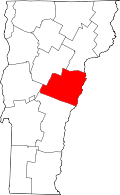 | |
| Villages | ||
| CDPs | ||
| Other communities | ||