West River (Vermont)
The West River is a tributary of the Connecticut River, about 53.8 miles (86.6 km) long,[1] in southern Vermont in the United States.[2] According to the Geographic Names Information System, it has also been known historically as "Wantastiquet" and as "Waters of the Lonely Way".[3] Its watershed covers 423 square miles; land use is about 90% forested and 3% agricultural, and the upper river supports wild native brook and wild brown trout, while Atlantic salmon occur in most of the river.[4]
The West River rises in the Green Mountains[2] in the town of Mount Holly in southeastern Rutland County and flows southwardly through southwestern Windsor County into Windham County, where it turns southeastwardly. Along its course it flows through or along the boundaries of the towns of Weston, Londonderry, Jamaica, Townshend, Brookline, Newfane (where it collects the Rock River), and Dummerston to Brattleboro, where it flows into the Connecticut River.[5]
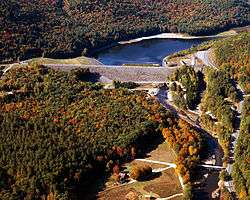
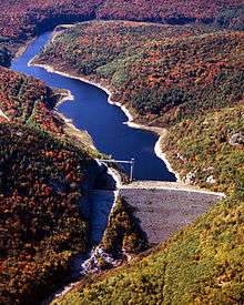
U.S. Army Corps of Engineers dams on the West cause the river to form Ball Mountain Lake and Townshend Lake, both of which were built for the purpose of flood control in 1961.[6][7] The river between Ball Mountain Lake and Townshend Lake is used for white water boating during releases from the Ball Mountain Dam (usually occurring during one weekend in April and one weekend in September).[8][9]
See also
References
- ↑ U.S. Geological Survey. National Hydrography Dataset high-resolution flowline data. The National Map, accessed April 1, 2011
- 1 2 Columbia Gazetteer of North America entry
- ↑ U.S. Geological Survey Geographic Names Information System: West River
- ↑ West River basin summary http://www.vermontconservation.org/Basin-11/West-River-Summary.html
- ↑ DeLorme (1996). Vermont Atlas & Gazetteer. Yarmouth, Maine: DeLorme. ISBN 0-89933-016-9
- ↑ Ball Mountain Lake website
- ↑ Townshend Lake website
- ↑ Zoar Outdoor West River info
- ↑ Rafting America West River info
External links
- Friends of the West River Organization working to restore traditional whitewater releases to the West River, VT.
Coordinates: 43°20′00″N 72°47′17″W / 43.3332185°N 72.7881521°W