California Historical Landmarks in Yuba County, California
This list includes properties and districts listed on the California Historical Landmark listing in Yuba County, California. Click the "Map of all coordinates" link to the right to view a Google map of all properties and districts with latitude and longitude coordinates in the table below.
| Image | [1] | Landmark name | Location | City or town | Summary |
|---|---|---|---|---|---|
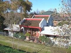 |
889 | Bok Kai Temple | First and D Sts. 39°08′06″N 121°35′13″W / 39.134994°N 121.586953°W |
Marysville | Also on the NHRP list as NPS-75000498 |
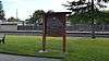 |
493 | Johnson's Ranch | Tomita Park 39°00′37″N 121°25′23″W / 39.0103°N 121.422917°W |
Wheatland | |
 |
934 | Marysville Assembly Center | Aarboga Community |
Marysville | |
 |
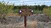
799-3 | Overland Emigrant Trail | Spenceville Rd. 39°02′23″N 121°23′06″W / 39.039633°N 121.385033°W |
Wheatland | |
| 321 | Smartsville | Historic district 39°12′27″N 121°17′55″W / 39.2075°N 121.298611°W |
Smartsville | ||
| 320 | Timbuctoo | Historic district 39°13′01″N 121°19′07″W / 39.216944°N 121.318611°W |
Timbuctoo | ||
 |
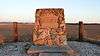
1003 | Wheatland Hop Riot | S. 'A' St. and 6th St. 39°00′46″N 121°25′08″W / 39.012667°N 121.418833°W |
Wheatland |
See also
| Wikimedia Commons has media related to California Historical Landmarks in Yuba County, California. |
- List of California Historical Landmarks
- National Register of Historic Places listings in Yuba County, California
References
This article is issued from Wikipedia - version of the 9/22/2015. The text is available under the Creative Commons Attribution/Share Alike but additional terms may apply for the media files.