Santa Rosa Wilderness
| Santa Rosa Wilderness | |
|---|---|
|
IUCN category Ib (wilderness area) | |
 | |
| Location | Riverside County, California |
| Nearest city | Palm Desert, California |
| Coordinates | 33°30′54″N 116°19′04″W / 33.51500°N 116.31778°WCoordinates: 33°30′54″N 116°19′04″W / 33.51500°N 116.31778°W[1] |
| Area | 72,259 acres (292.42 km2) |
| Established | 1984 (California Wilderness Act) |
| Governing body | U.S. Bureau of Land Management / U.S. Forest Service |
The Santa Rosa Wilderness is a 72,259-acre (292.42 km2) wilderness area in Southern California, in the Santa Rosa Mountains of Riverside and San Diego counties, California. It is in the Colorado Desert section of the Sonoran Desert, above the Coachella Valley and Lower Colorado River Valley regions in a Peninsular Range, between La Quinta to the north and Anza Borrego Desert State Park to the south. The United States Congress established the wilderness in 1984 with the passage of the California Wilderness Act (Public Law 98-425), managed by the both US Forest Service (San Bernardino National Forest, 13,801 acres[2]) and the Bureau of Land Management (58,458 acres [2]). In 2009, the Omnibus Public Land Management Act (P.L. 111-11) was signed into law which added more than 2,000 acres (8.1 km2). Most of the Santa Rosa Wilderness is within the Santa Rosa and San Jacinto Mountains National Monument.
The Santa Rosa Mountains have areas of cultural significance containing primitive trails, roasting pits, milling stations, rock shelters and examples of rock art. Native Americans have identified areas that are currently used for temporary habitation, resource collection and ritual hunting. Remains of historical early settlement and mining include quarry sites, mining prospects and water improvements associated with natural springs.
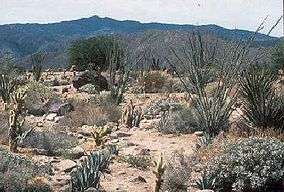
Wildlife, vegetation and topography
The wilderness protects habitat that supports the largest herd of Peninsular bighorn sheep (Ovis canadensis) in the country.[3] The Bighorn Institute, a non-profit research group established in 1982 by several biologists and veterinarians, estimates approximately 60 adult sheep live in the Santa Rosa Mountains,[4] and a total population of 800 sheep in the Peninsular Ranges north of Mexico.
The Peninsular Range bighorn sheep (United States population) is a subspecies that has been protected since 1971 under the California Endangered Species Protection Act and federally protected since 1998 under the Endangered Species Act (ESA).[5] The Peninsular Range bighorn sheep herd utilize the entire range between 1,000 to 4,000 feet (1,200 m) elevation. Bear Creek, Deep Canyon and Martinez Canyon are important as summer concentration areas and provide the rugged escape terrain necessary for lambing. Besides bighorn sheep, there are also mule deer, bobcat and coyote.
Native rare plants in the Santa Rosa Wilderness include shrubs such as Santa Rosa sage (Salvia eremostachya), and Nuttall's scrub oak (Quercus dumosa). Perennial herbs include Santa Rosa Mountains leptosiphon ( Linanthus floribundus ssp. hallii), and triple ribbed milkvetch (Astragalus tricarinatus).
The rugged terrain is formed by uplifted blocks of igneous and metamorphic rocks situated between two major tectonic fault zones, the San Andreas and the San Jacinto. Perennial streams erode the steep-walled canyons and support large fan palm oases. The Santa Rosa Mountain range and the two faults all trend northwest-southeast and are part of the Peninsular Ranges that extend from Southern California to Baja, Mexico.
Recreation
The Santa Rosa Wilderness joins wilderness areas in the San Bernardino National Forest along its western border and the designated California State Wilderness in Anza Borrego Desert State Park to the south.[6][7]
Recreational activities in the Santa Rosa Wilderness include backpacking, horseback riding, day hiking, and nature study/photography.[8]
- The Boo Hoff equestrian trail is one of the few trails in the wilderness that is constructed and maintained by a local equestrian club.
- The Cactus Spring Trail which is an ancient aboriginal pathway, links the Santa Rosa plateau with the desert floor in the Coachella Valley. To the west, this trail connects with designated wilderness areas in the San Bernardino National Forest.
- Oases trails
- Bear Creek Oasis[9]
- Lost Canyon Oasis
- Guadelupe Canyon and Devil Canyon
- Rockhouse Canyon and valley, in the southern wilderness area, has remnants of early Native American and European settlers.
- Rabbit Peak, located near the southeastern boundary, is a notable desert peak for its challenging climb to the 6,623-foot (2,019 m) summit. Local Sierra Club chapters lead organized day and overnight trips to the peak. Universities and local colleges utilize the Santa Rosa Mountains frequently as a living laboratory for scientific and informal studies and outings.
Hunting is restricted to the southem half of the wilderness since the northern portion is located within a State Wildlife Refuge. Deer, quail and dove are hunted in season.
See also
- Category:Fauna of the Colorado Desert
- List of Sonoran Desert wildflowers
- Category:Geography of the Colorado Desert
Notes
- ↑ USGS Feature Detail Report
- 1 2 "Acreage breakdown by agency". Wilderness.net. Retrieved 2009-07-01.
- ↑ "Santa Rosa Additions Wilderness". Department of Interior / Bureau of Land Management. Retrieved 2009-07-01.
- ↑ "Research Projects". Bighorn Institute. Retrieved 2009-07-02.
- ↑ "News Release". US Fish and Wildlife Service. March 13, 1998. Retrieved 2009-07-01.
- ↑ http://www.blm.gov/ca/pa/wilderness/wilderness_pdfs/maps/1page/palmsprings/santa_rosa.pdf . accessed 6/20/2010
- ↑ http://www.parks.ca.gov/?page_id=638 Anza Borrego Desert State Park . accessed 6/20/2010
- ↑ http://www.blm.gov/ca/pa/wilderness/wa/areas/santa_rosa.html . accessed 6/20/2010
- ↑ http://www.hiking-in-ps.com/bearcreek.php
References
External links
- Official Santa Rosa Wilderness website
- BLM Santa Rosa Wilderness Map
- http://www.blm.gov/ca/st/en/prog/wilderness/wa/photos/santarosa.html [Santa Rosa Wilderness photographs]
- University of California: Boyd Deep Canyon Desert Research Center
- Summitpost's webpage on Rabbit Peak.