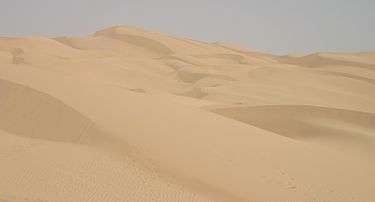
Algodones Dunes
| Algodones Dunes | |
|---|---|
|
The dunes from space | |
| Location | Sonoran Desert, Imperial County, California, United States |
| Coordinates | 32°55′N 115°3′W / 32.917°N 115.050°WCoordinates: 32°55′N 115°3′W / 32.917°N 115.050°W |
| Length | 45 miles (72 km) |
| Width | 6 miles (9.7 km) |
| Geology | Erg |

The Algodones Dunes is a large erg (sand dune field) located in the southeastern portion of the U.S. state of California, near the border with Arizona and the Mexican state of Baja California. The field is approximately 45 miles long by 6 miles wide and extends along a northwest-southeast line that correlates to the prevailing northerly and westerly wind directions. The name "Algodones Dunes" refers to the entire geographic feature, while the administrative designation for that portion managed by the Bureau of Land Management is the Imperial Sand Dunes Recreation Area (sometimes called the Glamis Dunes). The Algodones Dunes are split into many different sections. These sections include Glamis, Gordon's Well, Buttercup, Midway, and Patton's Valley. Although the Spanish word algodones translates to the English word cotton, the name Algodones is a corruption of the Spanish and English names of the Yuman tribe that once dwelt nearby.[1]
Location
The dunes are located west of the Chocolate Mountains in Imperial County, and are crossed by Interstate 8 and State Route 78, which passes through the old train stop of Glamis at the eastern edge of the dune field. The northwestern end is located at 33°8′53″N 115°19′29″W / 33.14806°N 115.32472°W about 11 mi (18 km) east of Calipatria, California, and the southeastern end is located at 32°41′4″N 114°46′7″W / 32.68444°N 114.76861°W near Los Algodones in Mexico, about 6 miles west of Yuma, Arizona. The dunes are also now separated at the southern end by agricultural land from the much more extensive Gran Desierto de Altar, to which they once were linked as an extreme peripheral "finger". The only significant human-made structures in the area are the All-American Canal that cuts across the southern portion from east to west and the Coachella Canal on the western edge.
History
Because the Colorado River flowed through very flat terrain, the course of the river varied over a wide area, being periodically diverted in one direction or another by silt deposits remaining after floods. Sometimes the river flowed into the Gulf of California, as it does today; other times it turned westward toward the Salton Sink. Each time the Salton Sink received the river flow, a large freshwater lake called Lake Cahuilla formed. The last Lake Cahuilla covered much of the Imperial, Coachella and Mexicali Valleys as late as 1450. The most popular theory holds that the Algodones Dunes were formed from windblown beach sands of Lake Cahuilla. The prevailing westerly and northwesterly winds carried the sand eastward from the old lake shore to their present location which continues to migrate southeast by approximately one foot per year.[2]
The dunes have frequently been a barrier to human movement in the area. Foot travelers frequently diverted south into Mexico, and in 1877 the Southern Pacific Railroad was diverted north to avoid the dunes, but in 1915 Colonel Ed Fletcher built a wooden plank road across the dunes to prove that cars could cross the dunes and to connect San Diego with Yuma, Arizona. This trail eventually became part of Interstate 8. During World War II, the U.S. military conducted desert warfare training on the dunes, which were part of the California-Arizona Maneuver Area. People have been driving on the dunes for recreation almost since vehicles first reached the area, which may have been the proving ground for the first dune buggy, a modified Ford Model A. Off-road driving surged following World War II when surplus Jeeps became available to the public.[2]
Current recreational use

Environmental protection groups (notably the Center for Biological Diversity[3]) and off-highway vehicle advocacy groups (notably the American Sand Association[4]) have filed numerous petitions and lawsuits to either restrict or re-open vehicular access to the dunes. Most of the dunes located north of State Route 78 are off-limits to vehicular traffic due to designation as the North Algodones Dunes Wilderness. The federal government protected these 25,818 acres (10,448 ha) in the early 1980s and closed them to vehicles as part of the 1994 California Desert Protection Act (Public Law 103-433). Much of the area south of this road remains open for off-highway vehicle use, though a lawsuit in 2000 closed over 49,000 acres (20,000 ha) to vehicular access, leaving about 40% of the recreation area open to vehicles. It is the largest sand dunes open to off-highway vehicle use in the United States.[5] The site's large sand dunes are a preferred terrain for many off-road vehicle owners. Motorcycles, sandrails, ATVs, and 4-wheel-drive vehicles are commonly driven across the dunes. Open camping is permitted, and on major winter holidays, as many as 150,000 people can visit in a single weekend.[6] These recreationalists bring an economic boom during the cooler months to the nearby towns of Brawley, California, Yuma, Arizona and El Centro, California.
Endemic species

As they are the largest dune ecosystem in the United States, there are many species which are endemic to the Algodones system, so the region overall is biologically unique on a global scale. The Algodones were once part of an even greater dune system that now resides primarily in the Mexican state of Sonora, with a few extensions also in southwestern Arizona, especially in the vicinity of Yuma. Accordingly, it is likely that many of the species presently known only from the Algodones also occur in the Gran Desierto de Altar in Mexico, but this is difficult to ascertain without biological surveys of the latter area.
- The perennial plant Peirson's milkvetch (Astragalus magdalenae var. peirsonii) is found in the Algodones and is listed as a threatened species under the U.S. Endangered Species Act and as an endangered species under the California Endangered Species Act.[7][8] The plant germinates only during years of sufficient rainfall. During one such year, over 71,000 plants were found in the open areas of the dunes, and it is suspected at least that many more in the closed areas.[4]
Among insects, there are dozens of species found only in Algodones or its neighboring areas, including:
- Pseudocotalpa andrewsi — (a scarab beetle)
- Pseudocotalpa sonorica — (a scarab beetle)
- Anomala hardyorum — (a scarab beetle)
- Megasoma sleeperi — (a scarab beetle)
- Trigonoscuta rothi rothi — (a weevil)
- Trigonoscuta rothi algodones — (a weevil)
- Trigonoscuta rothi imperialis — (a weevil)
- Trigonoscuta rothi punctata — (a weevil)
- Lepismadora algodones — the Algodones sand jewel beetle
- Agrilus harenus — (a buprestid beetle)
- Prasinalia imperialis — (a buprestid beetle)
- Microbembex elegans — (a Sand wasp)
- Stictiella villegasi — (a Sand wasp)
- Plenoculus n. sp. — (a crabronid wasp)
- Perdita glamis — (an andrenid bee)
- Perdita algodones — (an andrenid bee)
- Perdita frontalis — (an andrenid bee)
- Euparagia n. sp. — (a vespid wasp)
- Dasymutilla nocturna — (a velvet ant)
- Efferia macroxipha — (a robber fly)
In August 2006, Federal wildlife officials decided not to list these species under the Endangered Species Act, due primarily to insufficient documentation of their distribution and phenology; biological survey work is planned to address this.[9]
Movie setting
The dunes were used to film parts of Road to Morocco, Flight of the Phoenix, Tobruk, Stargate, Resident Evil: Extinction and the Tatooine scenes in Return of the Jedi. John Ford made the 1934 version of The Last Patrol here. They also appear in the opening sequence of the TV series Kung Fu.
View

Gallery
-

Algodones Dunes
-

True-colour satellite image of the Algodones Dunes.
-

Drag Racing Spectators In The San Haze At The Dunes - Presidents Day Weekend.
-

Barrier at the US-Mexico border through the dunes.
References
- ↑ Rare and endangered plans of the Algodones Dunes GlamisOnLine. Retrieved on August 25, 2012.
- 1 2 Where Did the Sand Dunes Come From? Bureau of Land Management. Retrieved on February 18, 2007.
- ↑ Center for Biological Diversity, Algodones Dunes
- 1 2 American Sand Association. Retrieved on February 18, 2007.
- ↑ http://www.duneguide.com/sand_dune_guide_isdra.htm
- ↑ Sandsports at Off-Road.com. Retrieved on February 18, 2007.
- ↑ Bureau of Land Management, El Centro Field Office. Retrieved on February 18, 2007.
- ↑ California Department of Fish and Game. Retrieved February 18, 2007
- ↑ U.S. Fish & Wildlife Service report Retrieved on February 20, 2007
- ↑ Salton Trough July 29, 2013
External links
| Wikimedia Commons has media related to Algodones Dunes. |
- Bureau of Land Management site for the Imperial Sand Dunes
- Bureau of Land Management site for the North Algodones Dunes Wilderness
- Center for Biological Diversity
- North American Atlas 2006, pg. 17
- "Algodones Dunefield, California". NASA Earth Observatory. Retrieved 2006-05-01.
- wilderness.net: North Algodones Dunes Wilderness
- Glamis Picture Gallery
- Glamis Sand Dunes on Dirtopia
- Imperial Sand Dunes on DuneGuide.com
- Glamis Dunes website of information, forums and links
- Glamis Camping Information