Batavia Township, Kane County, Illinois
| Batavia Township | |
|---|---|
| Township | |
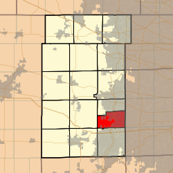 Location in Kane County | |
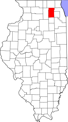 Kane County's location in Illinois | |
| Coordinates: 41°49′59″N 088°18′59″W / 41.83306°N 88.31639°WCoordinates: 41°49′59″N 088°18′59″W / 41.83306°N 88.31639°W | |
| Country | United States |
| State | Illinois |
| County | Kane |
| Established | November 6, 1849 |
| Area | |
| • Total | 18.7 sq mi (48 km2) |
| • Land | 18.31 sq mi (47.4 km2) |
| • Water | 0.39 sq mi (1.0 km2) 2.09% |
| Elevation[1] | 692 ft (211 m) |
| Population (2010) | |
| • Total | 35,221 |
| • Density | 1,923.9/sq mi (742.8/km2) |
| FIPS code | 17-04091[2] |
| GNIS feature ID | 0428640 |
| Website |
www |
Batavia Township is located in Kane County, Illinois. It is divided by the Fox River. As of the 2010 census, its population was 35,221 and it contained 12,892 housing units.[3] The western part of the United States Department of Energy's Fermilab is located at the eastern edge of the township (formerly in the village of Weston), although most of the facility is located in neighboring Winfield Township in DuPage County.
Geography
Unlike the prototypical Midwestern township, which is a six mile by six mile square, Batavia splits such a 6-mile (9.7 km) square with Geneva Township. According to the 2010 census, the township has a total area of 18.7 square miles (48 km2), of which 18.31 square miles (47.4 km2) (or 97.91%) is land and 0.39 square miles (1.0 km2) (or 2.09%) is water.[3]
Cities and towns
- Batavia (vast majority)
- North Aurora (northern half)
- Aurora (small part)
Unincorporated towns
Adjacent townships
- Geneva Township (north)
- Winfield Township (east)
- Blackberry Township (west)
- Aurora Township (south)
- Naperville Township (southeast)
- Sugar Grove Township (southwest)
School districts
- Batavia Public School District 101
- West Aurora Public School District 129
Cemeteries
The township contains Westside, Eastside, and River Hills cemeteries.
Major highways
Notes
- ↑ "US Board on Geographic Names". United States Geological Survey. 2007-10-25. Retrieved 2008-01-31.
- ↑ "American FactFinder". United States Census Bureau. Archived from the original on 2013-09-11. Retrieved 2008-01-31.
- 1 2 "Population, Housing Units, Area, and Density: 2010 - County -- County Subdivision and Place -- 2010 Census Summary File 1". United States Census. Retrieved 2013-05-28.
References
- "Batavia Township, Kane County, Illinois". Geographic Names Information System. United States Geological Survey. Retrieved 2010-01-17.
- Illinois Regional Archives Depository System. "Name Index to Illinois Local Governments". Illinois State Archives. Illinois Secretary of State.
External links
Municipalities and communities of Kane County, Illinois, United States | ||
|---|---|---|
| Cities | ||
| Villages | ||
| Townships |
| |
| CDP | ||
| Other unincorporated communities |
| |
| Footnotes | ‡This populated place also has portions in an adjacent county or counties | |