Huntley, Illinois
| Huntley, Illinois | |
| Village | |
.jpg) Huntley High School, located in the western part of Huntley, serves all high school aged students in Consolidated School District 158 | |
| Name origin: Thomas Stillwell Huntley[1] | |
| Motto: The Friendly Village with Country Charm | |
| Country | United States |
|---|---|
| State | Illinois |
| Counties | McHenry, Kane |
| Townships | Grafton (McHenry), Rutland (Kane) |
| Elevation | 889 ft (271 m) |
| Coordinates | 42°09′42″N 88°26′03″W / 42.16167°N 88.43417°WCoordinates: 42°09′42″N 88°26′03″W / 42.16167°N 88.43417°W |
| Area | 14.10 sq mi (37 km2) |
| - land | 14.07 sq mi (36 km2) |
| - water | 0.03 sq mi (0 km2) |
| Population | 25,603 (2014) |
| Density | 489.1/sq mi (189/km2) |
| Founded | 1851 |
| - Incorporated | 1872 |
| Government | Council–manager |
| Village President | Charles Sass |
| Timezone | CST (UTC-6) |
| - summer (DST) | CDT (UTC-5) |
| Postal code | 60142 |
| Area codes | 847, 224 |
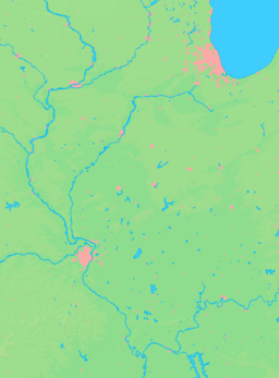  Location of Huntley within Illinois | |
| Wikimedia Commons: Huntley, Illinois | |
| Statistics: [2][3][4] | |
| Website: www.huntley.il.us | |
| [5] | |
Huntley is a village in McHenry and Kane Counties, Illinois. In 2008, the U.S. Census Bureau estimated the village's population to be 22,923.[2] As of the 2000 Census,[3] the village had 5,730 people, meaning the village's population had quadrupled in eight years. At the 2010 census, the village's population was 24,291.[6] Government officials in Huntley, an outer suburb of Chicago, have adopted an aggressive development strategy regarding this population growth.
Huntley is best known for its Premium Outlets mall[7] and Sun City retirement community, the largest in the Midwest. The old part of Huntley is also known for its public square which features a gazebo, as well as a full brick-paved street (Woodstock St.) and 1950s-style diner, The Huntley Dairy Mart. The village's slogan is "The Friendly Village with Country Charm."
History
McHenry County was established in 1837, and in 1838 the first settlers, mostly from New England, came to Grafton Township. One of these families, Prescott and Lucy Geer Whittemore, of Grafton, New Hampshire, settled west of the future town. Thomas Stillwell and Eliza Fox Huntley and children, Charles, Harriet, and William arrived in 1846. The Huntleys acquired land north of the future village and later expanded their holdings to the south.[1]
The Chicago and Galena Railroad constructed a railroad in 1851, which reached as far northwest as Huntley Grove (another town in Illinois was named "Huntley's Grove" around the same time, but the name was changed to DeKalb). The railroad owners hosted an excursion trip on September 5, 1851, which marked the maiden voyage, to Huntley Station, and that was the beginning of Huntley (the “Grove” and “Station” words were later dropped). The Chicago Tribune article that described the 1851 excursion trip stated that there were a few frame houses near the railroad and Mr. Huntley soon built a general store there as well.
Procurement of land was based on government grants. Louise Kreutzer, a Huntley native, tells of land regularly changing hands due to settlers’ inability to make mortgage payments and wealthy landowners being quick to foreclose. Despite early hardships, the village grew slowly and steadily. Stewart Cummings was the first postmaster in 1851 and when the village was incorporated in 1872, John S. Cummings, a Civil War veteran became the first mayor.
The Chicago and Galena Railroad became the Chicago and Northwestern Railroad, and later, Union Pacific Railroad, and served the community for over 150 years, though passenger service was eliminated in about 1950. The railroad was critical to the economic development of Huntley because it provided the means of sending agriculture products to the Chicago market and led to Huntley’s preeminence as a dairy center. In addition to shipping dairy products directly to Chicago, milk producers sold milk to local factories, which processed condensed milk, butter and cheese. There is a strong possibility that passenger train service will be reinstated in the future.
The town center was a thriving locale with a variety of retail and service businesses. In 1906, the Elgin and Belvidere Electric Railroad constructed a system linking the two larger cities with all the communities between and provided hourly passenger service in each direction. When more roads were paved and automobiles became prevalent, the use of the electric railroad diminished, and it closed in 1930.
When Huntley was platted in 1853, land was set aside in the center of town for a town park. Maps as early as 1872 show the area as open space. A wooden pump stood in the center of the park serving as a water supply for both horses and firefighting. With Huntley’s development as a dairy center, horses were tied to the hitching rail surrounding the park every morning while farmers visited stores after delivering their milk cans at the railroad or factory. On milk contract signing days, the four sides of the park were thickly clustered with horses and wagons. The park was and is an object of pride to the residents. A band shell stood near the center of the park where the brass band performed patriotic music before some of the members marched off to the Civil War. After World War I, Andrew Schmitt, a stonemason, was commissioned by the Huntley Women’s Club to set a stone as a memorial for those who served in the war. He also set a small cannon on a rock base as a memorial. A new gazebo replaced the band shell in the 1990s and is surrounded by trees and shrubs and beautiful flowerbeds. A memorial brick sidewalk marking Huntley’s Sesquicentennial surrounds the gazebo, where a time capsule marking the event is buried. The square was named James Dhamer Park in memory of the 14-year mayor after his death in 1999.[1]
Geography
Huntley is located at 42°09′42″N 88°26′03″W / 42.1615479°N 88.4342740°W (42.1615479, -88.4342740).[5]
According to the 2010 census, Huntley has a total area of 14.102 square miles (36.52 km2), of which 14.07 square miles (36.44 km2) (or 99.77%) is land and 0.032 square miles (0.08 km2) (or 0.23%) is water.[8]
Demographics
| Historical population | |||
|---|---|---|---|
| Census | Pop. | %± | |
| 1880 | 505 | — | |
| 1890 | 550 | 8.9% | |
| 1910 | 773 | — | |
| 1920 | 720 | −6.9% | |
| 1930 | 670 | −6.9% | |
| 1940 | 674 | 0.6% | |
| 1950 | 830 | 23.1% | |
| 1960 | 1,143 | 37.7% | |
| 1970 | 1,432 | 25.3% | |
| 1980 | 1,646 | 14.9% | |
| 1990 | 2,453 | 49.0% | |
| 2000 | 5,730 | 133.6% | |
| 2010 | 24,291 | 323.9% | |
| Est. 2015 | 26,005 | [9] | 7.1% |
As of the census[3] of 2000, there were 5,730 people, 2,324 households, and 1,756 families residing in the village. The population density was 489.1 inhabitants per square mile (188.8/km2). There were 2,501 housing units at an average density of 213.5 per square mile (82.4/km2). The racial makeup of the village was 94.94% White, 0.44% African American, 0.17% Native American, 2.13% Asian, 0.00% Pacific Islander, 1.26% from other races, and 1.06% from two or more races. 4.28% of the population were Hispanic or Latino of any race.
There were 2,324 households out of which 31.2% had children under the age of 18 living with them, 67.3% were married couples living together, 5.9% had a female householder with no husband present, and 24.4% were non-families. 20.7% of all households were made up of individuals and 9.9% had someone living alone who was 65 years of age or older. The average household size was 2.47 and the average family size was 2.85.
In the village, the population was spread out with 23.3% under the age of 18, 6.1% from 18 to 24, 31.3% from 25 to 44, 22.0% from 45 to 64, and 17.4% who were 65 years of age or older. The median age was 37 years. For every 100 females there were 95.5 males. For every 100 females age 18 and over, there were 91.8 males.
The median income for a household in the village was $60,456, and the median income for a family was $65,433. Males had a median income of $44,524 versus $30,363 for females. The per capita income for the village was $27,451. 2.8% of the population and 1.9% of families were below the poverty line. 2.2% of those under the age of 18 and 1.9% of those 65 and older were living below the poverty line.
Government
Huntley is governed as a Village with an elected Village President and a six-member Board of Trustees. The Board of Trustees serves as the legislative branch and is responsible for adopting ordinances and having the final word on all legislative issues in the Village. Trustees serve the Village as a whole, and are elected to four-year staggered terms. Currently, the Village President is Chuck Sass. The trustees currently serving the Village are John Piwko, Ronda Goldman, Harry Leopold, Niko Kanakaris, JR Westberg and Tim Hoeft.
The day-to-day operations of the Village are operated by a number of departments, and is headed by the Village Manager. These departments handle resident concerns, execute and enforce the legislation passed by the Board of Trustees, and maintains order in fulfilling the daily operations of the Village. The main departments in the Village are Administration, Finance and Human Resources, Development Services, Public Works, and the Police Department. The Village Manager is David Johnson. The Assistant Village Manager is Lisa Armour. Other important staff include, Director of Finance and Human Resources Jennifer Chernak, Village Clerk Rita McMahon, Chief of Police Robert Porter, Public Works Director Jim Schwartz and Village Attorney Mike Coppedge.
Municipal Complex
In mid-2006, the Village of Huntley completed a new Municipal Complex to serve the needs of the growing Village, as the former Village Hall in the center of town on Coral Street had become too cramped, out-dated, and disconnected from other Village buildings. A large building, the new Municipal Complex houses all functions of the Village including the Village Hall, Police Department, Public Works, and Board Room. The complex was designed with the growth of the community in mind, as it is able to serve the village up to a population of 50,000. Considerable surrounding land exists for future expansion. It is located at 10987 Main Street in Huntley, near the intersection with Ruth Road, across from the library, and just a half-mile due east of downtown Huntley.
The Village was able to finance the construction of the building without increasing the taxes of citizens or seeking a referendum. Much of the construction was financed by collecting already-set-in-place utility taxes over the years and wise saving.
Public safety and healthcare
Huntley Police Department
The Village is served by the 33-member Huntley Police Department, which is responsible for ensuring the safety of people in the Village and upholding and enforcing the laws of the community. The police department has five sergeants, sixteen officers, two records clerks, and one administrative assistant, all under the direction of Police Chief Robert Porter. Operations are run out of the new municipal complex at 10911 Main Street.
The police department handled over 8,000 calls for service in the year 2005, a number which continues to grow at a rate of 1,000 additional calls each year. As a result, the police department continues to plan for the future as the village's population grows.
The Police Department has built a solid partnership with the community and hosts a number of programs throughout the year which enhance the bond between citizens and the police department including C.E.R.T. (Citizens Emergency Response Team), National Night Out, Bike Rodeos, Safety Camp, Operation Traffic Watch, Walk and Talk, D.A.R.E. and the School Resource Officer, Project Childsafe, Bicycle Patrol, and crime prevention programs such as Neighborhood Watch.
Huntley Fire Protection District
The Huntley Fire Protection District is a separate taxing body which handles fire protection and emergency rescue service for the Village of Huntley and surrounding communities including western portions of Lake in the Hills and Algonquin, surrounding unincorporated communities, and a 9-mile (14 km) stretch of Interstate 90. The district is 55 square miles (140 km2) and contains 35,000 people, with a district population of 60,000 residents expected by 2010.
The Huntley Fire Protection District currently has 54 full-time firefighters/paramedics, as well as 30 part-time firefighters/paramedics. The Department is staffed by a Chief, Deputy Chief, Fire Marshal, Director of Training, three Captains, and nine Lieutenants. The entire department is under the direction of a 5-member elected Board of Trustees.
There are four fire stations serving the district: the headquarters on Coral Street in downtown Huntley, Station #2 on Reed Road in the far northeast part of the Village (near Lake in the Hills), Station #3 on Regency Parkway in the southwest part of the Village ( near Del Webb's Sun City Huntley) and Station #4 on Algonquin Road, west of Square Barn Road in Algonquin. The district also has a training facility located in rural Huntley near the intersection of Ernesti and Coyne Station Roads, and a maintenance facility on Kreutzer Road in Huntley.
Centegra Hospital-Huntley
Centegra Health System announced they would be building a 128-bed hospital in the Village of Huntley.[11] The Illinois Health Facility and Services Review Board approved the plans for the hospital on June 24, 2012. The hospital is located on the current Centegra Health Campus at Haligus Road and Algonquin Road. Centgra Hospital Huntley opened for business in August 2016. The hospital has all-private patient rooms, a full-service emergency department, a level II nursery, dedicated Women's Center, non-invasive cardiology services, and a helipad for transporting patients with the most critical needs. Centegra is currently building an additional medical office building which connects with the hospital and the existing Immediate Care Center. Currently the health campus includes the hospital, Immediate Care services, Centegra Physician Care, Centegra Back and Spine Center, Centegra Weight Loss Surgery Center and Centegra Health Bridge Fitness Center.
Education
Consolidated School District 158
The village is served entirely by Consolidated School District 158. Originally headquartered in Huntley, the administration offices have since moved to a new campus in Algonquin.
The village used to be entirely served by an elementary school and a high school located in town, but the growing district has since discontinued use of those buildings, and has since built five elementary schools, two middle schools, and a high school on three different campuses districtwide.
Only one campus is within village limits. The Harmony Road Campus in the western part of the village contains Huntley High School and Leggee Elementary School. The other two campuses, which serve parts of Huntley are located in nearby Algonquin and Lake in the Hills.
Huntley Area Public Library
The Huntley Area Public Library district serves all of Huntley as well as portions of Lake in the Hills and Algonquin. The library used to be housed in a very small 1,000 or 2,000 sq ft (190 m2) building at Algonquin Road and Church Street. As the area's population exploded in the 1990s and 2000s, new facilities were needed.
In 1999, the former building was closed and a new 15,000 sq ft (1,400 m2) building constructed on Ruth Road, just north of Main Street. The building was architecturally designed with both the rural character and fast-paced growth of the community in mind, as it features country-style architecture, yet is designed so that additions to the building can be made. Since then, the library has doubled the amount of its materials and services several times over to serve the needs of the growing community.
Over 25,000 patrons within the Huntley Area Public Library District have library cards. Circulation figures for the district are currently over 754,000+ per year and the library's collection exceeds 130,000 pieces. This rapid growth rate and the need for more materials and space for programs has forced the district to start looking at plans to expand the current building. The library district tried to pass a referendum in 2005 and 2008 to expand the building and its services. In September 2006, the library underwent a remodeling project to reorganize the collection, which resulted in the loss of the library's public meeting and program room. In March 2010 after the second failed referendum, a temporary mobile structure was attached to the building on the east side to house the Children's Area and a small program room. An active Friends Foundation raises funds for a future library expansion and enhanced services for residents.
McHenry County College
The district's community college needs are served by McHenry County College, located in Crystal Lake, Illinois, about a 15 to 20 minute drive away.
Recreation
Huntley Park District
Most village recreational services are under authority of the Huntley Park District, which serves Huntley and portions of neighboring communities.
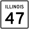
- The heart of the Park District is Deicke Park located just southwest of downtown Huntley, on the west side of Route 47, and south of Main St. This is the village's largest park and one of the larger parks in the local region. Various community events are held here. It features multiple ballfields, picnic shelters, a large slide, playground equipment, basketball and tennis courts, park district offices, and the following major additions adjacent to it:
- a Community Recreational Center housed in the renovated former high school building. It features a large gymnasium, a fitness center, a mess hall, classrooms for workshops and programming, and the Cosman Cultural Arts Center, an auditorium/theater attached to the building.
- Betsey Warrington Park, an extension of the park area when the park district acquired a narrow piece of farmland off of W. Main St. Much of the original farmstead remains intact and remains for historical and recreational use.
- Stingray Bay Aquatic Center, the park district's pool which features a zero depth entrance, water slides, water features, a snack bar, a patio, and locker rooms.
- Ol' Timer's Park, a medium-sized park featuring ballfields and playground equipment, located just off Church St. and near Douglas Ave. in downtown Huntley
- Jim Dhamer Square, the village's town square which features a small gazebo and garden in the heart of the community, renamed for the late Village President.
- Pinecrest Golf Course, a golf course and country club off Algonquin Rd. acquired by the park district in the early 2000s (decade).
- Marvin A. Weiss Park, a medium-sized park located in the Southwind neighborhood, featuring ballfields, playground equipment, and picnic shelters.
- Kiley Park, a smaller park located in Wing Pointe, featuring ballfields, playground equipment, and picnic shelters
- Tures Park, a smaller park located in the Heritage neighborhood, featuring ballfields, playground equipment, and picnic shelters
- Tomaso Sports Park , a sports complex that was dedicated in 2009 to former Village manager Carl Tomaso. The complex features multiple sports fields. It is located on Huntley's far north-side off Ackman Rd.
Other recreational areas
Non-park district related recreational facilities include:
- Whisper Creek Golf Course, a semi-private golf course located within Del Webb's Sun City. There are also many recreational opportunities for residents of Sun City, including all the offerings of the Prairie Lodge, which features two pools, a large lobby and gathering area, the Drendel Ballroom, workshop and programming rooms, exercise equipment, outdoor fountains and lush landscaping, and an on-site restaurant.
- Numerous public areas, marshes, ponds, and open grassy areas within the many subdivisions and neighborhoods of Huntley.
Neighborhoods
Huntley used to be a small town, yet has sprawled out in recent years and gained many new subdivisions. However, there are also distinct neighborhoods built before then which form the core of the old part of Huntley. Both subdivisions and neighborhoods are listed below:

- Del Webb's Sun City, a master-planned community of 6,000 homes for active adults over age 55. Includes two community recreation centers, an 18-hole golf course, numerous recreational areas and facilities, and several neighborhoods and varying housing styles within. Located southwest of downtown Huntley, and having major frontage along I-90 and Route 47. The Kishwaukee River runs through here, and was actually rerouted in parts. A water tower is in the northern part of the development along Main St.
- Talamore, a master-planned community of 2,000 homes by multiple developers under construction on Huntley's far northside, located in the isthmus west of Route 47 and east of Union Rd. Plans are for nearby retail and a large sports complex within.
- Lion's Chase, a neighborhood of about 200 homes located on the western edge of town, south of W. Main St. and north of Del Webb's Sun City.
- Covington Lakes, an upper-middle-class neighborhood of about 500 single-family and townhomes in the northern part of Huntley, northeast of the intersection of Route 47 and Reed Road. Features commercial properties along Route 47 and several lakes within.
- Northbridge, an upper-middle-class neighborhood of about 350 homes in the $250–410K range, located east of town, north of Algonquin Rd., south of Reed Rd., and east of Pinecrest golf course. Includes Faith Community Church.
- Southwind, a middle-class neighborhood of about 700 homes in the easternmost portions of Huntley along Reed and Haligus Roads, and constructed in various phases from about 1997-2003. This subdivision includes a large pond. Largely single family homes, but has an enclave of townhomes as well. Includes one of three Huntley fire stations and a water tower.
- Huntley Meadows, is a younger middle-class neighborhood of about 200 homes on Huntley's northeast side, south of Algonquin Rd. and east of Haligus Rd. Surrounded by Tom's Farm, a popular vegetable market and close to several new churches.
- Georgian Place, a middle-class neighborhood of about 350 homes due east of the old town of Huntley. Located south of Algonquin Rd., east of Ruth Rd., west of Haligus Rd., and north of E. Main St. Features a wetland preserve. Abuts the library and municipal center.
- Heritage/Cider Grove, a middle-class neighborhood of about 600 homes on Huntley's southeast side famous for its colonial design and barn entrance. Located south of E. Main St., north of Huntley Rd., and east of Haligus Rd.
- Wing Pointe, a middle-class neighborhood of about 600 single family homes and townhomes on Huntley's southeast side. Located south of Huntley Rd., and north of Kreutzer Rd. Abuts the massive St. Mary's Catholic Church and a water tower.
- Oak Crest Estates, a very small and exclusive neighborhood of upper middle-class homes on Huntley's far west side along the extension of Algonquin Rd. and along the railroad tracks.
- Huntley Highlands, a very small neighborhood east of Dean St. and abutting the southern edges of the downtown area near Dean Foods and the St. Mary's Cemetery, featuring a mix of ranches and two-stories.
- WoodCreek: a neighborhood of a variety of home styles and including Huntley's largest apartment complex, Woodcreek Apartments.[12]
- North Church Street, an older neighborhood located just north of town between Algonquin and Reed Roads, east of Route 47, featuring predominantly ranch homes and a couple apartment buildings. Abuts the Huntley Center shopping center and the village's first water tower.
- West Main Street, an older neighborhood with a mix of housing styles. Includes predominantly ranch homes on Janice, Bonnie Brae, Sunset, and Lincoln Streets, with old two-story Victorian homes on Main Street. This was in the vicinity of the former Huntley School Campus until the mid-2000s when the elementary school was torn down and the old high school turned into a recreation center.
- Douglas Avenue, a neighborhood just northeast of town with a mix of housing styles, including ranches, two-stories, townhomes, and a few apartments. Abuts Ol' Timers Park.
- Town, the heart of Huntley and featuring the oldest of homes, mainly country and Victorian styles dating back 100 years. Includes Church, Woodstock, Grove, 1st, 2nd, 3rd, Myrtle, Mill, and Dean Streets. Also includes shops, the square, the post office, the American Legion hall, the old fire department, and Trinity Lutheran and First Congregational Churches.
- There are also five neighborhoods west of Downtown Huntley. They are west of the high school, but east of Route 20. The neighborhoods are Botterman Farms, Pebble Creek, Hillsboro Cove, Parkside Crossings, and Knoll Top featuring many nice country-style homes.
Shopping and dining
The village has a growing retail base, offering primarily neighborhood convenience retailers, but is also becoming a significant regional retail area.
Huntley Outlet Center area
The Huntley Outlet Center, owned by Huntley Investment Partners LLC, is a regional outlet mall located north of I-90, at the southeast corner of Illinois Route 47 and Freeman Road.[7] Built in 1994 under the original name "Huntley Factory Shops", it contains primarily brand name clothing and home accessory stores. There are about 50 stores total. An outdoor mall, the mall features lush landscaping, brick walkways, and over-hangs that shield shoppers from the elements. There is also an indoor food court serving as the centerpiece, with a fountain in front and a children's playground in the rear. In the early 2000s, the mall appeared to decline, but has resurrected since the mid-2000s, thanks to a rapidly growing residential base to serve, combined with a makeover, that included new additions to the tenant roster. The Huntley Automall is located in front of the outlet mall, fronting Route 47, and features Tom Peck Ford and a General RV dealership.
Route 47 Corridor
The Route 47 Corridor is also home to the power centers Huntley Grove, Huntley Village Green, and Regency Square, all located on the south end of the corridor in Kane County. All of the centers are planned to be expanded as the Huntley area continues to grow. Smaller neighborhood centers and stand-alone retail buildings are located further north, in addition to the larger community retail plaza Huntley Center, the village's first shopping center. These retail areas are currently home to anchors Walmart Supercenter, Jewel-Osco, Walgreens (2 locations), Wisted's Supermarket, Aldi's and Ace Hardware. Restaurants along the Route 47 corridor include Jameson's, McDonald's 2 locations, Taco Bell, Culver's, Subway (3 locations), Baskin-Robbins/Dunkin' Donuts, Starbucks, Rookie's Bar & Grill, Jimmy John's, Little Caesars, Brunch Café, Papa Saverio's Pizza, Rosati's Pizza, Honey Fluff Donuts, China Palace, Goodfella's Beef, Alvaro's Tacos & Pizza, Jimano's Pizzeria, Dairy Mart, Papa G's, and Starbucks. Banks along Route 47 include Harris Bank 2 locations, Chase Bank, PNC Bank, Citizens Bank, Castle Bank, McHenry Savings Bank, American Community Bank & Trust, TCF Bank, Woodforest Bank, and Wells Fargo. Auto-related services include Auto Zone, Huntley Collision Center, JDM Automotive Services, Fast Eddie's Car Wash, the Huntley Car Wash, Penske Truck Rental, Enterprise Rent-A-Car, and service stations Mobil (2 locations) and 7-Eleven. In addition, Bowl-Hi Lanes is located at the intersection of Route 47 and Algonquin Roads.
Downtown Huntley and other retail areas
Huntley's downtown area, along Main Street, just east of Route 47, includes several shops, restaurants, and bars, centered on Jim Dhamer Square and the village's signature gazebo. Downtown restaurants and/or bars include Sal's Pizza, The Village Inn, Parkside Pub, and Offie's Tap. Strode's Colonial Furniture serves as an anchor for the area. There are also several churches in downtown, in addition to the Post Office, the original fire station, and the American Legion Hall. A small neighborhood center, located southeast of downtown Huntley at the intersection of Huntley-Dundee and Haligus Roads, includes small shops, Snap Fitness, and Higher Grounds coffee shop.
Economy
The village is a haven for industrial businesses, as it is located along the high truck-traffic corridors of Illinois Route 47 and I-90 and a branch of the Chicago & Northwest rail line, and also maintains comparably low taxes, wide open spaces, and equal proximity to Chicago, Rockford, and Wisconsin.
Large businesses present in Huntley include a Weber Grill factory and a new distribution center, a Dean Foods dairy processing and distribution center, Freund International trucking center, Allied Asphalt paving company, and Union Special, an industrial sewing equipment factory. Additional businesses include FYH Bearing and Lionheart. Huntley used to be home to several agribusinesses, such as Marlowe Feed and FS, but as the area has grown and developed, these businesses are no longer in operation.
Huntley also has three industrial business parks, one at the intersection of East Main Street and Ruth Road,another along Kreutzer Road at Smith Road, and Huntley Corporate Park, just off of I-90. Several companies have facilities in these areas.
Transportation
- The village is located along the "Golden Corridor" of Interstate 90/The Northwest Tollway. It has direct access to I-90 via a full interchange at Illinois Route 47. Conversion of the interchange from an eastbound interchange to a full interchange was completed in November 2013.
- Illinois Route 47 serves as the chief north-south artery in Huntley. Handling over 20,000 vehicles a day, Route 47 was expanded from two to five lanes in 2011. Portions of Route 47 between Kreutzer Road and I-90 are six lanes. Route 47 connects to Woodstock to the north and Pingree Grove and Elburn to the south.
- Algonquin Road and Main Street/Huntley-Dundee Road act as the village's primary east-west routes. Algonquin Road is a four-lane divided highway that connects Route 47 to other suburbs to the east like Algonquin and Lake in the Hills. Main Street connects to Marengo and Harmony Roads on the west (leading to U.S. Route 20 and towns like Marengo, Hampshire, and Union), while Huntley-Dundee Road connects to the Carpentersville-Dundee area to the east.
- Other important streets in the village include Ruth Road, Reed Road, Kreutzer Road, Haligus Road, Del Webb Boulevard, and Church Street. Reed and Kreutzer are local east-west roads, while Haligus, Ruth, and Church are local north-south streets. Del Webb Boulevard is the primary collector road in the Sun City neighborhood.
- The village is also located along a branch of the Chicago & Northwestern Railroad, and thus many of the village's industries are near the railroad for convenient access to Elgin, Rockford, Chicago, and essentially the rest of the world.
Festivals/traditions
- Huntley Home & Business Expo, sponsored by the Huntley Chamber of Commerce and other organizations which showcases local businesses and services of all kinds and gives residents and businesses an opportunity for positive interaction. Held in late February.
- Huntley High School Fine Arts Festival, decade long tradition which showcases student artwork as well as musical and dramatic performances. Held in late April.
- Memorial Day: parade through downtown Huntley, where various groups come together and honor veterans who died in wars, and culminating with an honor at the Huntley Cemetery.
- Huntley Town Picnic: running for almost 15 years, held in Deicke Park in late June.
- Fourth of July: fireworks celebration, held at varying locations in recent years.
- Huntley High School Homecoming: parade, held in varying locations over the years, culminating with the Friday football game. Usually in September or October.
- Turkey Testicle Festival: held the day before Thanksgiving at Parkside Pub, usually spreading into the streets of downtown Huntley.
- Summerfest: originated in 2001 for village's sesquicentennial celebration, but has been canceled in recent years. Held by Jaycees group.
- Fall Fest: originated in 2006 and held in September. The Fall Fest is hosted by a volunteer committee under the Huntley Park Foundation.
- Pancake Breakfasts: held in American Legion hall, hosted by the Boy Scouts
- Rummage Sales: occurring all the time at the village's downtown churches, Trinity Lutheran and First Congregational
Local newspapers
- Northwest Herald - daily newspaper based in Crystal Lake which serves the greater McHenry County area.
- Northwest Herald MyHometown - Northwest Herald's Huntley MyHometown homepage.
- Daily Herald - daily newspaper based in Arlington Heights; serves cities in five counties incl. McHenry & Kane
- Huntley Farmside - weekly newspaper edited in St. Charles (Kane Co.), published in Downers Grove.
- Sun Day - Biweekly/Weekly newspaper published by White Silo Media, Inc.; serves the communities of Sun City and Edgewater in Elgin.
- The Voice - critically acclaimed student newspaper of Huntley High School, covering Huntley and surrounding areas, such as Lake in the Hills, Algonquin and Crystal Lake.
Churches


The village has been served for many years, by three churches all located in downtown:
- First Congregational Church, located at Main St. and Church St.
- Trinity Lutheran Church, located on Church St.
- St. Mary Catholic Church, originally located on Woodstock St. As the village has grown, St. Mary's has since moved into a much larger church building built on Huntley-Dundee Rd. on the village's southeast side. The old church building is still occasionally used for special occasions.
As the Village has grown in the 1990s and 2000s, additional churches have sprouted. They include:
- Morning Star Church and World Outreach Center, on Powers Road (near the Del Webb community) since 1994.
- Faith Community Church, at Algonquin Rd. and Haligus Rd.
- Springbrook Community Church, on Algonquin Rd. across from Tom's Farm.
- Shepherd of the Prairie Lutheran Church, which meets at 10805 Main Street
Huntley, IL 60142
- Westlake Community Church, which meets at Cosman Cultural Arts Center
- Willow Huntley, which meets at Huntley High School
- Lighthouse Fellowship Church
References
- 1 2 3 "History of Huntley, Illinois". Huntley Area Public Library. 2010. Archived from the original on December 18, 2006. Retrieved 20 March 2010.
- 1 2 "Huntley village, Illinois - Population Finder". American FactFinder. United States Census Bureau. 2008. Retrieved 20 March 2010.
- 1 2 3 "Huntley village, Illinois - Fact Sheet". American FactFinder. United States Census Bureau. 2000. Retrieved 20 March 2010.
- ↑ "Huntley village" (PDF). Census 2000, Summary File 3. Northeastern Illinois Planning Commission. 16 February 2004. Retrieved 20 March 2010.
- 1 2 U.S. Geological Survey Geographic Names Information System: Village of Huntley
- ↑ "Archived copy". Archived from the original on December 10, 2014. Retrieved October 18, 2015. American FacfFinder, U.S. Census Bureau. Retrieved 28 January 2014.
- 1 2 "Huntley Outlet Center". Simon Property Group. Retrieved 10 April 2015.
- ↑ "G001 - Geographic Identifiers - 2010 Census Summary File 1". United States Census Bureau. Retrieved 2015-08-03.
- ↑ "Annual Estimates of the Resident Population for Incorporated Places: April 1, 2010 to July 1, 2015". Retrieved July 2, 2016.
- ↑ "Census of Population and Housing". Census.gov. Archived from the original on May 11, 2015. Retrieved June 4, 2015.
- ↑ "About Centegra Hospital Huntley". Centegrahospitalhuntley.com. 2016-01-27. Retrieved 2016-03-07.
- ↑ "Woodcreek Arts". Woodcreekhuntley.com. Retrieved 2016-03-07.
External links
- Village of Huntley website
- Huntley Area Public Library
- Huntley Park District
- Huntley Area Chamber of Commerce
- Consolidated School District 158
- Huntley Neighbors
- Huntley Blog
- Miss Huntley Scholarship Pageant
- Huntley Jaycees
Municipalities and communities of McHenry County, Illinois, United States | ||
|---|---|---|
| Cities | ||
| Villages | ||
| Townships | ||
| CDPs | ||
| Other unincorporated communities | ||
| Footnotes | ‡This populated place also has portions in an adjacent county or counties | |
Municipalities and communities of Kane County, Illinois, United States | ||
|---|---|---|
| Cities | ||
| Villages | ||
| Townships |
| |
| CDP | ||
| Other unincorporated communities |
| |
| Footnotes | ‡This populated place also has portions in an adjacent county or counties | |
| Major city |  | |
|---|---|---|
| Cities (over 30,000 in 2010) | ||
| Towns and villages (over 30,000 in 2010) |
| |
| Counties | ||
| Regions | ||
| Sub-regions | ||