Bad Wimpfen
| Bad Wimpfen | ||
|---|---|---|
 | ||
| ||
 Bad Wimpfen | ||
Location of Bad Wimpfen within Heilbronn district 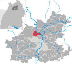 | ||
| Coordinates: 49°14′N 9°10′E / 49.233°N 9.167°ECoordinates: 49°14′N 9°10′E / 49.233°N 9.167°E | ||
| Country | Germany | |
| State | Baden-Württemberg | |
| Admin. region | Stuttgart | |
| District | Heilbronn | |
| Government | ||
| • Mayor | Claus Brechter | |
| Area | ||
| • Total | 19.38 km2 (7.48 sq mi) | |
| Population (2015-12-31)[1] | ||
| • Total | 6,971 | |
| • Density | 360/km2 (930/sq mi) | |
| Time zone | CET/CEST (UTC+1/+2) | |
| Postal codes | 74206 | |
| Dialling codes | 07063 | |
| Vehicle registration | HN | |
| Website | www.badwimpfen.de | |
![]() Bad Wimpfen is a historic spa town in the district of Heilbronn in the Baden-Württemberg region of southern Germany. It lies north of the city of Heilbronn, on the river Neckar.
Bad Wimpfen is a historic spa town in the district of Heilbronn in the Baden-Württemberg region of southern Germany. It lies north of the city of Heilbronn, on the river Neckar.
Geography
Bad Wimpfen is located on the west bank of the River Neckar, around 15 kilometres (9 mi) north of Heilbronn. The town is divided into two parts: the older Wimpfen im Tal (Lower Wimpfen/ literally Wimpfen in the valley) situated on the Neckar, and Wimpfen am Berg (Upper Wimpfen/ literally Wimpfen on the hill) containing the town centre. Besides the town itself, the village Hohenstadt also belongs to Bad Wimpfen.
Neighbouring municipalities
Neighbouring town and municipalities of Bad Wimpfen are (clockwise from the south): Heilbronn, Bad Rappenau, Offenau, Bad Friedrichshall, Untereisesheim and Neckarsulm.
History


First settlement by the Celts
First traces of settlement at Bad Wimpfen date from the Neolithic and the Bronze Age. An old trade road running from France forks here towards Nürnberg and Öhringen linking to the Danube. Several archaeological finds demonstrate that the route has existed since prehistoric times.
Around 450 B.C. the Celtic tribe of the Helvetii settled around the Neckar, Kocher and Jagst including the Bad Wimpfen site. Presumably the Celts had given names to the rivers as they are today. Wimpfen presumably comes from "uimpe" (umwallt) = "surrounded" and "bin" (Berg) = "mountain".
Roman time
It is believed that around 98 A.D. the Romans secured the area in south-western Germany conquered by Domitian (called the Dekumatland) by the Neckar-Odenwald-Limes, a system of castella built every 12 to 15 kilometres (7 to 9 mi). Opposite the Jagst mouth the castellum Wimpfen im Tal was created. Like other places, a civil settlement formed around the castellum containing many traders and manual workers.
After the expansion of the Roman Empire up to the Limes near Jagsthausen arranged by emperor Antonius Pius in 138–161 A.D. the castellum lost its military importance.
All the more important was Wimpfen im Tal as a civil town. It used to be the centre of a district called Civitas Alisinensium and was surrounded by a city wall like just a few Roman towns in today's southern Germany. The surface was about 19 hectare, being one of the biggest Roman towns in today's Baden-Württemberg. Despite this importance the Latin name of the town is unknown today.
Besides, there was a wooden bridge above the Neckar which got destroyed by severe ice occurrence in the early Middle Ages. The origin of a beam salvaged during excavation works in 1957 was proved to be a part of the old bridge. A survey proved the origin to be around 85 A.D.
Development until Middle Ages
After the withdrawal of the Romans the Alamanni governed the Neckar area from 260 A.D. During that time most Roman buildings became dilapidated, since the Alamanni didn't know anything about stone building and how to use Roman infrastructure. Around 500 Wimpfen became part of Franconia. During the settlement of the Franks, according to Clovis I, Christianity was blooming, and today's oldest Christian buildings originate from this time.
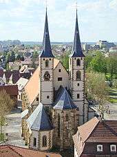
In the 9th century, Wimpfen became part of the Bishopric of Worms and was first mentioned documentary as Wimpina in 829. During that time the Hungarians attacked the region and devastated most settlements including Wimpfen. Within the framework of the following reconstruction the new diocese church St. Peter was built. Being a bigger building, it was dedicated to the patron of the Bishopric of Worms. During more than three centuries the local dioceses performed the jurisdiction there.
Growth of trade
| Imperial City of Wimpfen | ||||||||||
| Reichsstadt Wimpfen | ||||||||||
| Free Imperial City of the Holy Roman Empire | ||||||||||
| ||||||||||
| Capital | Wimpfen | |||||||||
| Languages | South Franconian | |||||||||
| Government | Republic | |||||||||
| Historical era | Middle Ages | |||||||||
| • | City founded | 13th century | ||||||||
| • | Gained Reichsfreiheit | ca 1300 1300 | ||||||||
| • | Battle of Wimpfen | May 6, 1622 | ||||||||
| • | Mediatised to Baden, but annexed by Hesse-Darmstadt | 1802–03 | ||||||||
| • | Renamed Bad Wimpfen | 26 April 1930 | ||||||||
| ||||||||||

In 965 a document dictated by King Otto I granted market rights to Wimpfen. Due to the good location in terms of transport, and catchment area, the market developed significantly. Wimpfen's Talmarkt (valley market) has a history of more than 1000 years and is one of the longest running traditional market events in Germany.
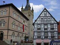
In 1182 Friedrich Barbarossa is believed to have lodged in Wimpfen. He had decentralised the administration of his empire. The Staufers had built Kaiserpfalzen (local castles) across the empire. These were big castles where local lords stayed and jurisdicted. The Pfalz Wimpfen was built on a rocky hill above the settlement of the Neckar valley. The Pfalz and its surrounding settlement grew so strong that it outstripped the older settlement on the Neckar bank. By around 1200 most of the Staufer buildings had been built, including the Blauer Turm (Blue Tower) which is now generally seen as the principal visual landmark of the town. It served as a watch-tower until the 20th century.
The Stauferpfalz of Wimpfen is the biggest preserved one north of the Alps. Its original length was about 215 metres (705 ft), its width about 88 metres (289 ft). Emperor Henry VI h stayed there at least three times; Friedrich II eight times. In 1235 there was a historical meeting between Friedrich II and his rebellious son. Also in the 13th century Richard von Deidesheim arranged a rebuilding of the diocese church into the Gothic style. At the same time a hospital and a Dominican's monastery was founded.
Due to the decline of the Staufers' Empire, Wimpfen became a Reichsstadt, many manual workers settled down and the population grew, establishing a large core of citizens. A town constitution was established, setting an example to many other towns. Many of today's buildings originate from this time.
Emperor Friedrich III. gave the right to hold a second annual market, over and above the established Talmarkt, which was called the Katharinenmarkt. This second market before Christmas also survives in today's Christmas market, and its fame extends over to the whole Baden-Württemberg region.
Times of Reformation
In the 16th century Wimpfen was a focal point of the Reformation. Probably the most important reformer was Erhard Schnepf who preached here from 1523 to 1526. His contemporary Heinrich Vogtherr wrote many reforming essays and hymns. Although the Catholics offered huge resistance to the Reformation, their influence and number decreased. By 1588 there were only 30 Catholic inhabitants. Catholics eventually lost their civil rights and their churches were converted to Protestant use.
Thirty Years' War

This religious conflict soon got less important, since troops of imperial Johann Tserclaes fought against the army of Margrave Georg Friedrich of Baden-Durlach in 1622 nearby the town. This "Battle of Wimpfen" was one of the most important and bloody ones during Thirty Years' War.
During this period Wimpfen was looted several times, and houses and fields were burned. The population decreased radically due to disease and epidemics. At the end of the war, in 1648, the population had been reduced to a tenth of its pre-war size. Many important buildings were destroyed in this period, and redevelopment brought about loss of large parts of the castle which was used for building materials.
The town suffered the devastating consequences of the Thirty Years' War for more than 150 years. Although the Celts had extracted salt since pre-Christian times, there was now no possibility to produce salt. There was huge poverty within the population. During this time the town got financial aid from Nürnberg.
In 1783 it was declared that the removal of wood from surrounding forests was to be taxed to improve the town's financial situation. However, the citizens could not afford these fees. Consequently, there were many riots, but ultimately these were suppressed by local orders.
Originally, in terms of administration, by the Reichsdeputationshauptschluss the town came to Baden. However, the knightly diocese of Wimpfen im Tal came to Hesse-Darmstadt. Consequently, a conflict about sovereignty rights over the diocese increased between Baden and Hesse. Finally Baden agreed to concede the area, since their own territory was far away - and so Wimpfen came to Hesse. This change was officially proclaimed on April 5, 1803. Since 1805/06 Wimpfen was an outlying town under the control of Hesse.
This was a very comfortable situation to Wimpfen, being able to administer itself autonomously. At the time of the foundation of the People's State of Hesse in 1919, Wimpfen became part of the district of Heppenheim. It was fused with the district of Bensheim in 1938, and given the status of Kreis Bergstraße. In total, Wimpfen belonged to Hesse for 140 years. In 1945 the American military government reorganised administrational areas, and Bad Wimpfen came under the control of Baden.
Salt production and bathing
In 1752 the first bore-holes were drilled for salt-water.[2]
In 1817 a permanent salt production works was established. The brine was usually able to be used therapeutically, and in 1835 the first therapeutic hotel opened (Mathilden Spa Hotel). A new economic prosperity began, and a new town hall was built in 1836. Many of the older Staufer buildings were destroyed at this time or fell into disrepair or disuse.
After the opening of the new rail road, running from Heilbronn to Heidelberg, in the 1860s, the spa business increased greatly. Therapeutic baths were expanded more and more, resulting in a major economic growth. Even Mark Twain reported this fact within accounts of his journey through Europe in 1867. On April 26, 1930, the town got its prefix Bad officially.
The town survived World War II almost undamaged, and many refugees came here for accommodation.
Between Hesse and Baden-Württemberg
On September 19, 1945, the American military government proclaimed the foundation of Greater Hesse and Württemberg-Baden. Now the area was completely surrounded by Württemberg-Baden, namely by the districts of Sinsheim and Heilbronn belonging to Baden area of Württemberg. On November 26 the occupying American officials decided to transfer control of Wimpfen to the district of Sinsheim. Eventually the town became a part of Württemberg-Baden legally, this being confirmed by the OLG in Stuttgart on March 6, 1951.
Within the population this decision was not well accepted. Even Hesse demanded a return of its enclave. In a plebiscite vote of April 29, 1951, only 0.7% of the inhabitants voted to stay in the district of Sinsheim. Around 41% voted to return to Hesse, but a majority of 57% decided to change into the district of Heilbronn. This change to Heilbronn was carried out on May 1, 1952.
Despite this result, Hesse continued in its opinion that Bad Wimpfen was a Hessian town. However, it agreed that the newly founded district of Baden-Württemberg should administer the town. This means that the final status of any affiliation remains unclear even today. However, Bad Wimpfen is completely integrated into the administration and jurisdiction of Baden-Württemberg.
Due to its Hessian past, the Catholic Church still belongs as an exclave to the Diocese of Mainz.
Present
In present-day Bad Wimpfen the town is impressive both due to its various spa institutions and due to its numerous fine historic buildings. The historical old part of the town is protected completely. Since 1976 a comprehensive program of redevelopment resulted in an important restoration of most buildings. Due to the recession of the 1990s, private initiatives have now superseded the earlier state interventions, but generally development speed has decreased and settled.
-

older timbering of 1266
-

Bügeleisenhaus
-

half-timbering in the Klostergasse
-

half-timbering in the Badgasse
Religions
Except for a Protestant and Catholic parish in Bad Wimpfen, the town also has a New Apostolic Church and some Jehovah's Witnesses. From 1947 to 2006 the buildings adjacent to the Catholic Church St. Peter housed Grüssau Abbey. This Benedictine monastery, in the district of Heilbronn, containing only three monks in 2005, was eventually closed in the autumn of 2006. Now the remaining monks live in Neuburg Abbey near Heidelberg, Sigmaringen, Kellenried Abbey and Pannonhalma Archabbey.
Formerly there also was a Jewish representation in the town. An early-mentioned Jew who lived in Wimpfen was Alexander ben Salomo, who released the remains of Rabbi Meir of Rothenburg in the early 14th century. Both are buried in Worms. Jews are known to have lived in Wimpfen in the 14th, 15th and 16th century. Around 1550 there was a brief expulsion of Jews. From the 17th century Jewish families lived in at least five houses in Bad Wimpfen, although several orders were passed that discriminated against them—1598, 1630, 1756 and 1762. In 1672 there was an expulsion, cancelled two years later. Jews were given some equality in the years of imperial township, but by 1933 only 22 Jews lived in Bad Wimpfen and they faced increasing discrimination by the Nazi party. The 1938 riots against Jews forced them to leave their homes and businesses. At least four deaths are known to have occurred during this persecution.
-

Protestant church
-

diocese church St. Peter
-

Jewish synagogue of 1580, seized in the 1930s and converted into apartments
-

Jewish graveyard
Politics
District council
Following the municipal election of 13 June 2004, the district council of Bad Wimpfen has 17 seats. The election result is as follows:
| party | amount | +/- | seats | +/- |
| CDU / FW | 49.6% | (+4.8) | 9 | (+1) |
| SPD | 24.8% | (−0.8) | 3 | (−1) |
| FDP / DVP / Unabhängige Bürger (UB) | 16.6% | (+2.0) | 3 | (+1) |
| GRÜNE / Offene Liste (GOL) | 11.4% | (+4.4) | 2 | (+1) |
| Others | 0.0% | (−10.4) | 0 | (−2) |
The mayor is also a member of the district council and its chairman.
Arms and flag

Blazon: In gold the red Eagle of Empire with a horizontal silver key in its beak. The town colours are red, white and blue.
The coat of arms of Eagle and key already appear in Wimpfen's seal of 1250, used until 1436. The eagle was a former symbol of Wimpfen's dependency on the empire in the time of Staufer. Since the 14th century it was the symbol of the free imperial city. The key is both the emblem of Saint Peter and the coat of arms of the Bishopric of Worms. It indicates that the castle was built on communal land of Worms. Over the course of time the key position changed several times.
During the time of the town's Hessian membership a different coat of arms was utilised. However, this was abandoned at the time of the change of administration to Baden.[3]
International relations
Bad Wimpfen is twinned with:
- Servian in the French Département Hérault, since 1967.
- Ödenburg (today's Sopron) in Hungary since 1951, offering the town refuge to their many exiles after World War II.
Culture and sights

Notable buildings
Kaiserpfalz
The most important building in Bad Wimpfen is the Kaiserpfalz. Its most potent remaining symbol is the Blauer Turm (Blue Tower), which was occupied for 650 years. The tower is open to visitors and offers a spectacular panorama over the whole town. The Roter Turm (Red Tower) dating from c.1200 is a second tower of the Pfalz.
-

Steinhaus
-

Palas-Arkadenfenster
-

Schwibbogentor
Historic Churches
The Protestant Stadtkirche was built in the 13th century in Romanesque architecture and ended in Gothic architecture. Next to the church there's the calvary.
The construction of the Dominikanerkirche presumably started in the 13th and ended in the 18th century. The former monastery with artistic cloister contents a school today. The church is used as the Catholic parish church.
The former Johanneskirche was built in the 15th century and rebuilt in 1778. It got secularizated in 1803. By a fire in 1851 the church lost its function, since then the building served as a restaurant.
In the castle quarter on Schwibbogengasse lies the former Jewish synagogue of 1580. This was seized in the 1930s and converted to flats.
The diocese church St. Peter in Wimpfen im Tal, under the control of Grüssau Abbey from 1947 to 2004, presumably goes back to the 7th century. Today's church with its bordering cloister was built in the 13th and 14th century. There was a comprehensive renovation in 2006.
The Cornelienkirche lies east of the centre of Wimpfen im Tal. The building was built in 1476 in the Gothic style has a splendid portal with wall murals. It is believed that Tilly camped here during the Battle of Wimpfen.
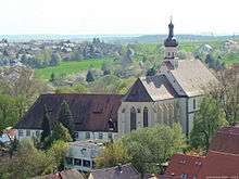
Nearby, the village of Hohenstadt contains an old Protestant parish church.
-

former Dominican monastery, now a school
-

former hospital, now a residential building
-

Cornelienkirche
-

Protestant parish church in Hohenstadt
Secular monuments

- The Bürgerspital (donated around 1230) is one of the oldest half-timbered buildings of the town. Since 1992 it contains the imperial town's museum.
- The Wormser Hof is situated next to the Kaiserpfalz nearby the town hall. The bordering wall behind represents a part of the city wall.
- The Bürgermeister-Elsässer-Haus was built in the shadow of the Blauer Turm in 1717.
- The Nürnberger Türmchen next to the Red Tower was erected in gratitude from the city of Nuremberg for its help in the reconstruction of the heavily damaged city walls after the Thirty Years' War.
- Inside the whole old part of the town there are many half-timbered buildings of the 16th century.
-

Wormser Hof
-

Riesenhaus
-

residential building, 1451
-

Bgm-Elsässer-Haus, 1717
-

Konventshaus, 1765
-

inn
-

further half-timbering
-

Nürnberger Türmchen, 17th century
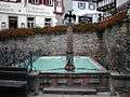
Fountains/wells
-

Löwenbrunnen
-
Adlerbrunnen
-
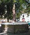
Marktbrunnen
Museums

There are several museums inside the historical old part of the town.
- Museum of Ecclesiastical History, within the Staufen Imperial Palace Chapel (c.1200).
- Museum of History, within the Steinhaus.
- Imperial Town Museum, within the former civic hospital on Langgasse.
- The Odenburg Local Environment Museum set between Langgasse and Hauptstrasse.
Theatre
Since 2003 the Wimpfen open-air shows open-air plays in front of the historical old scenery of the town.
Sports and leisure
In Wimpfen there's a brine bath and an open-air pool. The most successful sports club is the row club of the town.
Regular events
The Talmarkt has taken place since 965. Additionally there is a famous traditional Christmas market.
Economy and infrastructure

One of the biggest employers in Bad Wimpfen is Solvay Fluor GmbH containing more than 350 employees and producing different products in Fluorine chemistry, e. g. refrigerants and propellants. Also many inhabitants are working at the AUDI AG in Neckarsulm.
Transport
Bad Wimpfen station is on the Elsenz Valley Railway (Elsenztalbahn) running from Heilbronn to Heidelberg. The station, dating from 1868[4] is a rare Neo-Gothic style, which many consider to appear Scottish in influence. It contains the local Tourist Information Office. Bad Wimpfen Im Tal and Bad Wimpfen-Hohenstadt halts are on the same line in the municipality. Line S 42 of the Heilbronn Stadtbahn stops at all three stations every half hour.
The town lies near the A 6 (junction Heilbronn/Untereisesheim).
Media
The Heilbronner Stimme (edition north-middle) and the official paper Wimpfener Heimat-Bote report on the happenings of the area.
Education
In Bad Wimpfen there is a primary school, Hauptschule incl. Werkreakschule containing around 380 pupils.
In addition, there is the Hohenstaufen-Gymnasium which has more than 900 students from Bad Wimpfen and its surrounding municipalities.
Health
The urban health centre of Bad Wimpfen (former cure hospital) cares about 4800 patients by a staff of around 200.
Personality
Sons and daughters of the town
- Ignaz von Beecke (1733-1803), composer and pianist
- Carl Walter (1834-1906), architect and director of the Königliche Baugewerkschule in Stuttgart
Other personalities

- Carl Geist (1870-1931), painter
- Paul Doll (1915-2003), mayor of Bad Wimpfen and state representative
References
- ↑ "Gemeinden in Deutschland nach Fläche, Bevölkerung und Postleitzahl am 30.09.2016". Statistisches Bundesamt (in German). 2016.
- ↑ Discover Bad Wimpfen, tourist board publication 2010
- ↑ Heinz Bardua: Die Kreis- und Gemeindewappen im Regierungsbezirk Stuttgart. Theiss, Stuttgart 1987, ISBN 3-8062-0801-8 (Kreis- und Gemeindewappen in Baden-Württemberg, 1). p. 42
Eberhard Gönner: Wappenbuch des Stadt- und des Landkreises Heilbronn mit einer Territorialgeschichte dieses Raumes. Archive direction Stuttgart, Stuttgart 1965 (Publication of the national archive administration of Baden-Württemberg, 9). p. 154ff. - ↑ Discover Bad Wimpfen, local tourist board publication
Literature
- Ludwig Frohnhäuser: Geschichte der Reichsstadt Wimpfen, des Ritterstifts St. Peter zu Wimpfen im Thal, des Dominicanerklosters und des Hospitals zum hl. Geist zu Wimpfen am Berg. Darmstadt 1870, Nachdruck Verein Alt Wimpfen 1982.
- A. von Lorent: Wimpfen am Neckar - geschichtlich und topographisch. Stuttgart 1870, Nachdruck Verein Alt Wimpfen 1982.
- Georg Schäfer: Kunstdenkmäler im Großherzogthum Hessen, Provinz Starkenburg. ehemaliger Kreis Wimpfen. Darmstadt 1898.
- Fritz Arens, Reinhold Bührlen: Wimpfen – Geschichte und Kunstdenkmäler. Bad Wimpfen (Verein Alt Wimpfen) 1954, 1991.
- Rüdiger Jülch: Die Entwicklung des Wirtschaftsplatzes Wimpfen bis zum Ausgang des Mittelalters. W. Kohlhammer, Stuttgart 1961.
- Walter Carlé: Die Geschichte der Salinen zu Wimpfen. Stuttgart (Zeitschrift für Württembergische Landesgeschichte XXIV) 1965
- Albrecht Endriss: Die religiös-kirchlichen Verhältnisse in der Reichsstadt Wimpfen vor der Reformation. Stuttgart (W. Kohlhammer)1967.
- Klaus-Peter Schroeder: Wimpfen. Verfassungsgeschichte einer Stadt. W. Kohlhammer Verlag, Stuttgart 1973.
- Andreas Hafer: Wimpfen. Stadt-Raum-Beziehungen im späten Mittelalter. Stuttgart (W. Kohlhammer) 1993.
- Franz Götzfried (Hrsg.): Salz und Sole in Wimpfen. Beiträge zur Wimpfener Stadt- und Salinengeschichte. Bad Wimpfen 2002.
- Erich Scheible: Die Geschichte der hessischen Exklave Wimpfen. Bd. 1: 1802 bis 1836. Bad Wimpfen (Verein Alt Wimpfen) 2004.
External links
| Wikimedia Commons has media related to Bad Wimpfen. |
- http://www.badwimpfen.de The official website of Bad Wimpfen (in German)
- Bad Wimpfen at DMOZ
- Das Rathaus im Weinbrenner-Stil auf badischewanderungen.de
| Imperial cities |  | |
|---|---|---|
| Nobility | St George's Shield (Gesellschaft von Sanktjörgenschild) | |
| Territories | ||
| Ecclesiastical | 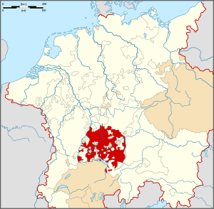 | |
|---|---|---|
| Secular | ||
| Prelates | ||
| Counts Lords |
| |
| Cities | ||
Circles est. 1500: Bavarian, Swabian, Upper Rhenish, Lower Rhenish–Westphalian, Franconian, (Lower) Saxon Circles est. 1512: Austrian, Burgundian, Upper Saxon, Electoral Rhenish · Unencircled territories | ||
Towns and municipalities in Heilbronn (district) | ||
|---|---|---|
| ||