Alata, Corse-du-Sud
| Alata | |
|---|---|
|
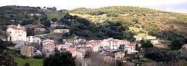
A general view of Alata | |
 Alata | |
|
Location within Corsica region  Alata | |
| Coordinates: 41°58′40″N 8°44′38″E / 41.9778°N 8.7439°ECoordinates: 41°58′40″N 8°44′38″E / 41.9778°N 8.7439°E | |
| Country | France |
| Region | Corsica |
| Department | Corse-du-Sud |
| Arrondissement | Ajaccio |
| Canton | Ajaccio |
| Intercommunality | Pays Ajaccien |
| Government | |
| • Mayor (2008–2020) | Etienne Ferrandi |
| Area1 | 30.37 km2 (11.73 sq mi) |
| Population (2009)2 | 2,955 |
| • Density | 97/km2 (250/sq mi) |
| Time zone | CET (UTC+1) |
| • Summer (DST) | CEST (UTC+2) |
| INSEE/Postal code | 2A006 / 20167 |
| Elevation |
0–782 m (0–2,566 ft) (avg. 450 m or 1,480 ft) |
|
1 French Land Register data, which excludes lakes, ponds, glaciers > 1 km² (0.386 sq mi or 247 acres) and river estuaries. 2 Population without double counting: residents of multiple communes (e.g., students and military personnel) only counted once. | |
Alata is a French commune of France in the Corse-du-Sud department in the Corsica region of France. It is within the metropolitan area of the capital Ajaccio.
The inhabitants of the commune are known as Alatais or 'Alataises[1]
Geography
Alata is 7 km north of the city of Ajaccio and the village is at an altitude of 400m. Alata borders the sea in the Gulf of Lava which is in the Gulf of Sagone. The geographic boundaries of the town are between the Monte Gozzi, the Gulf of Lava, La Punta - Pozzo di Borgo, Ajaccio, Villanova, Appietto and Afa (neighbouring communes) with its 3250 hectares of scrub and large forests of oak.
The commune can be accessed on road D61 north from Ajjacio. The D61 continues through the commune to the north and joins road D81. The D261 road branches west off the D61 to Villanova and the coast west of the commune. The D461 road turns east from the D61 in the commune to access the village of Alata where it terminates. The D81 road traverses the east side of the commune and accesses some of the villages there which have no direct connection with the village of Alata. The coastal portion of the commune is accessed by mountain roads leading off the D61.[2]
Other than Alata village there are a number of other villages in the commune. These are:
- Marina di Lava (on the coast)
- Carbinica
- San Benedettu
- Picchio
- Balisaccia
- Pietrosella
- Tuscia
- Truva
- Rainuchiettu
- Marchesi
- Pruno
- Bellaranda
There are also some built-up areas which have no names.[2]
Neighbouring communes and towns[2]
 |
Appietto | Sarrola-Carcopino | | |
| Mediterranean Sea | |
Afa | ||
| ||||
| | ||||
| Villanova | Ajaccio | Bastelicaccia |
History
The first village was settled close to the Monticchi towers defense post and watchtower, now in ruins but still visible above the present village. Alata has been the seat of the Pozzo di Borgo family since the 16th century.
Administration
List of Successive Mayors of Alata[3]
| From | To | Name | Party | Position |
|---|---|---|---|---|
| 1830 | Gieronimo Casalonga | |||
| 1929 | 1943 | Charles Marie Casa | ||
| 1960 | 1989 | Jérôme Paul Casalonga | ||
| 1989 | 2006 | François Dominic | PRG | |
| 2006 | 2020 | Etienne Ferrandi | PRG |
(Not all data is known)
Demography
In 2009, the commune had 2,955 inhabitants. The evolution of the number of inhabitants is known through the population censuses conducted in the town since 1793. From the 21st century, a census of municipalities with fewer than 10,000 inhabitants is held every five years, unlike larger towns that have a sample survey every year.[Note 1]
| 1793 | 1800 | 1806 | 1821 | 1831 | 1836 | 1841 | 1846 | 1851 |
|---|---|---|---|---|---|---|---|---|
| - | 374 | 311 | 365 | 366 | 413 | 364 | 367 | 359 |
| 1856 | 1861 | 1866 | 1872 | 1876 | 1881 | 1886 | 1891 | 1896 |
|---|---|---|---|---|---|---|---|---|
| 475 | 656 | 481 | 461 | 417 | 435 | 475 | 700 | 648 |
| 1901 | 1906 | 1911 | 1921 | 1926 | 1931 | 1936 | 1946 | 1954 |
|---|---|---|---|---|---|---|---|---|
| 656 | 644 | 643 | 563 | 510 | 552 | 549 | 425 | 462 |
| 1962 | 1968 | 1975 | 1982 | 1990 | 1999 | 2006 | 2010 | - |
|---|---|---|---|---|---|---|---|---|
| 391 | 410 | 452 | 1,132 | 2,077 | 2,462 | 2,785 | 2,955 | - |
Sources : Ldh/EHESS/Cassini until 1962, INSEE database from 1968 (population without double counting and municipal population from 2006)
Economy
- Farming and production of Corsican specialties (Brocciu, figatelli, etc.)
- a hotel in the village
- a large holiday resort located on the sea coast (Marina di Lava)
Culture and heritage
Civil heritage
The Château de la punta (19th century)![]() is registered as an historical monument.[4]
is registered as an historical monument.[4]
Located 600 m above sea level, the chateau offers a panoramic view of Ajaccio up to the entrance of the Gulf of Porto over the surrounding mountains and over Monte Cinto, the highest mountain in Corsica (2706 m).[5]
A replication of one of the pavilions of the Tuileries Palace in Paris that burned down in 1871. When, in 1882, it was decided to completely destroy the Palace in Paris, Jerome Pozzo di Borgo, a great enemy of Napoleon I, acquired a large number of the stones to build a house on the family estate located on the heights of Ajaccio to show his supremacy.
The reconstruction of the castle took place from 1886 to 1894. Unfortunately the castle was burned on 7 August 1978 by a bush fire which spread to the roof causing serious damage. In 1991 the General Council of South Corsica decided on the acquisition of the Château de la Punta and its area of 40 hectares from the Pozzo di Borgo family.
The repair of the roof was completed in 1996 making the castle safe from further damage due to rain. The castle is not yet completely saved however.
The Golfe de Lava is a beautiful Gulf with a holiday village in the commune of Alata where, in 1985, three pieces of Roman gold were found in a fish by three friends. This was the starting point of a fabulous treasure hunt.
Religious heritage
The commune has one religious building that is registered as an historical monument:
- The Pozzo di Borgo Funeral Chapel (19th century).
 [6]
[6] - The Parish Church of Saint-Peter and Saint Paul contains a Tabernacle (17th century)
 that is registered as an historical object:[7]
 - The Parish Church of Saint-Pierre-aux-Liens contains a Tabernacle (17th century) that is registered as an historical object:[8]
Notable People linked to the commune
- Carlo Andrea Pozzo di Borgo
- Jean-Laurent Albertini, a painter originally from Albertacce.
See also
External links
- Alata official website (French)
- Friends of the Château de la Punta website (French)
- Alata on Lion1906
- Alata on Google Maps
- Alata on Géoportail, National Geographic Institute (IGN) website (French)
- Alata on the INSEE website (French)
- INSEE (French)
Notes and references
Notes
- ↑ At the beginning of the 21st century, the methods of identification have been modified by law No. 2002-276 of 27 February 2002 , the so-called "law of local democracy" and in particular Title V "census operations" which allow, after a transitional period running from 2004 to 2008, the annual publication of the legal population of the different French administrative districts. For municipalities with a population greater than 10,000 inhabitants, a sample survey is conducted annually, the entire territory of these municipalities is taken into account at the end of the period of five years. The first "legal population" after 1999 under this new law came into force on 1 January 2009 and was based on the census of 2006.
References
- ↑ Inhabitants of Corse-du-Sud (French)
- 1 2 3 Google Maps
- ↑ List of Mayors of France (French)
- ↑ Ministry of Culture, Mérimée PA00099072 Chateau de la Punta (French)

- ↑ The Friends of the Chateau de la Punta (French)
- ↑ Ministry of Culture, Mérimée PA2A000009 Pozzo di Borgo Funeral Chapel (French)
- ↑ Ministry of Culture, Palissy PM2A000251 Tabernacle (French)
- ↑ Ministry of Culture, Palissy PM2A000058 Tabernacle (French)
| Wikimedia Commons has media related to Alata. |