San-Gavino-di-Carbini
| San-Gavino-di-Carbini | |
|---|---|
|
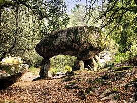
A dolmen in San-Gavino-di-Carbini | |
 San-Gavino-di-Carbini | |
|
Location within Corsica region  San-Gavino-di-Carbini | |
| Coordinates: 41°43′21″N 9°08′54″E / 41.7225°N 9.1483°ECoordinates: 41°43′21″N 9°08′54″E / 41.7225°N 9.1483°E | |
| Country | France |
| Region | Corsica |
| Department | Corse-du-Sud |
| Arrondissement | Sartène |
| Canton | Levie |
| Intercommunality | l'Alta Rocca |
| Government | |
| • Mayor (2008–2014) | Don Pierre Pietri |
| Area1 | 47.88 km2 (18.49 sq mi) |
| Population (2008)2 | 1,018 |
| • Density | 21/km2 (55/sq mi) |
| Time zone | CET (UTC+1) |
| • Summer (DST) | CEST (UTC+2) |
| INSEE/Postal code | 2A300 / 20170 |
| Elevation |
36–1,227 m (118–4,026 ft) (avg. 697 m or 2,287 ft) |
|
1 French Land Register data, which excludes lakes, ponds, glaciers > 1 km² (0.386 sq mi or 247 acres) and river estuaries. 2 Population without double counting: residents of multiple communes (e.g., students and military personnel) only counted once. | |
San-Gavino-di-Carbini is a commune in the Corse-du-Sud department of France on the island of Corsica.
Population
| Historical population | ||
|---|---|---|
| Year | Pop. | ±% |
| 1962 | 373 | — |
| 1968 | 301 | −19.3% |
| 1975 | 266 | −11.6% |
| 1982 | 381 | +43.2% |
| 1990 | 538 | +41.2% |
| 1999 | 738 | +37.2% |
| 2008 | 1,018 | +37.9% |
See also
References
| Wikimedia Commons has media related to San-Gavino-di-Carbini. |
This article is issued from Wikipedia - version of the 1/28/2015. The text is available under the Creative Commons Attribution/Share Alike but additional terms may apply for the media files.