Zlatibor
| Zlatibor | |
|---|---|
| Златибор | |
 | |
| Highest point | |
| Elevation | 1,496 m (4,908 ft) |
| Coordinates | 43°38′53″N 19°40′44″E / 43.648°N 19.679°ECoordinates: 43°38′53″N 19°40′44″E / 43.648°N 19.679°E |
| Geography | |
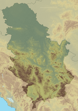 Zlatibor Location in Serbia | |
| Location | Western Serbia |
| Parent range | Dinaric Alps |
Zlatibor (Serbian Cyrillic: Златибoр pronounced [zlǎtibɔːr]) is a mountainous region situated in the western part of Serbia.
Zlatibor is an important tourist area of Serbia, with resources for health tourism, skiing and hiking.[1] The main city of the region is Užice, located at the foothills of the mountain, and most of the area belongs to the municipality of Čajetina. Town of Zlatibor emerged from a group of vacation homes into a full-fledged urban location.
Zlatibor is administratively divided into two municipalities within Serbia: Čajetina and Užice, in the Zlatibor District. The railroad Belgrade-Bar passes through Zlatibor.
History
In the Middle Ages, Zlatibor was known as Rujno, a župa that was part of Raška. The name Zlatibor started to be used in the 18th century, but its etymology is uncertain. It probably stems from the Serbian words zlatni (golden) and bor (pine). Pinus sylvestris var. zlatiborica is a subspecies of pine originating from the mountain, and is endangered today. The hill called Cigla near the village of Jablanica still has some borderline markings of the Kingdom of Serbia, Austria-Hungary and the Ottoman Empire.
Geography
Zlatibor is located in the northern part of the Stari Vlah region, a historical border region between Raška, Herzegovina and Bosnia. It spreads over an area of 300 square kilometres (120 square miles), 43 km (27 mi) in length, southeast to northwest, and up to 37 km (23 mi) in width. Its highest peak Tornik has an elevation of 1,496 m. Zlatibor is situated between 43° 31' N, and 43° 51' N, and between 19° 28' E and 19° 56' E.
The southern and the eastern border of Zlatibor are natural – the rivers Uvac and Veliki Rzav. Villages of Mokra Gora, Semegnjevo and Jablanica mark its western border towards the Tara Mountain. Southern part of Zlatibor, extending towards the Zlatar (mountain) mountain, is referred to as Murtenica.[2]
Tourism

Situated at an elevation of just over 1,000 metres, Zlatibor is a climatic resort, characterized by a cool alpine climate, clean air, long periods of sunshine during the summer and a heavy snow cover in winter. Tourist facilities include modern hotels, holiday centers and cottages, sports grounds and skiing tracks.
Tourist era on Zlatibor officially began on 20 August 1893, when the King of Serbia Aleksandar Obrenović decided to establish a health resort on an initiative from the local hosts. To his honor, a fountain was erected on the place where he had lunch; it was later accompanied by a small lake, titled Kraljeva Voda ("King's water"). In 1945, it was renamed to Partizanske Vode after Yugoslav Partisans, and in 1991 the town received the current name Zlatibor. The area is a location of numerous hotels, villas, restaurants, open swimming pools and other sports facilities. Eventually, residents of surrounding villages of Sirogojno, Gostilje, Jablanica, Rožanstvo, Ljubiš, Tripkova and the town of Čajetina opened their homes to tourists and built other facilities.[1]
Tornik ski resort

Tornik (Serbian Cyrillic: Торник) is the highest peak of Zlatibor, at an altitude 1,496 m (4,908 ft).
Tornik ski resort (Serbian: Ски центар Торник / Ski centar Tornik)[3] is located at elevations between 1,110 and 1,490 m. It has several tracks, four being covered by artificial snowing systems, with the total capacity of the about 5,400 skiers per hour. It is equipped with a six-seater chairlift, carrying 3,000 skiers per hour, and two T-bar ski lifts with total capacity of 2,400 skiers per hour. Along with Kopaonik and Stara Planina, it is one of the most popular resorts in Serbia and western Balkans.
See also
- Ponikve Airport (nearby airport)
References
- 1 2 "Zlatibor Pride Anniversary - 120 Years of Tourism". Tourist Organization of Zlatibor. Retrieved 2016-01-19.
- ↑ Olga Savić. "Geografske odlike Užičkog područja: Reljef" (PDF) (in Serbian). Grad Užice. Retrieved 2016-01-19.
- ↑ "Ski centar Tornik". Ski Resorts of Serbia. Retrieved 2016-01-19.
External links
| Wikivoyage has a travel guide for Zlatibor. |
- Zlatibor in words and pictures Zlatibor.com
- Live cam Tornik ski resort
| Wikimedia Commons has media related to Zlatibor. |
|  | |
(*) indicates location within Kosovo | ||