Užice
| Užice Ужице | ||
|---|---|---|
| City | ||
|
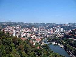
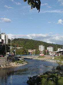
Panoramic view of Užice | ||
| ||
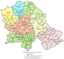
 Location of the municipality of Užice within Serbia | ||
| Coordinates: 43°51′N 19°51′E / 43.850°N 19.850°ECoordinates: 43°51′N 19°51′E / 43.850°N 19.850°E | ||
| Country | Serbia | |
| District | Zlatibor | |
| Settlements | 38 | |
| Government | ||
| • Mayor | Tihomir Petković (SPP) | |
| Area[1] | ||
| • Municipality | 667 km2 (258 sq mi) | |
| Population (2011 census)[2] | ||
| • City | 59,747 | |
| • Municipality | 78,040 | |
| Time zone | CET (UTC+1) | |
| • Summer (DST) | CEST (UTC+2) | |
| Postal code | 31000 | |
| Area code | +381 31 | |
| Car plates | UE | |
| Website |
www | |

Užice (Serbian Cyrillic: Ужице, pronounced [ûʒit͡se]) is a city in western Serbia, located on the banks of the River Đetinja. It is the administrative center of the Zlatibor District. The administrative area has a total population of 78,040, while the city itself has a population of 59,747 (2011 census).[2]
Geography

Užice lies at 411 metres (1,348 feet) above sea level, on both sides of the river Đetinja. The city is completely surrounded by the Dinaric Alps, which are interconnected. 25 kilometres (16 miles) south of the city is Zlatibor mountain, which has a 120-year tradition of tourism.
West of the city are Tara mountains and Zvijezda, which include The National Park with an area of 220 square kilometres (85 square miles) of unspoiled nature.
The Belgrade-Bar railway passes through Užice and connects it with both the northern parts of the country and the Montenegrin coast. Užice has a fairly developed transportation infrastructure, connected with the surrounding areas by state roads of the first order.
History
Ancient era
The region surrounding Užice was settled by Illyrians, specifically the Parthini and Autariatae tribes. Their tombs are found throughout the region. In the 3rd century BC, Scordisci were formed here after the Gallic invasion of the Balkans. The region was conquered by the Roman Empire in 168 BC, being organized into the Illyricum province in 32–27 BC, and after 10 AD, the province of Dalmatia. The town municipium Capedunum existed here during Roman times; its name indicates a Celtic origin (dun, fortress),[3] similar to Singidunum, the founding of Belgrade.
Middle Ages
Slavs have been recorded in the region since the 520s, when tribes pillaged the Eastern Roman Empire; during Justinian I's rule (527–565), up to 100,000 Slavs raided Thessalonica. The region (Drina župania) was part of the Vlastimirović dynasty when they established the Serbian Principality, the first Serb state. Across the Drina, the army of Časlav fought the invading Magyars in ca 950–960. The region was annexed by the Byzantine Empire after 969, becoming part of the katepanate of Ras, then the Theme of Sirmium.
fort built in the 1300s.
The region may have been returned to Serbian hands in the 1040s, during the revolt against the Byzantines led by Stefan Vojislav, progenitor of the Vojislavljević dynasty. In 1083, Vukan and Marko were appointed vassal princes in Rascia. In 1091, Vukan became independent, while Duklja (up until this, the most powerful Serbian principality) slowly crumbled, eventually coming under the rule of Rascia.
The Serbian Grand Principality stayed in the hands of the Vukanović dynasty until another line of the same dynasty was set to rule by Manuel I Komnenos (r. 1143–1180). Zavida, thought to be a brother of Uroš II and Desa, fled after trying to acquire an appanage or the throne itself. Zavida's four sons divided the rule, each holding česti (parts): Stracimir ruled West Morava (including Užice), Miroslav ruled Zahumlje and Travunia, and Stefan Nemanja was given Toplica, Ibar, Rasina and Reke.[4] Stefan Nemanja eventually wrestled the rule when defeating Tihomir in 1171, Stracimir continued ruling in Nemanja's name. The Nemanjić dynasty is named after Nemanja, who began the prospering of Serbia in the Middle Ages.
When King Dragutin abdicated in favor of his brother Milutin, he retained control of Užice region and was given the Mačva region by the Hungarian king, of which he formed the Kingdom of Srem. After King Dragutin died, his lands were annexed to Serbia. The old Fortress on the hill was founded in the mid 14th century. After the death of Emperor Dušan the Mighty, in the period known as the "fall of the Serbian Empire", Užice came under the control of Vojislav Vojinović, a nobleman in the service of Emperor Uroš the Weak. When Vojislav died, his nephew Nikola Altomanović controlled the region. When Uroš died childless, the former Imperial provincial lords begin fighting each other. Serbian Autokrator Lazar Hrebeljanović and Tvrtko I of Bosnia defeated Nikola Altomanović, and divided his lands between themselves. Nikola was blinded in the fortress on the orders of Stefan Musić. Užice came under the control of Lazar, then the Serbian Despotate under his son Stefan Lazarević.
Ottoman period
Užice fell to the Ottoman Turks in 1463, and was part of the Sanjak of Smederevo until 1807, when it was liberated by the Serbian revolutionaries, during the First Serbian Uprising.
Modern Serbia
.jpg)
Užice was the first town in Serbia with a hydroelectric power plant producing alternating current. It was built on the Đetinja river in 1900.
World War II

In 1941, Užice was liberated by the Partizans, who chose it as the capital of the Republic of Užice. This republic was a short-lived military mini-state that existed in the autumn of 1941 in the western part of Nazi-occupied Serbia.
The Republic of Užice comprised almost the whole of western Serbia, with a population of more than 300,000 people. It was located between the Skrapež river in the north, the river Drina in the west, the river Zapadna Morava in the east, and the Uvac river in the south.
In November 1941, the German army re-occupied this territory, while the majority of Partisan forces escaped to Bosnia, Sandžak and Montenegro.
Yugoslav era

Within the former Yugoslavia (established after the Second World War), Užice was renamed "Titovo Užice" (Титово Ужице). From 1992, following the collapse of the pro-communist administration, "Titovo" (meaning Tito's) was removed, leaving the original city name Užice. It was one of eight towns renamed Tito's town in Yugoslavia. Due to being "Titove" and central-planning communist system, Užice received significant amounts of investment in infrastructure and local factories, which made the city one of the most highly developed for its size in former Yugoslavia. Following the break-up of the region, all the towns dropped the "Titove" title.
1990s
During the 1990s Užice's economy shrank rapidly due to war and instability in the region.
In 1999 the city was bombed multiple times during the Operation Allied Force. The largest scale bombing occurred on May 6, 1999 when NATO forces bombed many roads and highways, the airport, civilian buildings and government buildings.[5] After this, thousands of people turned out at the city's main square to protest the bombings and destruction of the city and killings of civilians.
Settlements
Apart from the city, the municipality of Užice includes the following settlements (population per 2011 census given in brackets):[2]
|
The town of Sevojno, located 5 km east of Užice, voted to become a separate urban municipality within the city. As of 2013 negotiations are still under way.[6]
Economy
The city has a developed textile, leather, machine and metal industry. Most companies have decided to build their factories on the outskirts of the city due to good communication connections, notably the close proximity of the main highway, railroad and airport.
The Prvi Partizan ammunition factory was established in 1928. At first the company carried the name 'FOMU'. Today, Prvi Partizan makes over 350 types of ammunition, and is an important partner of Zastava Arms. The company is partially located in a hill that overlooks the city.
Užice-Ponikve Airport is currently under reconstruction, and as a result cargo airlines will mostly use it for transporting goods. The airport management confirmed interest in low cost, scheduled and chartered airlines.
Užice had always been a relatively well developed city in the former Yugoslavia. In 1981 Užice's GDP per capita was 157% of the Yugoslav average.[7]
Culture
The library and theater are in the main square in the city center. Also located in the area are newspaper agencies, radio and television stations and publishing companies. The city gallery is in the lowlands of Pašinovac, the oldest area of the city. The national museum displays cultural and historical treasures of the city, and with its exhibitions, shows the centuries of rich Užice history. It is located on the Eastern side of the main city street.
The Gymnasium of Užice is one of the oldest high school institutions in Serbia. Beside the gymnasium, there are also several other primary and secondary schools and faculties located in Užice.
Milutin Uskoković, writer from Užice, was described as the author of the first modern novel in Serbia.
The locals, Užičans (Serbian: Ужичани, Užičani), have their own traditional costume, and folk music; the sound of which is transitional between the music of Šumadija (central Serbia) and Bosnia and Herzegovina. They speak a Neo-Štokavian Užican dialect, originally with Ijekavian pronunciation.
Architecture

Some distinctive buildings in Užice are:
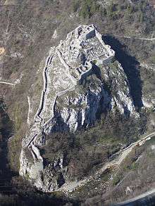
- Old Town-fortress, 14th-century fortress
- St. George's Cathedral
- Building of the Municipality of Užice
- Užička gimnazija (The Užican Gymnasium)
- Jokanovića kuća (The House of Jokanovićs, one of the oldest buildings in Užice)
Media
Užice is turning into the regional media center of western Serbia.
- TV stations: TV5 Užice, TV Alfa, TV Lav, TV SOS
- Radio stations: Radio Užice, Radio 31, Radio Luna, Radio Delfin, Radio Lav, Radio SOS
- Newspapers: Vesti, Užička nedelja
International relations
Twin towns / sister cities
Užice is twinned with:
Demographics
Ethnic composition of the municipality:
| Ethnic group | Population |
|---|---|
| Serbs | 76,089 |
| Montenegrins | 144 |
| Yugoslavs | 80 |
| Roma | 70 |
| Croats | 69 |
| Others | 1,588 |
| Total | 78,040 |
Notable people
- Politicians
- Ljubomir Kaljević (1841–1907), former Prime Minister of Serbia
- Nikola Ljubičić (1916–2005), national hero, General of the Army, Defence minister, President of the Presidency of Serbia, born in Karan (Užice municipality)
- Slobodan Penezić Krcun (1918–1964), national hero, Interior minister
- Dragoljub Ojdanić (b. 1941), former Chief of the General Staff and Defence minister, convicted of deportation and forcible transfers by the ICTY, born in Ravni (Užice municipality)
- Nataša Mićić (b. 1965), MP, former President of the National Assembly of Serbia and acting President of Serbia
- Nikola Selaković (b. 1983), Minister of Justice and Public Administration
- Sportspeople
- Milovan Đorić (b. 1945), football coach and former footballer, born in Bioska (Užice municipality)
- Milan Radović (b. 1952), former footballer, Yugoslav First League top goalscorer (1980–81)
- Srboljub Stamenković (b. 1956), former footballer
- Vladan Vićević (b. 1967), football coach and former Salvadoran international footballer
- Zoran Njeguš (b. 1973), football coach and former footballer
- Radiša Ilić (b. 1977), former footballer
- Nemanja Vidić (b. 1981), Serbia international footballer, winner of 5 Premier League titles and the UEFA Champions League (2008) with Manchester United
- Miloš Marić (b. 1982), Serbia and Montenegro international footballer
- Nenad Novaković (b. 1982), footballer
- Branimir Petrović (b. 1982), footballer
- Filip Arsenijević (b. 1983), footballer
- Filip Kasalica (b. 1988), Montenegro international footballer
- Miroslav Radošević (b. 1973), former basketball player
- Nikola Otašević (b. 1982), basketball player
- Milovan Raković (b. 1985), basketball player
- Dušan Katnić (b. 1989), basketball player, U19 world champion (2007)
- Vesna Čitaković (b. 1979), volleyball player
- Nataša Krsmanović (b. 1985), volleyball player, European champion (2011)
- Ana Antonijević (b. 1987), volleyball player
- Tijana Malešević (b. 1991), volleyball player, European champion (2011)
- Olivera Jevtić (b. 1977), long-distance runner
- Mirko Petrović (b. 1981), middle and long-distance track athlete
- Andrija Zlatić (b. 1978), sports shooter, two-time European champion, two-time World vice-champion and Olympic medalist (2012)
- Others
- Rudolph Reti (1885–1957), musical analyst, composer and pianist
- Vladimir Anić (1930–2000), Croatian linguist
- Ljubomir Simović (b. 1935), poet and writer
- Slavko Vukosavljević (1927-2004), philologist and journalist, author of the famous poem "Kadinjača" (1950)
- Đorđe Prudnikov (b. 1939), Russo-Serbian painter, graphic artist and designer
- Steve Tesich (1942–1996), born Stojan Tešić, Serbian-American screenwriter, playwright and novelist, Academy Award winner for Best Original Screenplay (1979)
- Ljubomir Ljubojević (b. 1950), chess Grandmaster
- Milivoje Kostic (b. 1952), Serbian-American thermodynamicists and professor emeritus of mechanical engineering at Northern Illinois University
- Oliver Mandić (b. 1953), rock musician, composer and producer
- Ivan Bosiljčić (b. 1979), actor
- Oliver Jezdić, former member of Serbian popular rock band Galija
References
- ↑ "Municipalities of Serbia, 2006". Statistical Office of Serbia. Retrieved 2010-11-28.
- 1 2 3 "2011 Census of Population, Households and Dwellings in the Republic of Serbia: Comparative Overview of the Number of Population in 1948, 1953, 1961, 1971, 1981, 1991, 2002 and 2011, Data by settlements" (PDF). Statistical Office of Republic Of Serbia, Belgrade. 2014. p. 178. ISBN 978-86-6161-109-4. Retrieved 2014-06-27.
- ↑ p. 340
- ↑ p. 31
- ↑ Warfacts.org.yu (1999). "(NATO Aggression) Civilian Infrastructure: Uzice". Archived from the original on 2007-12-04. Retrieved 2007-05-14.
- ↑ "Ekonomske dileme i decentralizacija u praksi" (in Serbian). Danas. 24 February 2013.
- ↑ Radovinović, Radovan; Bertić, Ivan, eds. (1984). Atlas svijeta: Novi pogled na Zemlju (in Croatian) (3rd ed.). Zagreb: Sveučilišna naklada Liber.
External links
| Wikimedia Commons has media related to Užice. |
- (Serbian) City of Užice
- (Serbian) uzice.net - history, culture, tourism, sports, living, economy and everything else about Užice
- (Serbian) Web portal of Užice's region – news, interactive map of Užice, events, discussion boards, weather
- (Serbian) The official Facebook page of Uzice city