Vlasina Lake
| Vlasina Lake | |
|---|---|
 | |
| Location | Southeast Serbia |
| Coordinates | 42°42′N 22°20′E / 42.700°N 22.333°ECoordinates: 42°42′N 22°20′E / 42.700°N 22.333°E |
| Type | reservoir |
| Primary outflows | Vlasina River |
| Basin countries | Serbia |
| Max. length | 10.5 km |
| Max. width | 3.5 km |
| Surface area | 16 km² |
| Average depth | 10.3 m |
| Max. depth | 34 m |
| Water volume | 0.165 km³ |
| Surface elevation | 1211 m |
| Frozen | Occasionally |
| Islands | 2 permanent |
Vlasina Lake (Serbian: Власинско језеро, Vlasinsko jezero) is a semi-artificial lake in Southeast Serbia. Lying at an altitude of 1,211 metres (3,973 ft), with an area of 16 square kilometres (6.2 sq mi), it is the highest and largest artificial lake in Serbia. It was created in 1947–51 when the peat bog Vlasinsko blato (Vlasina mud) was closed off by a dam and submerged by the waters of incoming rivers, chiefly the Vlasina.
Geography
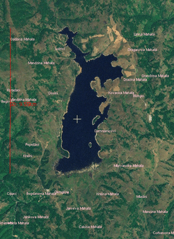
The lake lies at 42°42′N 22°20′E / 42.700°N 22.333°E on a plateau called Vlasina in the municipalities of Surdulica and Crna Trava.[1] The plateau is surrounded by the mountains of Čemernik, Vardenik and Gramada.[2] The lake runs North-South for a length of about 9.5 kilometres (5.9 mi) and has a maximum width of approximately 3.5 kilometres (2.2 mi). Its average depth is 10.5 metres (34 ft) and its maximum depth is 34 metres (112 ft), near the dam.
The central part of the lake is wide and 10 and 15 metres (33 and 49 ft) deep. Its eastern coastline is jagged, with two bays: larger Biljanina bara and smaller Murin zaliv separated by Taraija peninsula. The southern part of the island, between Bratanov del peninsula and the mouth of Božićki kanal is shallower (2 to 6 metres or 6.6 to 19.7 feet), with swampy coasts and peat.
The dam is located in the northwestern part of the lake. It is an embankment dam, built of a concrete core with an earth-filled cover. Construction ran from 1946 to 1948, when the reservoir was first filled. It is 239 metres (784 ft) long, 139 metres (456 ft) wide at the base and 5.5 metres (18 ft) at the top, and 34 metres (112 ft) high (of which 25.7 metres or 84 feet is above the ground). The reservoir it creates has a volume of around 1.65 cubic kilometres (0.40 cu mi). Of these, 1.05 cubic kilometres (0.25 cu mi) is usable for hydroelectric exploitation. The system of 4 hydroelectric plants called Vrla (I-IV) lies downstream of the lake, on the Vlasina River, with a total capacity of 125 megawatt-hours (450 GJ).[3] A part of the hydroelectric system is the pump station "Lisina", which pumps in water from the nearby Lisina Lake, chiefly in summer months. Vlasina Lake is also fed by numerous streams, descending from the surrounding mountains. The water level varies, depending on the water influx and drainage of the dam. Two artificial canals enter the lake near the dam: Čemernički kanal from the west and Strvna from east.
The lake is most easily accessible from the southwestern side, by a 19 kilometres (12 mi) long section of the M1.13 road from Surdulica, which itself lies 10 kilometres (6.2 mi) east of the Niš-Skopje motorway on the E75 European Route. The road extends west, towards the Bulgarian border crossing at Strezimirovci, some 20 kilometres (12 mi) away. Along the west shore, the regional road R122 leads across the dam towards Crna Trava in the north.[4]
Islands
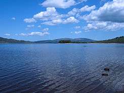
There are two permanent islands on the lake, along its eastern coast: Dugi del (7.84 hectares or 19.4 acres) and Stratorija (1.82 hectares or 4.5 acres).[1] Along with those islands, one of the lake's most famous features are the floating islands, occurring when at high water level loose chunks of peat 0.5 to 2 metres (1 ft 8 in to 6 ft 7 in) thick break off the shore. Driven by the wind, they float from one shore of the lake to another, carrying the flora and fauna, and serving as shelter and a food source for fish. For that reason, they are an attractive target for fishermen. The largest such island has an area of 8 hectares (20 acres), and is referred to as "Moby-Dick" by the local population. It is overgrown with dense vegetation, including birch trees. However, most of the time it is anchored along the shore.

Water
The temperature of the water reaches 21 to 23 °C (70 to 73 °F) in the summer months,[5] making for refreshing swimming. It freezes in the winter and the ice crust can be as much as 2 metres (6 ft 7 in) thick.[6] The temperature also varies with location and depth. In the village of Topli Do south of the lake, there is a water factory "Vlasinka", producing high-quality mineral water called "Vlasinska Rosa", a renowned brand in Serbia. It was purchased by The Coca-Cola Company in 2005.[7]
Biodiversity and protection

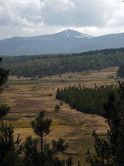
The lake's flora and fauna are rich, and include several endemic species. It features over 850 species of flora and over 180 species of vertebrates, including rare species of mammals, reptiles and amphibians.[1] The lake's surroundings are a mixture of meadows and high-altitude forests, especially birch, beech, pine and juniper (the former two indigenous, and the latter chiefly introduced by afforestation of the western shore). The indigenous trees downy birch and yellow beech (characteristic for its ever-yellow leaf color) stand out among the species of trees. Sundew is the only carnivorous plant in Serbia and is unique to the Vlasina region. Birdlife includes gray heron, tufted duck and cormorant.[2]
The lake is home to numerous species of fish. These include brown and Ohrid trout, perch, minnow, barbel, grass carp, common carp, crucian carp, tench, roach and others. Ohrid trout was stocked and it successfully adapted to the environment, making it a popular for fishing.
By the decision of Government of Serbia in 2006, the Vlasina region is protected as a nature preserve of special interest at category I. The total protected area is 12,741 hectares (31,480 acres), of which 9.6 hectares (24 acres) are in the 1st level of protection (islands of Dugi Del and Stratorija), 4,354 hectares (10,760 acres) in the 2nd level and 8,377 hectares (20,700 acres) in the 3rd level of protection.[1]
Tourism
Current tourist capacity includes around 300 beds in hotels "Vlasina" and "Narcis", offering a modest range of services.[8] Along with regular tourists, they often host sporting teams from Serbia and abroad, as the lake is a popular destination for summer training due to its high altitude. Sporting grounds include a large football field, small sports field and weightlifting room.
An ambitious project for development of tourism is planned for the Vlasina area by the country's Development plan and the Ministry of Tourism, and it is included in the "21 projects for the 21st century" plan. The planned facilities include a new tourist center Novi Rid, with 1000 beds and shopping center, tourist center Krstinci with 350 beds, center "Džukelice" for summer sports, a marina for sailboats (motorboats are forbidden on the lake[6]), a number of ski lifts and facilities for Nordic skiing.
See also
References
- 1 2 3 4 Ministry of Environmental Protection of Republic of Serbia (2006-04-11). "Uredba o zaštiti Predela izuzetnih odlika "Vlasina"" (PDF) (in Serbian). Official Gazette of Republic of Serbia.
- 1 2 "Vlasinsko jezero" (in Serbian). Turistička organizacija Srbije.
- ↑ "Economic Association "Hydro Power Plants Djerdap", plc". Elektroprivreda Srbije. Retrieved 2010-10-19.
- ↑ "Serbia Main and Regional Road network map" (PDF). Public Utility "Roads of Serbia".
- ↑ "Klub putnika Srbije:Vlasinsko jezero" (in Serbian).
- 1 2 Žaklina Milenković (2005-02-21). "Ploveća ostrva - svetski fenomen" (in Serbian). Glas javnosti.
- ↑ "Serbian president attends takeover of "Vlasinka"". Tanjug. 2005-06-06.
- ↑ "Nastava u prirodi: Vlasinsko jezero" (in Serbian). Unico Travel agency. Retrieved 2010-12-01.
External links
- http://www.netbre.info/vlasina
- Photo of the floating islands
- A mushroom collector's image gallery (Serbian)
| Wikimedia Commons has media related to Vlasina Lake. |