Wool Bay, South Australia
| Wool Bay South Australia | |||||||||||||
|---|---|---|---|---|---|---|---|---|---|---|---|---|---|
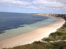 View of Wool Bay and jetty from the cliff top | |||||||||||||
 Wool Bay | |||||||||||||
| Coordinates | 34°59′30″S 137°45′30″E / 34.99167°S 137.75833°ECoordinates: 34°59′30″S 137°45′30″E / 34.99167°S 137.75833°E | ||||||||||||
| Population | 608 (2006 census)[1] | ||||||||||||
| Established | 1872[2] | ||||||||||||
| Location |
| ||||||||||||
| LGA(s) | Yorke Peninsula Council | ||||||||||||
| State electorate(s) | Goyder[3] | ||||||||||||
| Federal Division(s) | Grey[4] | ||||||||||||
| |||||||||||||
| Footnotes | Adjoining localities[5] | ||||||||||||
Wool Bay (formerly Pickering) is a locality and a former government town in the Australian state of South Australia on the east coast of southern Yorke Peninsula. It is located between Stansbury and Coobowie on the Yorke Peninsula, approximately 220 kilometres from Adelaide by road.
History
Originally called Pickering when it was established in 1872, the town is built on cliffs overlooking a protected bay. In 1882 a jetty was built. Wide enough to roll wool bales out to the ships, the locals came to know the jetty as Wool Bay jetty and by 1940, the name of the town had also changed to Wool Bay.[6] For many years, the town functioned as a wool, grain and lime exporting port.
History of lime burning at Wool Bay
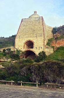
Between 1900 and 1910, six lime kilns were built on top of, and along the base of, the rugged cliffs overlooking the bay. Lime was burnt to create quicklime, an important ingredient in mortar and brick-making. Today, the ruins of only one kiln remain. Perched precariously on the side of the cliff, or so it seems when looking up from the jetty, this kiln was the cutting edge of wood-fired lime burning technology when it was built by Mr Miller from David Miller & Sons, and opened in 1910.[7] Technological changes and a decrease in the demand for lime during the 1950s and 1960s led to the closure of the Wool Bay kilns. Most of the remaining kilns and supporting infrastructure were demolished in the 1970s. Today, the town of wool bay is popular with holiday makers. The beach of Wool Bay features a permanently moored pontoon which is maintained by the local progress association, several sun shelters and a cement boat ramp. A number of marine animals inhabit the waters of Wool Bay; dolphins and stingrays rays can frequently be seen close to shore, and fur seals often feed off the rocky outcrop between the second and third coves past the main bay in the early evening.
Wool Bay jetty
Community lobbying for a jetty commenced in 1879: the people believed that deep water in the bay would provide safer anchorage than other nearby locations. Eventually in 1882 construction of a jetty was undertaken by Frank George. Originally 155 metres long, it provided a depth of 2.1 metres at low tide. When lime burning became an established industry at Wool Bay the jetty was extended by a further 18 metres in anticipation of increased use. During this time, a steamship service dropped off and picked up provisions three times a week. When bulk-handling of grain was introduced at Port Giles in 1970, Wool Bay's importance as a port dwindled.
Today, the jetty at Wool Bay is popular with anglers. It is known for producing good catches of Squid and tommies throughout the year while Garfish, Mullet and Snook and other species can be caught in season. The jetty is also used by recreational scuba divers, drawn by the population of leafy sea dragons that can be found inhabiting the waters beneath the jetty.
Governance
Wool Bay is in the Yorke Peninsula Council, the South Australian House of Assembly electoral district of Goyder and the Australian House of Representatives Division of Wakefield.[3][4][5]
See also
References
- ↑ Australian Bureau of Statistics (25 October 2007). Wool Bay (State Suburb). 2006 Census Quickstats. Retrieved on 2008-05-29
- ↑ "Search result for "Wool Bay (Locality bounded) " (Record no. SA0024099) with the following layers selected - "Suburbs and Localities" and " Place names (gazetteer)"". Property Location Browser. Government of South Australia. Retrieved 23 June 2016.
- 1 2 "Goyder electorate boundaries as of 2014". ELECTORAL COMMISSION SA. Retrieved 23 July 2015.
- 1 2 "Federal electoral division of Grey" (PDF). Australian Electoral Commission. Retrieved 24 July 2015.
- 1 2 "New Ward Structure 2014". Yorke Peninsula Council. Retrieved 21 October 2015.
- ↑ "NEW TOWN NAMES APPROVED". Chronicle. LXXXIII, (4,728). South Australia. 1 August 1940. p. 13. Retrieved 31 August 2016 – via National Library of Australia.
- ↑ "WOOL BAY LIME. NEW KILN ESTABLISHED". The Advertiser. Adelaide. 13 August 1910. Retrieved 1 April 2016.
| Wikimedia Commons has media related to Wool Bay, South Australia. |
| Major Townships | |||||||||||
|---|---|---|---|---|---|---|---|---|---|---|---|
| Minor Townships | |||||||||||
| Governance |
| ||||||||||
| Coastal features | |||||||||||
| Protected areas |
| ||||||||||
| Islands adjoining the Yorke Peninsula coast | |||||||||||
| Related and uncategorised | |||||||||||
| |||||||||||