Stenhouse Bay, South Australia
| Stenhouse Bay South Australia | |||||||
|---|---|---|---|---|---|---|---|
 | |||||||
 Stenhouse Bay | |||||||
| Coordinates | 35°17′0″S 136°56′0″E / 35.28333°S 136.93333°ECoordinates: 35°17′0″S 136°56′0″E / 35.28333°S 136.93333°E | ||||||
| Established | 1920 | ||||||
| Postcode(s) | 5575[1] | ||||||
| Time zone | ACST (UTC+9:30) | ||||||
| • Summer (DST) | ACST (UTC+10:30) | ||||||
| Location | 156 km (97 mi) from Adelaide city centre[1] | ||||||
| LGA(s) | Yorke Peninsula Council | ||||||
| State electorate(s) | Goyder[2] | ||||||
| Federal Division(s) | Grey[3] | ||||||
| |||||||
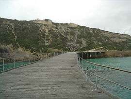
The township of Stenhouse Bay is at the western tip of Yorke Peninsula in South Australia. It was named after Andrew Stenhouse, who in the 1920s had a business called the Permascite Manufacturing Company. He helped start the gypsum industry in this location.
The Waratah Gypsum Company had works here for the quarrying and exporting of rock gypsum. Gypsum after being washed, roasted and ground, was used in the manufacturing of plaster of paris and cement. The quality of the gypsum in this area was exceptionally high class and most of Australia's needs were supplied from here.
The Waratah Gypsum Company closed its works and the town was sold to the South Australian Government which demolished the town except for the few houses required for the rangers of the National Parks and Wildlife Organization who look after Innes National Park.
Climate
| Climate data for Stenhouse Bay | |||||||||||||
|---|---|---|---|---|---|---|---|---|---|---|---|---|---|
| Month | Jan | Feb | Mar | Apr | May | Jun | Jul | Aug | Sep | Oct | Nov | Dec | Year |
| Record high °C (°F) | 44 (111) |
44 (111) |
41.2 (106.2) |
36.2 (97.2) |
29.8 (85.6) |
25.8 (78.4) |
20.5 (68.9) |
27 (81) |
30.7 (87.3) |
35.2 (95.4) |
39.9 (103.8) |
41.3 (106.3) |
44 (111) |
| Average high °C (°F) | 25.1 (77.2) |
24.9 (76.8) |
23.3 (73.9) |
21 (70) |
18.7 (65.7) |
16.3 (61.3) |
15.5 (59.9) |
16.3 (61.3) |
18.2 (64.8) |
20 (68) |
22 (72) |
23.1 (73.6) |
20.4 (68.7) |
| Average low °C (°F) | 16.7 (62.1) |
17.1 (62.8) |
16 (61) |
14.1 (57.4) |
12.1 (53.8) |
10.2 (50.4) |
9.2 (48.6) |
9.4 (48.9) |
10.5 (50.9) |
11.7 (53.1) |
13.7 (56.7) |
15 (59) |
13 (55) |
| Record low °C (°F) | 11.3 (52.3) |
11.1 (52) |
10.1 (50.2) |
6.8 (44.2) |
4.8 (40.6) |
−3.5 (25.7) |
3.4 (38.1) |
2.9 (37.2) |
4.2 (39.6) |
5 (41) |
8.1 (46.6) |
8.6 (47.5) |
−2.9 (26.8) |
| Average rainfall mm (inches) | 12.8 (0.504) |
16.5 (0.65) |
22.2 (0.874) |
27.8 (1.094) |
52.7 (2.075) |
73.4 (2.89) |
68.2 (2.685) |
57.9 (2.28) |
43.9 (1.728) |
29.2 (1.15) |
21.3 (0.839) |
17.1 (0.673) |
443 (17.442) |
| Average rainy days | 4.3 | 3.6 | 6.2 | 9.3 | 15.4 | 18.4 | 19.4 | 19 | 14.9 | 9.7 | 7.3 | 6.6 | 134.1 |
| Source: Bureau of Meteorology[4] | |||||||||||||
Innes Park Trading Post and Rhino's Tavern
After almost 60 years, the shop at Stenhouse Bay, trading in recent years as Innes Park Trading Post and Rhino’s Tavern, was demolished before Christmas in 2013.
The iconic trading post and tavern was closed and fenced off just before the peak Christmas period. Park visitors must now travel 5km out of the park back to Marion Bay for fuel, camping goods and a restaurant meal. The closure meant the department lost between $30,000 and $50,000 in annual lease revenue.
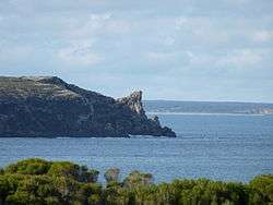 Rhino Head at the eastern end of Stenhouse Bay
See also
References
- 1 2 "Stenhouse Bay, South Australia". Postcodes Australia. Retrieved 26 July 2015.
- ↑ "Goyder electorate boundaries as of 2014". ELECTORAL COMMISSION SA. Retrieved 23 July 2015.
- ↑ "Federal electoral division of Grey" (PDF). Australian Electoral Commission. Retrieved 24 July 2015.
- ↑ "Stenhouse Bay". Climate statistics for Australian locations. Bureau of Meteorology. January 2015. Retrieved 27 January 2015.
| Wikimedia Commons has media related to Stenhouse Bay, South Australia. |
| Major Townships | |||||||||||
|---|---|---|---|---|---|---|---|---|---|---|---|
| Minor Townships | |||||||||||
| Governance |
| ||||||||||
| Coastal features | |||||||||||
| Protected areas |
| ||||||||||
| Islands adjoining the Yorke Peninsula coast | |||||||||||
| Related and uncategorised | |||||||||||
| |||||||||||