Westlake, Texas
| Town of Westlake, Texas | |
|---|---|
| Town | |
| Motto: "A premier knowledge-based community." | |
 Location of Westlake in Tarrant County, Texas | |
| Coordinates: 32°58′57″N 97°12′20″W / 32.98250°N 97.20556°WCoordinates: 32°58′57″N 97°12′20″W / 32.98250°N 97.20556°W | |
| Country |
|
| State |
|
| Counties | Tarrant, Denton |
| Settled | 1847 |
| Incorporated | 1954 |
| Government | |
| • Type | Council-Manager |
| • City Council |
Mayor Laura Wheat Alesa Belvedere Michael Barrett Wayne Stoltenberg Carol Langdon Rick Rennhack |
| • Town Manager | Tom Brymer |
| Area | |
| • Total | 6.7 sq mi (17.3 km2) |
| • Land | 6.6 sq mi (17.1 km2) |
| • Water | 0.1 sq mi (0.2 km2) 1.35% |
| Elevation | 574[1] ft (175[2] m) |
| Population (2010) | |
| • Total | 992[3] |
| • Density | 104.77/sq mi (40.57/km2) |
| Time zone | CST (UTC-6) |
| • Summer (DST) | CDT (UTC-5) |
| ZIP code | 76262 |
| Area code(s) | 817/682 |
| FIPS code | 48-77620[4] |
| GNIS feature ID | 1379259[5] |
| Website | The Town of Westlake, Texas |
Westlake is a town in Denton and Tarrant Counties in the U.S. state of Texas and an upscale suburb of Fort Worth. The population is 702 as of the 2010 United States Census.
History
The area known as Westlake was originally settled in 1847 by Charles and Matilda Medlin with about 20 other families. In the mid-twentieth century, what is now Westlake was known as Circle T Ranch, a 2,000 acre ranch founded by Dallas attorney and oilman J. Glenn Turner. When incorporated in the late 1950s, the name Southlake, Texas already existed, so ranchers and homeowners took the name Westlake.[6]
During the late 1990s, the City Council attempted to disband the city. The large Solana development was annexed by Southlake, while several large tracts of land were annexed by Fort Worth, Texas. A local district judge ruled the annexations in violation of state law, and the properties returned under Westlake jurisdiction.[7]
In 2000, the radio program This American Life featured a story about the battle to disband the town in the face of development by Ross Perot, Jr..[8]
Westlake is known for having by far the highest per-capita revenue from traffic tickets of any town in Texas.[9] Interestingly, the city does not provide its own police force. Instead, law enforcement services are contracted from the City of Keller, which provides patrol and traffic enforcement officers to serve Westlake. The city does, however, provide its own fire and EMS services.
Westlake styles itself as the "Town of Westlake," but this is technically incorrect - under Texas law, all incorporated places, regardless of size or population, are considered "cities". The official name of the town in government documents is therefore "City of Westlake".
Geography
Westlake is located at 32°58′57″N 97°12′20″W / 32.98250°N 97.20556°W (32.982584, -97.205670).[10]
According to the United States Census Bureau, the town has a total area of 6.7 square miles (17.3 km²), of which, 6.6 square miles (17.1 km²) of it is land and 0.1 square miles (0.2 km²) of it (1.35%) is water.
Climate
According to the Köppen Climate Classification system, Westlake has a humid subtropical climate, abbreviated "Cfa" on climate maps. [11]
| Westlake, Texas | ||||||||||||||||||||||||||||||||||||||||||||||||||||||||||||
|---|---|---|---|---|---|---|---|---|---|---|---|---|---|---|---|---|---|---|---|---|---|---|---|---|---|---|---|---|---|---|---|---|---|---|---|---|---|---|---|---|---|---|---|---|---|---|---|---|---|---|---|---|---|---|---|---|---|---|---|---|
| Climate chart (explanation) | ||||||||||||||||||||||||||||||||||||||||||||||||||||||||||||
| ||||||||||||||||||||||||||||||||||||||||||||||||||||||||||||
| ||||||||||||||||||||||||||||||||||||||||||||||||||||||||||||
| Climate data for Westlake, Texas | |||||||||||||
|---|---|---|---|---|---|---|---|---|---|---|---|---|---|
| Month | Jan | Feb | Mar | Apr | May | Jun | Jul | Aug | Sep | Oct | Nov | Dec | Year |
| Record high °F (°C) | 86 (30) |
90 (32) |
95 (35) |
100 (38) |
102 (39) |
108 (42) |
109 (43) |
112 (44) |
112 (44) |
99 (37) |
89 (32) |
90 (32) |
112 (44) |
| Average high °F (°C) | 65.3 (18.5) |
67.4 (19.7) |
73.0 (22.8) |
78.1 (25.6) |
83.3 (28.5) |
88.2 (31.2) |
91.1 (32.8) |
92.2 (33.4) |
87.3 (30.7) |
81.1 (27.3) |
72.3 (22.4) |
66.0 (18.9) |
92.4 (33.6) |
| Average low °F (°C) | 28.0 (−2.2) |
30.6 (−0.8) |
38.5 (3.6) |
50.5 (10.3) |
59.2 (15.1) |
73.8 (23.2) |
77.5 (25.3) |
76.9 (24.9) |
64.7 (18.2) |
50.8 (10.4) |
37.1 (2.8) |
28.8 (−1.8) |
23.5 (−4.7) |
| Average precipitation inches (mm) | 2.12 (53.8) |
2.09 (53.1) |
3.09 (78.5) |
3.60 (91.4) |
3.96 (100.6) |
4.12 (104.6) |
2.28 (57.9) |
2.33 (59.2) |
2.71 (68.8) |
3.33 (84.6) |
2.05 (52.1) |
1.93 (49) |
33.61 (853.6) |
| Average snowfall inches (cm) | 0.3 (0.8) |
0.3 (0.8) |
0.3 (0.8) |
0.0 (0) |
0.0 (0) |
0.0 (0) |
0.0 (0) |
0.0 (0) |
0.0 (0) |
0.0 (0) |
0.1 (0.3) |
1.4 (3.6) |
2.4 (6.3) |
| Average precipitation days (≥ 0.01 in) | 6 | 6 | 8 | 7 | 9 | 7 | 6 | 4 | 6 | 7 | 5 | 6 | 77 |
| Average snowy days (≥ 0.1 in) | 0 | 2 | 1 | 0 | 0 | 0 | 0 | 0 | 0 | 0 | 0 | 1 | 4 |
| Source: National Weather Service Forecast Office, Ft Worth Alliance Airport, Fort Worth TX | |||||||||||||
Demographics
| Historical population | |||
|---|---|---|---|
| Census | Pop. | %± | |
| 1960 | 112 | — | |
| 1970 | 128 | 14.3% | |
| 1980 | 214 | 67.2% | |
| 1990 | 185 | −13.6% | |
| 2000 | 207 | 11.9% | |
| 2010 | 992 | 379.2% | |
| Est. 2015 | 1,264 | [12] | 27.4% |
As of the census[4] of 2000, there were 207 people, 84 households, and 69 families residing in the town. Current population estimates are between 800 and 1000, after several years of growth in two master-planned residential subdivisions. The population density was 31.4 people per square mile (12.1/km²). There were 87 housing units at an average density of 13.2 per square mile (5.1/km²). The racial makeup of the town was 95.17% White, 2.42% African American, 2.42% from other races. Hispanic or Latino of any race were 0.97% of the population.
There were 84 households out of which 23.8% had children under the age of 18 living with them, 78.6% were married couples living together, 3.6% had a female householder with no husband present, and 16.7% were non-families. 14.3% of all households were made up of individuals and 4.8% had someone living alone who was 65 years of age or older. The average household size was 2.46 and the average family size was 2.71.
In the town the population was spread out with 21.3% under the age of 18, 2.9% from 18 to 24, 21.3% from 25 to 44, 43.0% from 45 to 64, and 11.6% who were 65 years of age or older. The median age was 47 years. For every 100 females there were 95.3 males. For every 100 females age 18 and over, there were 94.0 males.
The median income for a household in the town was $128,375, and the median income for a family was $150,000. Males had a median income of $72,250 versus $41,042 for females. The per capita income for the town was $59,206. About 2.9% of families and 2.7% of the population were below the poverty line, including none of those under the age of eighteen and 7.7% of those sixty five or over.
Economy
When the company PrimeCo first began, it had its headquarters in Westlake.[14] In 1999 the parties splitting PrimeCo agreed that the former headquarters would become the headquarters of the PrimeCo operations taken over by Vodafone AirTouch.[15] According to a 2016 Fundera study, Westlake ranked as the best city in Texas to start a small business.[16]
Education
The town is served by three independent school districts, Northwest Independent School District, Keller Independent School District, and Carroll Independent School District. Westlake residents may also enroll their children in Westlake Academy, an open enrollment state charter school.
The eastern portion of the town is served by Carroll ISD (Exemplary):
- Walnut Grove Elementary School, Exemplary
- Durham Intermediate School, Exemplary
- Carroll Middle School, Exemplary and National Blue Ribbon School
- Carroll High School, Exemplary and National Blue Ribbon School
- Carroll Senior High School, Exemplary
The western portion of the town is served by Keller ISD (Recognized):
- Florence Elementary School, Exemplary and National Blue Ribbon School
- Bear Creek Intermediate School, Exemplary
- Keller Middle School, Exemplary
- Keller High School, Recognized
The northern portion of the town is served by Northwest ISD, however there are no residences in this part of town.
Notable people
Residents of Westlake[17]
- Jonas Brothers - Pop band. The home is located in the chic neighborhood of Vaquero
- Josh Hamilton - Texas Rangers baseball player
- Chuck Greenberg - brief and former owner of the Texas Rangers
- Sean Payton
- Jason Witten
- Mark Teixeira
- Vernon Wells
- K.J. Choi - Professional golfer
- Ben Crane - Professional golfer
- Terry Bradshaw - Former NFL football player
- Matthew K. Rose
- Lee Raymond - former chief of Exxon
- Glenn Beck - radio commentator and owner of TheBlaze
References
- ↑ http://www.westlake-tx.org/index.aspx?nid=97
- ↑ http://www.westlake-tx.org/index.aspx?nid=97
- ↑ http://www.westlake-tx.org/index.aspx?nid=97
- 1 2 "American FactFinder". United States Census Bureau. Retrieved 2008-01-31.
- ↑ "US Board on Geographic Names". United States Geological Survey. 2007-10-25. Retrieved 2008-01-31.
- ↑ "History of Westlake." Town of Westlake. Retrieved on January 10, 2010.
- ↑ Moffeit, Miles. "When Perot's development plans hit resistance in Westlake, a behind-the-scenes battle began that ultimately left the town in pieces." Fort Worth Star-Telegram. Friday November 28, 1997. Retrieved on January 10, 2010.
- ↑
- ↑ Texas's Worst Speed Traps
- ↑ "US Gazetteer files: 2010, 2000, and 1990". United States Census Bureau. 2011-02-12. Retrieved 2011-04-23.
- ↑ Climate Summary for Roanoke, Texas
- ↑ "Annual Estimates of the Resident Population for Incorporated Places: April 1, 2010 to July 1, 2015". Retrieved July 2, 2016.
- ↑ "Census of Population and Housing". Census.gov. Retrieved June 4, 2015.
- ↑ "Telecommunications firm picks Westlake for headquarters PCS PrimeCo will bring 100 executives, engineers and support staff members to the Solana office complex within six months." Fort Worth Star-Telegram. May 11, 1995. Retrieved on January 10, 2010.
- ↑ Files, Jennifer. "Vodafone, Bell Atlantic detail split of PrimeCo." The Dallas Morning News. August 4, 1999. Retrieved on January 10, 2010.
- ↑ "10 Places to Start a Small Business in Texas". Fundera Ledger. 2016-11-29. Retrieved 2016-11-29.
- ↑ http://www.forbes.com/2011/01/18/americas-most-affluent-communities-business-beltway.html
External links
- Town of Westlake, TX website
- Westlake First News newspaper
- Westlake Academy, school of Westlake
- This American Life feature story about Westlake
Municipalities and communities of Denton County, Texas, United States | ||
|---|---|---|
| Cities | 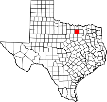 | |
| Towns | ||
| CDPs | ||
| Unincorporated communities | ||
| Ghost towns | ||
| Footnotes | ‡This populated place also has portions in an adjacent county or counties | |
Municipalities and communities of Tarrant County, Texas, United States | ||
|---|---|---|
| Cities |
|  |
| Towns | ||
| CDPs | ||
| Unincorporated communities | ||
| Historical communities | ||
| Ghost towns | ||
| Footnotes | ‡ This populated place also has portions in an adjacent county or counties ‡‡ Previously considered a census-designated place | |