Grand Prairie, Texas
| Grand Prairie, Texas | |
|---|---|
| City | |
| City of Grand Prairie | |
|
Watertower at Market Square | |
| Nickname(s): GP | |
 Location of Grand Prairie in Dallas and Tarrant County, Texas | |
 Grand Prairie, Texas Location in the contiguous United States | |
| Coordinates: 32°42′55″N 97°1′1″W / 32.71528°N 97.01694°WCoordinates: 32°42′55″N 97°1′1″W / 32.71528°N 97.01694°W | |
| Country |
|
| State |
|
| Counties | Dallas, Tarrant, Ellis |
| Government | |
| • Type | Council-Manager |
| • City Council |
Mayor Ron Jensen Richard Fregoe Jeff Wooldridge Greg Giessner Tony Shotwell Jim Swafford Jorja Clemson Lila Thorn |
| • City Manager | Tom Hart |
| Area | |
| • City | 81.091 sq mi (210.02 km2) |
| • Land | 72.105 sq mi (186.75 km2) |
| • Water | 8.986 sq mi (23.27 km2) |
| Elevation | 515 ft (157 m) |
| Population (2010)[1] | |
| • City | 175,396 |
| • Estimate (2013)[2] | 183,372 |
| • Rank | (US: 127th) |
| • Density | 2,433/sq mi (939/km2) |
| • Urban | 5,121,892 (6th) |
| • Metro | 6,810,913 (4th) |
| • Demonym | Grand Prairian |
| Time zone | CST (UTC-6) |
| • Summer (DST) | CDT (UTC-5) |
| ZIP codes | 75050-75054 |
| Area code(s) | 972, 214, 469, 817 |
| FIPS code | 48-30464[3] |
| GNIS feature ID | 1336802[4] |
| Website |
www |

Grand Prairie is a city in Dallas County, Tarrant County, and Ellis County, Texas, in the United States.[5] It is part of the Mid-Cities region in the Dallas–Fort Worth metroplex. Grand Prairie has a population of 175,396 according to the 2010 census, making it the fifteenth most populous city in the state.[6]
History
The city of Grand Prairie was first established as Dechman by Alexander McRae Dechman in 1863. Dechman, who was from Birdville, learned that he could trade his oxen and wagons for land in Dallas County. In 1863, Dechman bought 239.5 acres (96.9 ha) of land on the eastern side of the Trinity River and 100 acres (40 ha) of timber land on the west side of the river for a broken-down wagon, oxen team and US$200 in Confederate money. He tried to establish a home on the property, but ran into difficulties, so he returned to his family in Birdville before joining in the Civil War. In 1867 he filed a town plat consisting of 50 acres (20 ha) with Dallas County.
After the war, he returned to Birdville for two years before selling that farm in 1867 and moving to Houston, where yellow fever broke out, causing the family to settle in Bryan. In 1876, Dechman traded half his "prairie" property to the T&P Railroad to ensure the railroad came through the town. The railroad named the depot "Dechman", prompting its namesake to relocate his home from Bryan to Dechman. His son Alexander had been living in Dechman and operating a trading post and farm. The first church in the area was the Good Hope Cumberland Sabbath School, established in 1870 by Rev. Andrew Hayter. The church was later renamed West Fork United Presbyterian Church and remains an active church.[7]
The first U.S. post office opened in 1877 under the name "Deckman" rather than "Dechman", because the U.S. Postal Service couldn't read the writing on the form completed to open the post office. Later that same year, after the Postal Service had adopted the "Deckman" name, confusion resulted from the T&P Railroad designation "Grand Prairie". This name was based on maps drawn from around 1850 through 1858 that labeled the area between Dallas and Fort Worth "the grand prairie of Texas". In order to alleviate the confusion, the Postal Service named the post office "Grand Prairie".
The town of Grand Prairie was eventually incorporated as a city in 1909. During World War I and since, Grand Prairie has had a long history with the defense and aviation industry. While the present-day Vought plant on Jefferson Avenue is part of a small strip within the Dallas city limits, it was originally in Grand Prairie. During World War II the North American Aviation Plant B produced the Consolidated B-24 Liberator and the P-51C and K Mustang variants. After the war, Vought Aircraft took over the plant. This later became Ling Temco Vought (LTV) and then eventually returned to the Vought moniker. The plant was the production site for the F-8 Crusader and the A-7 Corsair II aircraft of the 1950-1989 time period. The LTV Missile and Space division produced missiles such as the Scout and MLRS. This division was eventually sold to Lockheed Martin, which continues to operate in Grand Prairie. Grand Prairie was also the North American headquarters for Aérospatiale Helicopter. This company eventually became Airbus Helicopters, Inc., the U.S. subsidiary of Airbus Helicopters.
In 1953, the mayor and city council of Grand Prairie went on a "land grab", and attempted to annex nearly 70 square miles (180 km2) of then-unincorporated and largely undeveloped land in southern Dallas and Tarrant counties. Vehement debate ensued, and the legal pressure from cities like Arlington, Duncanville and Irving wound up overturning the unprecedented annexation attempt.
Geography
Grand Prairie is located along the border between Tarrant and Dallas counties, with a small portion extending south into Ellis County. The city is bordered by Dallas to the east, Cedar Hill and Midlothian to the southeast, Mansfield to the southwest, Arlington to the west, Fort Worth to the northwest, and Irving to the north.
According to the United States Census Bureau, the city has a total area of 81.1 square miles (210.0 km2), of which 72.1 square miles (186.8 km2) is land and 9.0 square miles (23.3 km2), or 11.08%, is water.[8]
The West Fork of the Trinity River and a major tributary, Johnson Creek, flow through Grand Prairie.
Grand Prairie has a long history of flooding from Johnson Creek. In the 1980s, a major Army Corps of Engineers project was begun to straighten the channel, which has reduced the damage of flooding.
Surrounding municipalities
 |
Euless (12 miles) |
Irving (7 miles) |
Irving | |
| Arlington (6 miles) |
|
Dallas | ||
| ||||
| | ||||
| Mansfield (20 miles) |
Joe Pool Lake | Cedar Hill (12 miles) |
Demographics
| Historical population | |||
|---|---|---|---|
| Census | Pop. | %± | |
| 1910 | 994 | — | |
| 1920 | 1,263 | 27.1% | |
| 1930 | 1,529 | 21.1% | |
| 1940 | 1,595 | 4.3% | |
| 1950 | 14,594 | 815.0% | |
| 1960 | 30,386 | 108.2% | |
| 1970 | 50,904 | 67.5% | |
| 1980 | 71,462 | 40.4% | |
| 1990 | 99,616 | 39.4% | |
| 2000 | 127,427 | 27.9% | |
| 2010 | 175,396 | 37.6% | |
| Est. 2015 | 187,809 | [9] | 7.1% |
| U.S. Decennial Census[10] 2013 Estimate[11] | |||
As of 2010 Grand Prairie had a population of 175,396. The racial and ethnic composition of the population was 52.6% White, 20.0% Black, 0.8% Native American, 6.5% Asian, 0.1% Pacific Islander, 0.1% non-Hispanic of some other race, 3.2% of two or more races and 42.7% Hispanic or Latino.[12]
As of the census[3] of 2000, there were 127,427 people, 43,791 households, and 32,317 families residing in the city. The population density was 1,784.6 people per square mile (689.1/km²). There were 46,425 housing units at an average density of 650.2 per square mile (251.0/km²). The racial makeup of the city was 62% White, 13.5% African American, 0.8% Native American, 4.42% Asian, 0.1% Pacific Islander, 15.90% from other races, and 3.34% from two or more races. Hispanic or Latino of any race were 33% of the population.
There were 43,791 households out of which 41.3% had children under the age of 18 living with them, 54.9% were married couples living together, 13.7% had a female householder with no husband present, and 26.2% were non-families. 20.7% of all households were made up of individuals and 4.5% had someone living alone who was 65 years of age or older. The average household size was 2.90 and the average family size was 3.38.
In the city the population was spread out with 30.5% under the age of 18, 10.1% from 18 to 24, 34.1% from 25 to 44, 18.8% from 45 to 64, and 6.4% who were 65 years of age or older. The median age was 30 years. For every 100 females there were 98.0 males. For every 100 females age 18 and over, there were 95.2 males.
The median income for a household in the city was $46,816, and the median income for a family was $51,449. Males had a median income of $35,300 versus $28,184 for females. The per capita income for the city was $18,978. About 8.7% of families and 11.1% of the population were below the poverty line, including 15.2% of those under age 18 and 10.4% of those age 65 or over.
Climate
Grand Prairie is part of the humid subtropical region.
| Climate data for Grand Prairie 1981–2013 Normals | |||||||||||||
|---|---|---|---|---|---|---|---|---|---|---|---|---|---|
| Month | Jan | Feb | Mar | Apr | May | Jun | Jul | Aug | Sep | Oct | Nov | Dec | Year |
| Record high °F (°C) | 85 (29) |
90 (32) |
100 (38) |
100 (38) |
101 (38) |
112 (44) |
111 (44) |
109 (43) |
107 (42) |
101 (38) |
91 (33) |
87 (31) |
112 (44) |
| Average high °F (°C) | 56.6 (13.7) |
60.7 (15.9) |
68.0 (20) |
75.8 (24.3) |
83.4 (28.6) |
90.7 (32.6) |
95.5 (35.3) |
96.2 (35.7) |
88.5 (31.4) |
78.5 (25.8) |
67.6 (19.8) |
57.3 (14.1) |
76.6 (24.8) |
| Average low °F (°C) | 36.5 (2.5) |
40.5 (4.7) |
47.9 (8.8) |
55.5 (13.1) |
64.0 (17.8) |
72.0 (22.2) |
75.8 (24.3) |
75.9 (24.4) |
68.1 (20.1) |
57.7 (14.3) |
46.6 (8.1) |
37.5 (3.1) |
56.6 (13.7) |
| Record low °F (°C) | −2 (−19) |
9 (−13) |
12 (−11) |
30 (−1) |
39 (4) |
53 (12) |
58 (14) |
58 (14) |
42 (6) |
24 (−4) |
16 (−9) |
1 (−17) |
−2 (−19) |
| Average precipitation inches (mm) | 2.2 (56) |
2.6 (66) |
2.9 (74) |
3.3 (84) |
5.0 (127) |
4.7 (119) |
2.4 (61) |
2.0 (51) |
2.8 (71) |
4.5 (114) |
2.5 (64) |
2.4 (61) |
37.4 (950) |
| Average snowfall inches (cm) | 0.5 (1.3) |
0.2 (0.5) |
0.1 (0.3) |
0 (0) |
0 (0) |
0 (0) |
0 (0) |
0 (0) |
0 (0) |
0 (0) |
0 (0) |
0.3 (0.8) |
1.1 (2.8) |
| Average precipitation days (≥ 0.01 in) | 7.4 | 6.6 | 7.5 | 7.2 | 10.2 | 8.0 | 4.8 | 4.9 | 5.4 | 7.5 | 6.7 | 7.2 | 83.4 |
| Average snowy days (≥ 0.1 in) | 0.4 | 0.3 | 0.3 | 0 | 0 | 0 | 0 | 0 | 0 | 0 | 0 | 0.1 | 1.1 |
| Source: Weatherbase.com [13] | |||||||||||||
Government
Local government
According to the city's 2007-2008 Comprehensive Annual Financial Report, the city's various funds had $275.5 million in revenues, $236.4 million in expenditures, $1,003.2 million in total assets, $424.9 million in total liabilities, and $305.9 million in cash and investments.[14]
The structure of the management and coordination of city services is:[14]
| City Department | Director |
|---|---|
| City Manager | Tom Hart |
| Airport Director | Jon Seale |
| Court Services Director | Steven Cherry |
| Budget Director | Kathleen Mercer |
| Director of Planning and Development | Bill Crolley |
| Environmental Services Director | Jim Cummings |
| City Secretary | Cathy DiMaggio |
| Parks & Recreation Director | Rick Herold |
| Police Chief | Steve Dye |
| Housing & Neighborhood Services Director | Bill Hills |
| Public Works Director | Ron McCuller |
| Fire Chief | Robert Fite |
| Human Resources Director | Lisa Norris |
| Chief Financial Officer | Diana Ortiz |
| Economic Development & Information Technology Director | Bob O'Neal |
| City Attorney | Don Postell |
| Transportation Director | Jim Sparks |
| Marketing Director & Library Director | Amy Sprinkles |
| Management Services Director | Cathy Patrick |
The Parkland Health & Hospital System (Dallas County Hospital District) operates the E. Carlyle Smith, Jr. Health Center in Grand Prairie.[15]
Grand Prairie as of 2012 has 320 municipal police officers
The city of Grand Prairie is a voluntary member of the North Central Texas Council of Governments association, the purpose of which is to coordinate individual and collective local governments and facilitate regional solutions, eliminate unnecessary duplication, and enable joint decisions.
Federal representation
The Bureau of Prisons (BOP), of the U.S. Department of Justice runs the Grand Prairie Office Complex on the grounds of the U.S. Armed Forces Reserve Complex.[16] Within the complex the BOP operates the Designation and Sentence Computation Center (DSCC), which calculates federal sentences, keeps track of the statutory "good time" accumulated by inmates and lump sum extra "good time" awards, and detainers.[17] The BOP South Central Office is also on the armed forces complex grounds.[18]
Economy
According to the city's 2008 Comprehensive Annual Financial Report,[14] the top employers in the city are:
| # | Employer | # of Employees |
|---|---|---|
| 1 | Grand Prairie Independent School District | 3,200 |
| 2 | Lockheed Martin Missiles and Fire Control | 2,600 |
| 3 | Poly-America, Inc. | 2,000 |
| 4 | Bell Helicopter-Textron | 1,300 |
| 5 | Lone Star Park at Grand Prairie | 1,200 |
| 6 | City of Grand Prairie | 1,200 |
| 7 | Vought Aircraft Industries | 700 |
| 8 | Siemens Energy & Automation, Inc. | 600 |
| 9 | Hanson Pipe & Products | 500 |
| 10 | Wal-Mart | 500 |
Six Flags maintains a corporate office in Grand Prairie.[19] Airbus Helicopters, Inc., the U.S. subsidiary of Airbus Helicopters, has its headquarters in Grand Prairie.[20]
In 1978 American Airlines announced that it would move its headquarters from New York City to the Dallas/Fort Worth area.[21] The airline moved its headquarters into two leased office buildings in Grand Prairie. The airline finished moving into its Fort Worth headquarters facility on January 17, 1983, when the airline left its Grand Prairie facility.[21]
Education
Primary and secondary schools
Public schools
Most of Grand Prairie's K-12 student population attends schools in the Grand Prairie Independent School District, which serves areas of Grand Prairie in Dallas County. The Mansfield Independent School District serves areas of Grand Prairie in Tarrant County and operates six elementary schools within the Grand Prairie city limits. Other portions of Grand Prairie reside within the Arlington, Cedar Hill, Irving, Mansfield, and Midlothian school districts.[22]
In Texas, school district boundaries do not follow city and county boundaries because all aspects of the school district government apparatus, including school district boundaries, are separated from the city and county government entirely, with the exception of the Stafford Municipal School District in the Houston area.
Grand Prairie Independent School District
The high schools in the district are South Grand Prairie High School, Grand Prairie High School, Crosswinds High School and Dubiski Career High School. Middle schools include YMLA at Kennedy, Jackson, Reagan, Truman, Fannin, and Adams. Elementary schools include Austin, Bonham, Bowie, Bush, Crockett, Daniels, Dickinson, Eisenhower, Florence Hill, Garcia, Garner, Johnson, Lee, Marshall, Milam, Monroe, Moseley, Powell, Rayburn, Seguin, Travis, Whitt, Williams, and Zavala. However, YWLA at Bill Arnold offers both high school and middle school education.
Arlington Independent School District
The Arlington ISD has the second highest portion of Grand Prairie's K-12 student population. Six Arlington ISD elementary schools are within the city limits of Grand Prairie. Grand Prairie residents in the Arlington ISD are located generally west of the Dallas-Tarrant County boundary and north of the intersection of Camp Wisdom and Lake Ridge in southwest Grand Prairie. One of the Arlington high schools, James Bowie High, has more Grand Prairie residents than Arlington residents that are students at the school.
Grand Prairie student/residents in the Arlington ISD attend Bowie, Sam Houston, or Lamar High School in the Arlington ISD and their feeder elementary schools and junior high schools.
Mansfield Independent School District
The Mansfield ISD contains the third highest portion of the Grand Prairie's K-12 student population. Grand Prairie residents in the Mansfield ISD are located generally south of the intersection of Camp Wisdom and Lake Ridge, and west of Joe Pool Lake to the Tarrant and Ellis County line in southwest Grand Prairie. Three Mansfield ISD schools, Anna May Daulton Elementary; Louise Cabaniss Elementary; and Cora Spencer Elementary, are currently open within the city limits of Grand Prairie. The Mansfield ISD is the fastest growing ISD in Tarrant County, and the population growth in far southwest Grand Prairie is a major factor in the Mansfield ISD's subsequent growth.
Grand Prairie students/residents in the Mansfield ISD attend Mansfield Timberview High School or Mansfield High School in the Mansfield ISD or their feeder elemetaries and junior highs. Timberview High School is located on State Highway 360 less than 100 yards (91 m) from the Grand Prairie city line.
Infrastructure
Transportation


Interstate highways 20 and 30 run east-west through the northern and southern parts of the city. Texas State Highways Spur 303 (named Pioneer Parkway) and 180 (Main Street) also run east-west in the northern and central portions of the city.
SH 360 runs for almost three miles in the northwestern portion of city; most of the highway runs just west of the city limits in Arlington.
SH 161, named the President George Bush Turnpike, runs north-south through western Grand Prairie. The main lanes were opened in late 2012 with frontage roads open since 2010. Portions of the highway located north of SH 180 are depressed while the portion south of SH 180 runs at-grade then becomes elevated. Frontage roads remain at-grade throughout. The frontage road intersection at Main Street will open sometime in 2013.[23]
Belt Line Road is a major north-south thoroughfare in the city. The section of the road south of Main Street is dual-labelled as FM 1382, which travels south, past I-20 and continues south to Cedar Hill. The section of the road north of Main Street keeps its name, continuing north into Irving.
There is presently no public transportation in Grand Prairie, as the city is not a member of DART. The city declined membership in 1984.
Attractions
- In 1997 Lone Star Park was opened, where each Memorial Day the Thoroughbred Meeting is held, with seven stakes races worth just over $1 million.
- In 2000 GPX Skate Park was opened next to Lone Star Park, which hosted the 2001 and 2002 X Games trials. They closed in 2005 and were later re-opened in June 2006 by the Grand Prairie Parks and Recreation committee.
- The state-of-the-art Verizon Theatre at Grand Prairie, previously NextStage and Nokia Theater, is in Grand Prairie. Numerous concerts and other events are held here throughout the year.
- Prairie Lights[24] is a 2-mile-long (3.2 km) seasonal display, featuring more than three million lights on more than 500 lighted displays. Santa's elves, snowmen, reindeer, angels, penguins, stars, lollipops and the world's longest tunnel of lights are just a few of the displays showcased during the 40-day event. The theme park also offers a unique out-of-car experience in Holiday Village midway through the drive with concessions, carousel rides, Santa's Store for shopping and photos with Santa on Friday, Saturday and Sunday.
- In 1973, Traders Village[25] was opened off of Mayfield Road, & State Highway 360. It describes itself as the largest flea market in Texas, open on weekends from 7 A.M. until dusk. Special events are held at Traders Village on certain weekends, including a chili cookoff, auto swap-meet, etc.
- The Grand Prairie AirHogs minor league baseball team and their stadium, The Ballpark in Grand Prairie, were established in Grand Prairie in May 2007 and started play in May 2008.
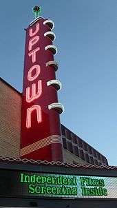
- The historic Uptown Theatre[26] in downtown Grand Prairie, re-opened in 2008 after a year of renovations. It is now a playhouse and venue for concerts.
- The National Recreation and Parks Association (NRPA) bestowed its highest national award, the Gold Medal Award, to the Grand Prairie, Texas Parks and Recreation Department at the 2008 NRPA's Congress and Exposition in Baltimore. Grand Prairie, Texas won the award in the population group of 100,000-250,000. Grand Prairie is once again a finalist for the award in 2016. Grand Prairie offers some of the best parks and recreation venues in the country.
- Located near I-30 and Beltline Rd, Turner Park became Grand Prairie's Heritage (1st ever) Park back in the 1940s and today it features one of the top Disc Golf courses in North Texas.
Notable people
- Larry D. Alexander, artist and writer[27]
- Rodney Anderson, Republican member of the Texas House of Representatives from Grand Prairie (2011-2013); born in Grand Prairie[28]
- Wesley Duke, professional football player[29]
- Selena Gomez, actress and singer[30]
- Nets Katz, 2012 Guggenheim Fellow and Professor of Mathematics at Caltech[31]
- Billy Miller, actor, Daytime Emmy winner (The Young and the Restless)
- Hayley Orrantia, actress and singer, raised in Grand Prairie
- Kenneth Sheets, Republican member of the Texas House of Representatives from District 107 in Dallas County; native of Grand Prairie and graduate of Grand Prairie High School[32]
- Charley Taylor, professional football player[33]
- Eric Vale, voice actor affiliated with Funimation
- Kerry Wood, Major League Baseball pitcher[34]
References
- ↑ "American FactFinder". United States Census Bureau. Retrieved September 10, 2014.
- ↑ "Population Estimates". United States Census Bureau. Retrieved March 19, 2015.
- 1 2 "American FactFinder". United States Census Bureau. Retrieved 2008-01-31.
- ↑ "US Board on Geographic Names". United States Geological Survey. 2007-10-25. Retrieved 2008-01-31.
- ↑ http://www.gptx.org/index.aspx?page=1134
- ↑ "Geographic Identifiers: 2010 Census Summary File 1 (G001): Grand Prairie city, Texas". American Factfinder. U.S. Census Bureau. Retrieved March 25, 2016.
- ↑ Texas State Historical Marker 5760
- ↑ "Geographic Identifiers: 2010 Demographic Profile Data (G001): Grand Prairie city, Texas". U.S. Census Bureau, American Factfinder. Retrieved November 30, 2011.
- ↑ "Annual Estimates of the Resident Population for Incorporated Places: April 1, 2010 to July 1, 2015". Retrieved July 2, 2016.
- ↑ United States Census Bureau. "Census of Population and Housing". Retrieved April 29, 2015.
- ↑ "Annual Estimates of the Resident Population: April 1, 2010 to July 1, 2013". Retrieved April 29, 2015.
- ↑ Grand Prairie (city), Texas, 2012 QuickFacts
- ↑ "Grand Prairie, Texas Travel Weather Averages (Weatherbase)". Weatherbase. Retrieved April 6, 2015.
- 1 2 3 City of Grand Prairie CAFR Retrieved 2009-07-16
- ↑ "Clinic Sites and Services:" Parkland Health & Hospital System. Retrieved on October 25, 2012.
- ↑ "Grand Prairie Office Complex." Federal Bureau of Prisons. Retrieved on January 9, 2010.
- ↑ Zych, C. "Admission and Orientation Handbook Federal Correctional Institution Milan, Michigan." Federal Bureau of Prisons. 6 (8 of 24). Retrieved on May 8, 2010.
- ↑ "RO South Central." Federal Bureau of Prisons. Retrieved on June 1, 2015. "US ARMED FORCES RESERVE CMPL GRAND PRAIRIE, TX 75051"
- ↑ "Contact Us." Six Flags. Retrieved on May 6, 2009.
- ↑ "Contact Us." American Eurocopter. Retrieved on December 8, 2010. "American Eurocopter 2701 N. Forum Drive Grand Prairie, TX 75052."
- 1 2 "American Airlines Finishes Moving into Headquarters Monday." Associated Press at Ocala Star-Banner. January 16, 1983. 6A. Google News 4 of 62. Retrieved on August 27, 2009.
- ↑ "Greetings from Grand Prairie." City of Grand Prairie. Retrieved on December 27, 2008.
- ↑ https://www.ntta.org/roadsprojects/projprog/pgbtwestext/Pages/default.aspx
- ↑ http://www.prairielights.org
- ↑ http://tradersvillage.com/grand-prairie/
- ↑ http://www.uptowntheatergp.com/
- ↑ "Legendary Locals of Grand Prairie". Retrieved August 12, 2016.
- ↑ "Rodney Anderson". Texas Legislative Reference Library. Retrieved March 11, 2014.
- ↑ "Wesley Duke". databaseFootball.com. Retrieved April 2, 2013.
- ↑ Lauren Waterman (2009-05).Selena Gomez: spell bound Teen Vogue. Retrieved May 11, 2009.
- ↑ "Reducing Coincidence with Mathematics: An Interview with Nets Katz". Caltech. Retrieved December 6, 2014.
- ↑ "State Rep. Kenneth Sheets District 107 (R-Dallas)". The Texas Tribune. Retrieved March 21, 2014.
- ↑ "Charley Taylor". databaseFootball.com. Retrieved April 2, 2013.
- ↑ "Kerry Wood Stats". Baseball Almanac. Retrieved April 2, 2013.
External links
| Wikimedia Commons has media related to Grand Prairie, Texas. |
Municipalities and communities of Dallas County, Texas, United States | ||
|---|---|---|
| Cities | 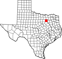 | |
| Towns | ||
| Unincorporated communities | ||
| Historical communities | ||
| Footnotes | ‡This populated place also has portions in an adjacent county or counties | |
Municipalities and communities of Ellis County, Texas, United States | ||
|---|---|---|
| Cities |  | |
| Towns | ||
| CDP | ||
| Unincorporated communities | ||
| Footnotes | ‡This populated place also has portions in an adjacent county or counties | |
Municipalities and communities of Tarrant County, Texas, United States | ||
|---|---|---|
| Cities |
|  |
| Towns | ||
| CDPs | ||
| Unincorporated communities | ||
| Historical communities | ||
| Ghost towns | ||
| Footnotes | ‡ This populated place also has portions in an adjacent county or counties ‡‡ Previously considered a census-designated place | |

| ||
| ||