West Singhbhum district
| West Singhbhum district पश्चिमी सिंहभूम जिला | |
|---|---|
| District of Jharkhand | |
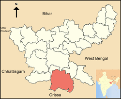 Location of West Singhbhum district in Jharkhand | |
| Country | India |
| State | Jharkhand |
| Administrative division | Kolhan division |
| Headquarters | Chaibasa |
| Government | |
| • Lok Sabha constituencies | Singhbhum (shared with Seraikela Kharsawan district) |
| • Assembly seats | 5 |
| Area | |
| • Total | 5,351 km2 (2,066 sq mi) |
| Population (2011) | |
| • Total | 1,501,619 |
| • Density | 280/km2 (730/sq mi) |
| Demographics | |
| • Literacy | 59.54 per cent |
| • Sex ratio | 1001 |
| Average annual precipitation | 1422 mm |
| Website | Official website |
West Singhbhum or Pashchimi Singhbhum(hindi:पश्चिमी सिंहभूम जिला) (Singhbhum) (Ho:𑢹𑣞𑣃𑣜 𑢾𑣂𑣍𑣙𑣞𑣁),(Bengali:পশ্চিম সিংভুম জেলা ) is one of the 24 districts of Jharkhand state, India. It came into being in 1990, when the old Singhbhum district was bifurcated. Chaibasa is the district headquarters.
The district is bounded on north by Khunti district, on the east by Saraikela Kharsawan district, on the south by Keonjhar, Mayurbhanj and Sundergarh districts of Odisha and on the west by Simdega district of Jharkhand and Sundergarh district of Odisha.
History
West Singhbhum (Ho:𑢹𑣞𑣃𑣜 𑢾𑣂𑣍𑣙𑣞𑣁) (bengal:পশ্চিম সিংভূম) is one of the oldest districts of Jharkhand .The word Singhbhumis derived from bengali words 'singha'(সিংহ) meaning "lion" and 'bhumi'(ভূমি) meaning "land" ,together meaning "The Land Of Lions". After the British conquest of Kolhan in 1837, a new district was consequently constituted to be known as Singhbhum with Chaibasa as its headquarters. Subsequently three districts, namely East Singhbhum, West Singhbhum and Saraikela-Kharsawan have been carved out of erstwhile Singhbhum district.
West Singhbhum district came into existence when the old Singhbhum District bifurcated in 1990. With 9 community development blocks the Eastern part became East Singhbhum district with Jamshedpur as its headquarters and with remaining 23 blocks the larger Western part became West Singhbhum district with Chaibasa as its headquarters. In 2001 West Singhbhum again divided into two parts. With 8 blocks Saraikela-Kharsawan district came into existence. At present West Singhbhum remains with 15 blocks and two administrative sub-divisions.
There are several accounts relating to the origin of the name of the district:
- According to one the name Singhbhum, or the land of "Singhs" has been derived from the patronymic of the Singh Rajas of Porahat, the junior branch of whom went on to found the ruling "Singh Deo" family of Saraikela State.
- A second account suggests that the name is a corrupt form of the Singh Bonga (𑢾𑣂𑣍𑣗𑣉𑣊𑣋𑣁) the principal deity of the district's tribal population.
- Yet another origin of the name could be the literal meaning land of lions (in Bengali) from words Singh for lion and Bhumi for land, referring directly to the animals.
It is currently a part of the Red Corridor.[1]
Geography
West Singhbhum district forms the Southern part of the newly created Jharkhand state and is the largest district in the state. The district spreads from 21.97°N to 23.60°N and from 85.00°E to 86.90°E. The district is situated at an average height of 244 metres above sea level and covers an area of 5351.41 km².
The district is covered with hills alternating with valleys, steep mountains, and deep forests on the mountain slopes. It contains some of the best Sal tree forests and the famous Saranda forest. There are plenty of waterfalls and a large variety of wild life like elephants, bisons, tigers, leopards, bear, wild dogs and wild boars. Sambar Deer, deer and spotted deer are also found but their numbers are decreasing in the forests adjoining inhabited areas.
The district contains large deposits of iron ore which are increasingly being mined to feed the growing demand for steel production.
Rivers
Following are some of the rivers flowing in the West Singhbhum District: Koel, Karo-Koina,kuju, Kharkai, Sanjai, Roro, Deo, and Baitarini.[2]
Mines and minerals
The greater part of West Singhbhum district is covered with deposits of iron-ore and other industrially important minerals including the following:
- Chromite
- Magnetite
- Manganese
- Kainite
- Lime Stone
- Iron Ore
- Asbestos
- Soap-stone
Administration
Blocks/Mandals
West Singhbhum district consists of 19 Blocks. The following are the list of the Blocks in West Singhbhum district:
- Chaibasa
- Khuntipani
- Jhinkpani
- Tonto
- Kumardungi
- Tantnagar
- Jagannathpur
- Manjhari
- Manjhgaon
- Noamundi
- Chakradharpur
- Bandgaon
- Manoharpur
- Goilkera
- Sonua
- Gudri
- Anandpur
- Hatgamharia
Demographics
According to the 2011 census West Singhbhum district has a population of 1,501,619,[3] roughly equal to the nation of Gabon[4] or the US state of Hawaii.[5] This gives it a ranking of 335th in India (out of a total of 640).[3] The district has a population density of 209 inhabitants per square kilometre (540/sq mi) .[3] Its population growth rate over the decade 2001-2011 was 21.69%.[3] Pashchimi Singhbhum has a sex ratio of 1004 females for every 1000 males,[3] and a literacy rate of 59.54%.[3]
The majority of the population of West Singhbhum consists of Hos.
Flora and fauna
West Singhbhum district is full of dense forests and hills and harbors a variety of flora and fauna.
References
- ↑ "83 districts under the Security Related Expenditure Scheme". IntelliBriefs. 2009-12-11. Retrieved 2011-09-17.
- ↑ "West Singhbhum district of Jharkhand". River Systempublisher = District administration. Retrieved 2010-04-20.
- 1 2 3 4 5 6 "District Census 2011". Census2011.co.in. 2011. Retrieved 2011-09-30.
- ↑ US Directorate of Intelligence. "Country Comparison:Population". Retrieved 2011-10-01.
Gabon 1,576,665
- ↑ "2010 Resident Population Data". U. S. Census Bureau. Retrieved 2011-09-30.
Hawaii 1,360,301
External links
- West Singhbhum District Administration website
- List of places in West-Singhbhum
 |
Khunti district | Seraikela Kharsawan district | | |
| Simdega district | |
|||
| ||||
| | ||||
| Sundargarh district, Odisha | Kendujhar district, Odisha | Mayurbhanj district, Odisha |
Coordinates: 22°34′00″N 85°49′00″E / 22.5667°N 85.8167°E