Dumka district
| Dumka district दुमका जिला | |
|---|---|
| District of Jharkhand | |
 Location of Dumka district in Jharkhand | |
| Country | India |
| State | Jharkhand |
| Administrative division | Santhal Pargana Division |
| Headquarters | Dumka |
| Government | |
| • Lok Sabha constituencies | Dumka |
| • Assembly seats | 4 |
| Area | |
| • Total | 3,716 km2 (1,435 sq mi) |
| Population (2011) | |
| • Total | 1,321,096 |
| • Density | 360/km2 (920/sq mi) |
| Demographics | |
| • Literacy | 62.54 per cent |
| • Sex ratio | 974 |
| Website | Official website |
Dumka district (Hindi: दुमका जिला) is one of the twenty-four districts of Jharkhand state in eastern India, and Dumka is the administrative headquarters of this district. This district covers an area of 3716.02 km². This district has a population of 1,321,096 (2011 Census).
Economy
In 2006, the Indian government named Dumka one of the country's 250 most backward districts (out of a total of 640).[1] It is one of the 21 districts in Jharkhand currently receiving funds from the Backward Regions Grant Fund Programme (BRGF).[1]
Administration
Blocks/Mandals
Dumka district consists of 10 Blocks. The following are the list of the Blocks in Dumkadistrict:
Divisions
There are four Vidhan Sabha constituencies in this district: Sikaripara, Dumka, Jama and Jarmundi. All of these are part of Dumka Lok Sabha constituency.
Demographics
According to the 2011 census Dumka district has a population of 1,321,096,[2] roughly equal to the nation of Mauritius[3] or the US state of New Hampshire.[4] This gives it a ranking of 370th in India (out of a total of 640).[2] The district has a population density of 300 inhabitants per square kilometre (780/sq mi) .[2] Its population growth rate over the decade 2001-2011 was 19.39%.[2] Dumka has a sex ratio of 974 females for every 1000 males,[2] and a literacy rate of 62.54%.[2]
Education
On 10 January 1992 Siddhu Kanhu University was founded in Dumka, which, later, on 6 May 2003 renamed as Sido Kanhu Murmu University. This university has 13 constituent colleges, which include Santal Pargana College (founded in 1955) and S.P. Mahila College (founded in 1974).
Transport
| Jasidih–Dumka–Rampurhat | |||||||||||||||||||||||||||||||||||||||||||||||||||||||||||||||||||||||||||||||||||||||||||||||||||||||||||||||||||||||||||||||||||||||||||||||||||||||||||||||||||||||||||||||||||||||||||||||||||||||||||||||||||||||||||||||||||||||||||||||||||||||||||||||||||||||||||||||||||||||||||||||||||||||||||||||||||||||||||||||||||||||||||||||||||||||||||||||||||||||||||||||||||||||||||||||||||||||||||||||||||||||
|---|---|---|---|---|---|---|---|---|---|---|---|---|---|---|---|---|---|---|---|---|---|---|---|---|---|---|---|---|---|---|---|---|---|---|---|---|---|---|---|---|---|---|---|---|---|---|---|---|---|---|---|---|---|---|---|---|---|---|---|---|---|---|---|---|---|---|---|---|---|---|---|---|---|---|---|---|---|---|---|---|---|---|---|---|---|---|---|---|---|---|---|---|---|---|---|---|---|---|---|---|---|---|---|---|---|---|---|---|---|---|---|---|---|---|---|---|---|---|---|---|---|---|---|---|---|---|---|---|---|---|---|---|---|---|---|---|---|---|---|---|---|---|---|---|---|---|---|---|---|---|---|---|---|---|---|---|---|---|---|---|---|---|---|---|---|---|---|---|---|---|---|---|---|---|---|---|---|---|---|---|---|---|---|---|---|---|---|---|---|---|---|---|---|---|---|---|---|---|---|---|---|---|---|---|---|---|---|---|---|---|---|---|---|---|---|---|---|---|---|---|---|---|---|---|---|---|---|---|---|---|---|---|---|---|---|---|---|---|---|---|---|---|---|---|---|---|---|---|---|---|---|---|---|---|---|---|---|---|---|---|---|---|---|---|---|---|---|---|---|---|---|---|---|---|---|---|---|---|---|---|---|---|---|---|---|---|---|---|---|---|---|---|---|---|---|---|---|---|---|---|---|---|---|---|---|---|---|---|---|---|---|---|---|---|---|---|---|---|---|---|---|---|---|---|---|---|---|---|---|---|---|---|---|---|---|---|---|---|---|---|---|---|---|---|---|---|---|---|---|---|---|---|---|---|---|---|---|---|---|---|---|---|---|---|---|---|---|---|---|---|---|---|---|---|---|---|---|---|---|---|---|---|---|---|---|---|---|---|---|---|---|---|---|---|---|---|---|---|---|---|---|---|---|---|---|---|---|
| |||||||||||||||||||||||||||||||||||||||||||||||||||||||||||||||||||||||||||||||||||||||||||||||||||||||||||||||||||||||||||||||||||||||||||||||||||||||||||||||||||||||||||||||||||||||||||||||||||||||||||||||||||||||||||||||||||||||||||||||||||||||||||||||||||||||||||||||||||||||||||||||||||||||||||||||||||||||||||||||||||||||||||||||||||||||||||||||||||||||||||||||||||||||||||||||||||||||||||||||||||||||
Legend | |||||||||||||||||||||||||||||||||||||||||||||||||||||||||||||||||||||||||||||||||||||||||||||||||||||||||||||||||||||||||||||||||||||||||||||||||||||||||||||||||||||||||||||||||||||||||||||||||||||||||||||||||||||||||||||||||||||||||||||||||||||||||||||||||||||||||||||||||||||||||||||||||||||||||||||||||||||||||||||||||||||||||||||||||||||||||||||||||||||||||||||||||||||||||||||||||||||||||||||||||||||||
| |||||||||||||||||||||||||||||||||||||||||||||||||||||||||||||||||||||||||||||||||||||||||||||||||||||||||||||||||||||||||||||||||||||||||||||||||||||||||||||||||||||||||||||||||||||||||||||||||||||||||||||||||||||||||||||||||||||||||||||||||||||||||||||||||||||||||||||||||||||||||||||||||||||||||||||||||||||||||||||||||||||||||||||||||||||||||||||||||||||||||||||||||||||||||||||||||||||||||||||||||||||||
Dumka is a small town, it is connected with road to the neighboring city. However, in July 2011 Dumka is connected with newly built Jasidih - Dumka railway line. Since then city has seen a growing number of three Wheeler on road. Although there is an ongoing work on new railway line, which is connect Dumka to Bhagalpur (Bihar) and Rampurhat (west Bangal) in coming years.
But Buses are the preferred mode of transport and are run by both government agencies and private operators.Dumka has good connectivity to it neighboring district with buses.There is luxury night bus service between Dumka - Ranchi and Kolkata.
Tourist places
Baba Basukinath Dham
Basukinath is located in Dumka District of Jharkhand. It lies on the Deoghar – Dumka state highway and is around 25 km northwest of Dumka. It is a place of pilgrimage for Hindus. Basukinath Temple is the main attraction here.It is situated on Jasidih Dumka New Railway line and Basukinath Railway Station is the nearest railheads. Ranchi Airport is the nearest airport. It is situated at Jarmundi Block on Dumka Deoghar State Highway, 24 km from the District Headquarters Dumka. In a year lacs and lacs people from different parts of country come here to worship Lord Shiva. In the month of Shravan people of several country also come here to worship Lord Shiva. For more details, kindly follow : http://www.bababasukinath.com
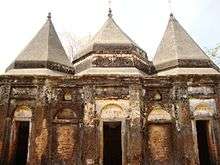
Maluti
Maluti is a historical and religious place where 78 extant Maluti temples are situated in clusters. It is in Shikaripara Block on Dumka - Rampurhat interstate highway, 55 km from Dumka District Headquarters. In 1860, Maluti was made tax-free capital by the then King Basant Rai alias Basant. This Maluti is associated with the archaeological and religious important place for natural beauty.


Baba Sumeshwar Nath
It is a religious place which is situated in Saraiyahat Block at the distance of 60 km from district headquarters Dumka. There is a big temple of the Lord Shiva. On the eve of Mahashivaratri the people of different parts of the district come here to worship Lord Shiva in addition to daily worshiping.
Masanjore Dam
Masanjore is a famous picnic spot situated in Dumka District of Jharkhand. This small village is about 31 km south of Dumka. The picturesque Masanjore dam on the Mayurakshi River is a major draw. From the counterpart rupee fund created through supplies of wheat and other materials from Canada for use in India, Canada Govt. devoted those funds to further development of the Mayurakshi project And Masanjore dam was commissioned in 1955. That's why the Dam still mentioned as Canada Dam. The dam is bounded by hills and forests, a perfect place for outing. Mayurakshi Bhawan Bungalow and Inspection Bungalow offer excellent and comfortable accommodation in the village. By road, Masanjore is connected with Vakreshwara (59 km), Sainthia (50 km), Tarapith (70 km), Rampurhat (62 km) and Deoghar (98 km). Masanjor dam or the Pearson dam on river Mayurakshi is a picturesque place on foot hills of long range of forest clad parallel hill ranges. This place is basically a hydro electric power generating center but in the process of time it has become popular center for the tourist. With the beautiful garden on the down hill and two beautiful dak-bungalows on the bank of the river at charm to its beauty.
Tatloi
It is a hot water spring, 15 km from the district headquarters of Dumka. It is rounded by small mounts, beautiful, attractive and greenish natural atmosphere. The water of spring is very clear and healthy.
Kumrabad
This is a very beautiful picnic spot. Just 13 km from the Dumka town, you find a rare view of natural beauty with small hills,beside that smooth flowing Mayurakshi River.
Hill Range
Running south from pakur to godda. The hill range of Dumka seen parallel and terminate in th Mangalbhanga hill. To the south east of Dumka is Ramgarh hills further west two parallel renges of hills also stretch in an easterly direction from Masanjor to Ranibhal. Beside hill ranges some hillocks are also in like (i) Lagwa hil at Nonihat under which lies the Tatloi hot water stream (ii) Hijla hill top. (iii) Sapchala hill top. (iv) Chuto pahadi. Maluti (Temple village on way to Rampurhat).
Kurwa (Shrishti)
It is a small picnic spot about 5 km to the south of Dumka. It has a beautiful park, facilities for boating and a small hill. Now boating facility is not available.
Chutonath
It is situated 20 km from the District headquarters. It is a beautiful place and picnic spot having natural beauty surrounded by hillocks and river. Chutonath is a religious place of Hindu god Lord chutonath.
Missionaries
New Life Foundation [http://nlfindia.org [5] is the first Christian Mission in the Katikund Block and runs one of its largest Child Rehabilitation Center 20 km from Dumka. Since its inception in 2005 New Life Children Home has been accorded to rehabilitate over 300 tribal children belonging to the various tribes of Jharkhand, Presently they house 98 children at their home. This organization has been certified with the ISO 9001:2008 recognition. They also run a school New Life Academy in the block that provides free primary education.
Diocese of Dumka
In a land area of 14,356 square kilometers, the diocesan territory covers Sahibganj, Pakur, Jamtara and Deoghar (excluding Deoghar, Mohanpur and Sarawan blocks) and Rampurhat sub-divion in Birbhum District in West Bengal.
Presently headed by Bishop Julius Marandi [6]
See also
References
- 1 2 Ministry of Panchayati Raj (September 8, 2009). "A Note on the Backward Regions Grant Fund Programme" (PDF). National Institute of Rural Development. Retrieved September 27, 2011.
- 1 2 3 4 5 6 "District Census 2011". Census2011.co.in. 2011. Retrieved 2011-09-30.
- ↑ US Directorate of Intelligence. "Country Comparison:Population". Retrieved 2011-10-01.
Mauritius 1,303,717 July 2011 est.
- ↑ "2010 Resident Population Data". U. S. Census Bureau. Retrieved 2011-09-30.
New Hampshire 1,316,470
- ↑ New Life Children Home
- ↑ [Dumka Diocese] http://directory.ucanews.com/dioceses/india-dumka/66
 |
Banka district, Bihar | Godda district | | |
| Deoghar district | |
Pakur district | ||
| ||||
| | ||||
| Jamtara district | Birbhum district, West Bengal |
Coordinates: 24°16′00″N 87°15′00″E / 24.2667°N 87.25°E