Jamshedpur
| Jamshedpur Tatanagar | ||||||||
|---|---|---|---|---|---|---|---|---|
| Metropolis | ||||||||
Clockwise from top: Sakchi Golchakkar, TCE Building, Sonari-Kadma Link Road, Tata Steel Plant, Bat Island in Jayanti Sarovar, JRD Tata Sports Complex | ||||||||
| Nickname(s): Steel City | ||||||||
 Jamshedpur Location of Jamshedpur in Jharkhand | ||||||||
| Coordinates: 22°47′N 86°12′E / 22.783°N 86.200°ECoordinates: 22°47′N 86°12′E / 22.783°N 86.200°E | ||||||||
| Country | India | |||||||
| State | Jharkhand | |||||||
| District | East Singhbhum | |||||||
| Founded by | Jamsetji Nusserwanji Tata | |||||||
| Named for | Iron and Steel, Cement Industries | |||||||
| Area[1] | ||||||||
| • Metropolis | 209 km2 (81 sq mi) | |||||||
| Elevation | 159 m (522 ft) | |||||||
| Population (2011)[2] | ||||||||
| • Metropolis | 1,337,131 | |||||||
| • Density | 6,400/km2 (17,000/sq mi) | |||||||
| • Metro | 631,364 | |||||||
| Time zone | IST (UTC+5:30) | |||||||
| PIN | 831001 to 831xxx | |||||||
| Telephone code | 0657 | |||||||
| Vehicle registration |
JH 05 (East Singhbhum) JH 22 (Saraikela-Kharsawan) BR 16 (Discontinued) | |||||||
| Literacy | 85.94% | |||||||
| Official language[3] | Hindi | |||||||
| Second languages | Bengali, Oriya, Santhali, Ho, Kurukh, Mundari, Kharia, Nagpuri, Panchpargania, Khortha and Kurmali.[4] | |||||||
| Website |
www | |||||||


Jamshedpur (/ˈdʒɑːmʃɛdpɔər/, ![]() pronunciation ) is the most populous urban agglomeration in the Indian state of Jharkhand.
pronunciation ) is the most populous urban agglomeration in the Indian state of Jharkhand.
Jamshedpur is the headquarters of the East Singhbhum district of Jharkhand. According to the 2011 census of India, Jamshedpur (East Singhbhum & Seraikela-Kharsawan) district has current population of 1,337,131; the Jamshedpur urban agglomeration (UA), which includes the adjoining areas, Jamshedpur Urban Area is the third Largest city in Eastern India. It is also the first planned industrial city of India. It is located on the Chota Nagpur plateau and is surrounded by the picturesque Dalma Hills. The city is bordered by the rivers Subarnarekha and Kharkai on the north and west parts of the city. Jamshedpur is home to world's tenth largest steel manufacturing company, Tata Steel.[5]
Jamshedpur has been predicted as the 84th fastest growing city in the world for the timeframe 2006–2020 with average annual growth of 2.59%.[6]
Etymology
In 1919 Lord Chelmsford named the city, which was earlier a village called Sakchi, to Jamshedpur in honour of its founder, Jamsetji Tata, whose birthday is celebrated on 3 March as Founder's Day. J. N. Tata had written to his son Dorabji Tata about his vision of a great city in the area. On Founders Day, the 225-acre (0.91 km2) Jubilee Park is decorated with brilliant lightwork for about a week.
The city has several nicknames, including "Industrial capital of Jharkhand" (spontaneous among native youngsters); "Steel City" (which was referenced during Tata Steel's "Green City—Clean City—Steel City" campaign); "Tatanagar" after the name of its railway station or simply "Tata" in deference to the presence of Tata companies. At one time it was also known as "Kalimati" (meaning "Land of Goddess Kali") after the village near the Sakchi area. Sakchi was renamed to Jamshedpur in 1919.[7] The only trace of the name is the main road through Sakchi area of Jamshedpur which is named Kalimati Road.
History
At the end of 19th century, Jamsetji Tata met steelmakers in Pittsburgh to get the most advanced technology for his plant. It is said that he got the idea of building a steel plant when he heard Thomas Carlyle declaring that "the nation which gains control of iron soon acquires the control of gold" in a lecture in Manchester.[8] At the turn of the twentieth century, Jamshetji Tata asked geologist Charles Page Perin to help him find the site to build India's first steel plant. The search for a site rich in iron, coal, limestone and water began in April 1904 in today's Madhya Pradesh.
The prospectors C. M. Weld, Dorabji Tata and Shapurji Saklatvala took nearly three years in a painstaking search across vast stretches of inhospitable terrain to find a location. One day they came across a village called Sakchi, on the densely forested stretches of the Chota Nagpur plateau, near the confluence of the Subarnarekha and Kharkai rivers. It seemed to be the ideal choice and the place was selected.[9]
In 1908 the construction of the plant as well as the city officially began.[9] The first steel ingot was rolled on 16 February 1912. It was a momentous day in the history of industrial India.[10]
Jamsetji's plan for the city was clear. He envisioned far more than a mere row of workers hutments. He insisted upon building all the comforts and conveniences a city could provide. As a result, many areas in the city are well planned and there are public leisure places such as the Jubilee Park. While building the city, Jamsetji Tata had said, "Be sure to lay wide streets planted with shady trees, every other of a quick growing variety. Be sure that there is plenty of space for lawns and gardens; reserve large areas for football, hockey and parks; earmark areas for Hindu temples, Muslim mosques and Christian churches."
Messrs Julin Kennedy Sahlin from Pittsburgh prepared the first layout of the town of Jamshedpur.[11] What the city looks like today is a testament to their visionary plans.[12] Jamshedpur is the only million plus city in India without a municipal corporation.
Legend has it that in the late 1980s when the state government proposed a law to end the Tatas' administration of Jamshedpur and bring the city under a municipality, the local populace rose in protest and defeated the government's proposal. In 2005, a similar proposal was once again put up by lobbying politicians. The target audience was the working class. A large majority sided with the government and set up protest meetings outside the East-Singhbhum Deputy Commissioner's office. However, the objective was never achieved and Jamshedpur remains without a municipality.[13][14][15]
Geography
Jamshedpur is situated in the southern end of the state of Jharkhand and is bordered by the states of Orissa and West Bengal. The average elevation of the city is 135 metres[16] while the range is from 129 m to 151 m.[17] Total geographical area of Jamshedpur is 150 km square.[18] Jamshedpur is primarily located in a hilly region and is surrounded by the Dalma Hills running from west to east and covered with dense forests. The other smaller hill ranges near the city are Ukam Hill and the Jadugoda-musabani hill range.[19] The city is also a part of the larger Chota Nagpur Plateau region. The region is formed of the sedimentary, metamorphic and igneous rocks belonging to the Dharwarian period.
Jamshedpur is located at the confluence of Kharkai and Subarnarekha Rivers. Subarnarekha is the principal river of Jamshedpur, which flows from west to south-eastern part of the territory. Many small rivers, especially the tributaries, join the Subarnarekha river in this area. Kharkai flows from the south and joins the Subarnarekha river at a place called Domuhani. The two rivers are the major sources of drinking water and groundwater for the city. Several lakes of varying size are also located near the fringes of the city. The major of them being the Dimna lake located in between the Dalma range and the Sitarampur reservoir situated beside Kharkai river. It's also a major tourist spot in the region.[20] Both of them also act as reservoirs for drinking water in the city.
The city falls under deciduous type of forest region and the green cover is estimated to be around 33% of the total land area.[21] The city falls under the Seismic Zone II region.[22]
Climate
Jamshedpur features a tropical wet and dry climate (Köppen: Aw). Summers start in mid-March and can be extremely hot in May and June. The temperature variation during summer is from 35 to 49 °C (95 to 120 °F). The minimum temperature during winters is 1 °C (34 °F). The climate of Jamshedpur is marked by south-west monsoon. Jamshedpur gets heavy rainfall from July to September and receives about 1,200 mm (47 in) of rainfall annually.
| Climate data for Jamshedpur, India (1971–2000) | |||||||||||||
|---|---|---|---|---|---|---|---|---|---|---|---|---|---|
| Month | Jan | Feb | Mar | Apr | May | Jun | Jul | Aug | Sep | Oct | Nov | Dec | Year |
| Record high °C (°F) | 34.6 (94.3) |
38.6 (101.5) |
42.5 (108.5) |
46.3 (115.3) |
46.5 (115.7) |
46.6 (115.9) |
39.7 (103.5) |
38.6 (101.5) |
36.0 (96.8) |
35.8 (96.4) |
34.8 (94.6) |
32.5 (90.5) |
46.6 (115.9) |
| Average high °C (°F) | 26.2 (79.2) |
29.0 (84.2) |
34.2 (93.6) |
38.6 (101.5) |
38.8 (101.8) |
35.9 (96.6) |
32.3 (90.1) |
31.8 (89.2) |
32.1 (89.8) |
31.6 (88.9) |
29.1 (84.4) |
26.2 (79.2) |
32.2 (90) |
| Average low °C (°F) | 11.5 (52.7) |
14.2 (57.6) |
18.4 (65.1) |
23.4 (74.1) |
25.5 (77.9) |
25.7 (78.3) |
25.3 (77.5) |
25.1 (77.2) |
24.6 (76.3) |
21.7 (71.1) |
16.5 (61.7) |
11.6 (52.9) |
20.4 (68.7) |
| Record low °C (°F) | 4.4 (39.9) |
6.0 (42.8) |
10.0 (50) |
16.2 (61.2) |
17.7 (63.9) |
16.4 (61.5) |
20.7 (69.3) |
18.4 (65.1) |
18.9 (66) |
11.2 (52.2) |
6.6 (43.9) |
4.5 (40.1) |
4.4 (39.9) |
| Average precipitation mm (inches) | 14.7 (0.579) |
26.8 (1.055) |
33.0 (1.299) |
36.2 (1.425) |
79.5 (3.13) |
267.7 (10.539) |
331.1 (13.035) |
354.7 (13.965) |
260.5 (10.256) |
80.5 (3.169) |
10.1 (0.398) |
13.5 (0.531) |
1,508.5 (59.39) |
| Average rainy days | 1.6 | 1.9 | 2.5 | 3.3 | 5.8 | 11.7 | 16.1 | 16.3 | 11.8 | 4.4 | 1.0 | 1.0 | 77.5 |
| Source: India Meteorological Department (record high and low up to 2010)[23][24] | |||||||||||||
Demographics


According to the 2011 census of India,[25] the city of Jamshedpur had a population of 7,25,623, but the Jamshedpur Urban Agglomeration had a population of 13,37,131. The city is designated as a Million Plus Urban Agglomeration as per Government terminology.[26] Males constitute 52.1% of the population and females 47.9%. Tribals constitute around 28% of the population. Jamshedpur has an average literacy rate of 85.94% - higher than the national average of 74%. In Jamshedpur, 11.5% of the population is under six years of age.[27]
Economy
Jamshedpur is home to the first private iron and steel company of India. The areas surrounding Jamshedpur are rich in minerals, including iron ore, coal, manganese bauxite and lime. It is a modern, industrial city; the main industries being iron and steel, truck manufacturing, tinplate production, cement and other small and medium scale industries revolving around these products.

The largest factory is that of Tata Steel (the erstwhile Tata Iron and Steel Company or TISCO), situated almost at the centre of the city. Tata Steel is the largest iron and steel producing plant in India, as well as the oldest.[28]
Tata Steel has won the Prime Minister's Trophy for Best Integrated Steel Plant for a record six times,[29] and the Deming Prize for major advances in quality improvement.
The other major factory in the city is Tata Motors with Tata Hitachi Construction Machinery Co. Ltd, which manufactures heavy vehicles and construction/earth moving equipment. Tata Motors was previously called The Tata Engineering and Locomotive Company (TELCO), as railway locomotives were once manufactured here. The plant spreads over 822 acres, is one of the largest in the country, and at peak rate can roll out 450 vehicles per day.[30]
Civic administration
The civic administration of the city is under Urban Development Department, Govt of Jharkhand.
The major Urban Local Bodies are :
- Jamshedpur Notified Area Committee (JNAC)
- Mango Notified Area Committee (MMC)
- Tata Steel Industrial Township
- Jugsalai Nagar Palika (Jugsalai Municipality)
- Adityapur Nagar Nigam (AMC)
The government is considering creating a unified municipal administrative body called the Jamshedpur Urban Agglomeration or JUA. The proposed body would comprise the areas currently under the Jamshedpur Notified Area Committee, Mango Notified Area Committee, Adityapur Municipal corporation, Jugsalai Nagar Parishad
Transportation
Railways

Tatanagar Junction is a railway junction and a A-1 category model station on the Chakradharpur division, of the South Eastern Railway. Other railway stations in the city is Adityapur, Gamharia, Kandra, Govindpur etc.
Roadways

Jamshedpur is connected to other parts of India through national and state highways. The major highways are:
- National Highway 33 (NH33) touches the city and connects it to Mumbai and further joins the NH32, which connects with Kolkata, Delhi NH2, NH33 and NH6 connects it to Kharagpur, Kolkata.
- National Highway 32 (NH 32) connects Jamshedpur to Dhanbad, Via Bokaro.
- 4 lane Expressway (Adityapur-Kandra Road) connects Jamshedpur to Kandra via Gamahria.
- Marine Drive 4 lane Expressway connects Adityapur Toll Bridge to Mango via Kadma, Sonari through the western corridors of Jamshedpur
Airport
Sonari Airport is a tiny airport serving the city at present. It is spread over a 25-acre area in the Sonari area of the city. The airport is primarily used for bringing in chartered planes of TATA group.
Tata Steel had in proposed to set up a 600-acre (2.4 km2) Greenfield airport on the outskirts of Jamshedpur in Adityapur-Seraikela region. In June 2011 Tata Steel and TRIL entered formally into a joint venture for building the airport.[31] The new airport will be of international standard with a 10,000 ft runway, it will have the capacity to allow commercial airliners such as the Airbus A320 to land and take off which was not possible from the present airport.[32] As of Dec 2012, Land acquisition process has started for the Airport. Out of 528 acres of required land 90% is owned by Govt. whereas rest is private land. The company is at present facing opposition in the acquisition process from the local villagers.[33]
Education and research
XLRI, in Jamshedpur, is ranked among the best B-schools in India, founded in 1949; Mahatma Gandhi Memorial Medical College, established in 1961; and the engineering college National Institute of Technology, Jamshedpur, an Institute of National Importance.[34][35]
The National Metallurgical Laboratory (NML), one of the 38 Council of Scientific and Industrial Research (CSIR) laboratories, was inaugurated on 26 November 1950 by Jawaharlal Nehru.[36]
Shavak Nanavati Technical Institute (SNTI), established in 1921 as the technical training department of Tata Steel, now develops skilled employees for other companies as well. Its 400,000 volume library is one of the most popular in the city.[37][38]
Sports
Jamshedpur has a reputation as the sports capital of Jharkhand with Tata Steel promoting sporting activities. Jamshedpur's private clubs provide opportunities for activities, such as golf, tennis, squash, billiards, horse riding and water scootering.

and Keenan Stadium
Academies and stadiums include:
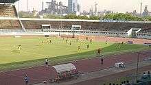
JRD Tata Sports Complex has an international standard multi-use stadium and an eight-lane monosynthetic track. It is primarily used for football and athletics but it has facilities for various other sports including archery, basketball, field hockey, swimming, table tennis, tennis, volleyball as well as a modern gymnasium, are available at the complex. The stadium hosted the women football competition & archery event of the 34th National Games in 2011.
Keenan Stadium has a backdrop of the Dalma Hills, providing a picturesque setting for cricket. The stadium is named after John Lawrence Keenan, a former general manager at Tata Steel. The stadium hosted its 1st International One Day Cricket match on 7 December 1983 in which India lost to the touring West Indies Team. Many other International matches have been played here in which India has won only one match against South Africa in 1999–2000.
Tata Football Academy (TFA) was started in 1987 to nurture budding Indian footballers and raise the standard of Indian football. TFA is a football club in Jamshedpur, sponsored by Tata Steel. Today, Tata Football Academy is one of the premier football breeding grounds in India.
Tata Archery Academy: archery is a sport indigenous to the tribal people of Chhotanagpur and Santhal Pargana. Tata Steel has pursued and nurtured the local tribals and provided them with facilities and training to bring them up to international competition standards in archery. Its students have attributed a lot of fame to the institute by bringing in many medals in National and International competitions.
Jamshedpur has two golf courses—the Beldih Golf Course and the Golmuri Golf Course. Both these courses are at the heart of the city. The biggest is the Beldih Golf Course which is around 6000 yards. The Golmuri Golf Course although smaller is also challenging. They together hold the annual Tata Open Golf Tournament which is an event held under the support of the Professional Golf Tour of India. The tournament was started in 2002.

Jamshedpur also has The Jamshedpur Gliding Club and The Jamshedpur Co-operative Flying club.
Media
Print media
English, Hindi, and Bengali newspapers are published from the city, including Dainik Jagran, The Telegraph, Dainik Bhaskar, Hindustan Times, Times of India, Prabhat Khabar and The Avenue Mail.
Notable people
- Priyanka Chopra, former Miss World and actress
- R. Madhavan, actor
- Tanushree Dutta, former Femina Miss India and actress
- Imtiaz Ali (director)
- Pratyusha Banerjee
- Saurabh Tiwary
- Shomu Mukherjee
- Varun Aaron
- Simone Singh, Indian television actress
- Shilpa Rao, Singer
See also
- Economy and Industries of Jamshedpur
- Tata Steel
- Tatanagar Railway Station
- List of mobile network operators in Jamshedpur
References
- ↑ "Jamshedpur city total area".
- ↑ "Census 2011". The Registrar General & Census Commissioner, India. Retrieved 21 May 2016.
- ↑ "Report of the Commissioner for linguistic minorities: 50th report (July 2012 to June 2013)" (PDF). Commissioner for Linguistic Minorities, Ministry of Minority Affairs, Government of India. Retrieved 26 December 2014.
- ↑ http://www.bihardays.com/jharkhands-11-second-languages-will-create-new-jobs-enrich-national-culture/
- ↑ https://www.worldsteel.org/statistics/top-producers.html
- ↑ "World's fastest growing urban areas (1)". City Mayors. 17 May 2012. Retrieved 13 July 2012.
- ↑ Dutta, Maya (1977). Jamshedpur: the growth of the city and its regions. Asiatic Society.
- ↑ "Page Not Found". Retrieved 26 July 2016.
- 1 2 "Sakchi- an end to the search of Iron-ore in Steel making process". Tatasteel100.com. 27 February 1908. Retrieved 13 July 2012.
- ↑ "History of Steel Making Begins, Gradual Development of Indian Steel Company". Tatasteel100.com. 16 February 1912. Retrieved 13 July 2012.
- ↑ "Jamshedpur - More details - Tourist Destinations in India - Lakes, Waterfalls, Beaches, Monuments, Museums and parks at Jamshedpur- By". Tripsguru.com. Retrieved 13 July 2012.
- ↑ "A hundred years of Tata steel". domain-b.com. Retrieved 13 July 2012.
- ↑ 16 January 2006 at 0047 hrs IST (16 January 2006). "Jamshedpur citizens do not want municipal corporation". Financialexpress.com. Retrieved 13 July 2012.
- ↑ "Push to civic makeover". The Telegraph. Calcutta, India. 13 June 2003.
- ↑ "Jamshedpur on a renewal mission - Business News - IBNLive". Origin-www.ibnlive.com. 6 September 2006. Retrieved 13 July 2012.
- ↑ "Jamshedpur India - Jamshedpur Jharkhand, Jamshedpur City, Jamshedpur Guide, Jamshedpur Location". Iloveindia.com. Retrieved 13 July 2012.
- ↑ "Site Information for 42799 in Jamshedpur, BR, India". 22.816667;86.183333: Weather.gladstonefamily.net. 21 June 2012. Retrieved 13 July 2012.
- ↑ Archived 9 April 2009 at the Wayback Machine.
- ↑ kanika das (1 January 1970). "Jadugoda -Mosabani Range". Maps.google.co.in. Retrieved 13 July 2012.
- ↑ "Profile of Adityapur Industrial Area & AIADA". Aiadaonline.com. Retrieved 13 July 2012.
- ↑ "Jamshedpur Geography". Mapsofindia.com. Retrieved 13 July 2012.
- ↑ ":: ASC :: Seismicity of Jharkhand, India". Asc-india.org. Retrieved 13 July 2012.
- ↑ "Jamshedpur Climatological Table Period: 1971–2000". India Meteorological Department. Retrieved 22 April 2015.
- ↑ "Ever recorded Maximum and minimum temperatures up to 2010". India Meteorological Department. Archived from the original on 21 May 2013. Retrieved 22 April 2015.
- ↑ "Census of India 2001: Data from the 2001 Census, including cities, villages and towns (Provisional)". Census Commission of India. Archived from the original on 16 June 2004. Retrieved 1 November 2008.
- ↑ http://www.censusindia.gov.in/2011-prov-results/paper2/data_files/India2/1.%20Data%20Highlight.pdf
- ↑ http://www.censusindia.gov.in/2011-prov-results/paper2/data_files/india2/Million_Plus_UAs_Cities_2011.pdf
- ↑ Gopal, Madan (1990). K.S. Gautam, ed. India through the ages. Publication Division, Ministry of Information and Broadcasting, Government of India. p. 179.
- ↑ "Tata Steel bags Prime Minister's Trophy for best performing Integrated Steel Plant". Tata Steel. 27 August 2012. Retrieved 2 February 2015.
- ↑ Singh, Ankush (6 November 2008). "Slowdown squeeze on Tatas - Five-day holiday to halt assembly of commercial vehicles". The Telegraph. Calcutta, India.
- ↑ "Tata Steel and TRIL inks JV for Jamshedpur airport - 211947". Steelguru.com. 29 June 2011. Retrieved 20 May 2013.
- ↑ Archived 4 October 2011 at the Wayback Machine.
- ↑ "Tatas candid on airport land poser". The Telegraph. Calcutta, India. 3 August 2012.
- ↑ "Jamshedpur at a Glance". Tata Steel Growth Shop. Retrieved 3 July 2007.
- ↑ "Training Facility". Adityapur Industrial Area Development Authority. Retrieved 3 July 2007.
- ↑ "60 Years of Dedication to the Future". National Metallurgical Laboratory. Retrieved 21 May 2010.
- ↑ "Learning and Development". Careers at Tata Steel. Retrieved 21 May 2010.
- ↑ Sarkar, Soma Basu (31 January 2007). "Bookworms' paradise". The Telegraph. Calcutta, India. Retrieved 21 May 2010.
External links
| Wikimedia Commons has media related to Jamshedpur. |
- Website of the District Administration
- Fact File on Jamshedpur
-
 Jamshedpur travel guide from Wikivoyage
 - Satellite images of Jamshedpur
- Photo essay on Tata City/Jamshedpur, Galli Magazine
- jamshedpurcity - A Portal of Jamshedpur city.
- JsrLive - A City Portal for Jamshedpur
- MyJamshedpur.com - Complete information about Jamshedpur (or Tatanagar) city