Wabuska, Nevada
Wabuska is an unincorporated community in Lyon County, Nevada, United States. The zip code is 89447, which it shares with nearby Yerington.
Wabuska (Washo language, White Grass) was established in the early 1870s. A post office was opened on September 18, 1974.[1] In 1881, the town served as the principal Mason Valley supply center on the newly constructed Carson and Colorado Railroad of a line that went from Hazen to Mina.[1] When copper was discovered in Mason Valley, the town became the northern terminus of the new Nevada Copper Belt Railroad, built 1909-1911. Wabuska waned with declining mining activity in the 1920s.[2]
Geography
Wabuska's latitude is 39.143N and the longitude is -119.182W. Wabuska's elevation is 4,295 feet above sea level.
Climate
Wabuska experiences a desert climate and has a Köppen Climate Classification of Bwk.[3]
| Climate data for Wabuska, Nevada | |||||||||||||
|---|---|---|---|---|---|---|---|---|---|---|---|---|---|
| Month | Jan | Feb | Mar | Apr | May | Jun | Jul | Aug | Sep | Oct | Nov | Dec | Year |
| Average high °C (°F) | 8 (46) |
11 (52) |
16 (60) |
19 (66) |
24 (75) |
29 (85) |
34 (94) |
33 (92) |
28 (83) |
21 (70) |
13 (56) |
8 (46) |
21 (69) |
| Average low °C (°F) | −9 (16) |
−7 (20) |
−3 (26) |
−1 (31) |
4 (39) |
8 (46) |
11 (52) |
9 (49) |
4 (40) |
−1 (30) |
−6 (22) |
−9 (15) |
0 (32) |
| Average precipitation mm (inches) | 13 (0.5) |
13 (0.5) |
13 (0.5) |
10 (0.4) |
15 (0.6) |
10 (0.4) |
5 (0.2) |
5 (0.2) |
8 (0.3) |
10 (0.4) |
10 (0.4) |
10 (0.4) |
119 (4.7) |
| Source: Weatherbase [4] | |||||||||||||
References
- 1 2 Carlson, Helen S. (1974). Nevada place names : a geographical dictionary. Reno: University of Nevada Press. p. 240. ISBN 0-87417-094-X.
- ↑ Wabuska, Nevada Historical Marker 113
- ↑ Climate Summary for Wabuska, Nevada
- ↑ "Weatherbase.com". Weatherbase. 2013. Retrieved on September 8, 2013.
External links
- http://www.epodunk.com/cgi-bin/genInfo.php?locIndex=17756
- http://www.hometownlocator.com/City/Wabuska-Nevada.cfm
Coordinates: 39°08′38″N 119°11′00″W / 39.14389°N 119.18333°W
Municipalities and communities of Lyon County, Nevada, United States | ||
|---|---|---|
| Cities | 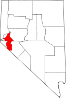 | |
| CDPs | ||
| Other unincorporated communities | ||
| Ghost towns | ||
| Indian reservation | ||