Mina, Nevada
| Mina, Nevada | |
|---|---|
| Census-designated place | |
|
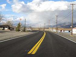
Mina, Nevada in 2011 | |
 Mina Mina is located in the Tonopah Basin of Nevada | |
| Coordinates: 38°23′26″N 118°6′31″W / 38.39056°N 118.10861°WCoordinates: 38°23′26″N 118°6′31″W / 38.39056°N 118.10861°W | |
| Country | United States |
| State | Nevada |
| County | Mineral |
| Area | |
| • Total | 2.4 sq mi (6.2 km2) |
| • Land | 2.4 sq mi (6.2 km2) |
| • Water | 0 sq mi (0 km2) |
| Population (2010) | |
| • Total | 155 |
| • Density | 65/sq mi (25/km2) |
| Time zone | Pacific (PST) (UTC-8) |
| • Summer (DST) | PDT (UTC-7) |
| ZIP codes | 89422 |
| Area code(s) | 775 |
| FIPS code | 32-46800 |
| GNIS feature ID | 0842148 |
Mina is a census-designated place in Mineral County in west-central Nevada, United States. It is located along U.S. Route 95 (38° 23' 25" N 118° 06' 30" W) at an elevation of 4,560 feet (1,390 m). The 2010 population was 155.[1]
History
Mina was founded as a railroad town in 1905 and was named for Ferminia Sarras, a large landowner and famed prospector known as the 'Copper Queen.'[2] The Nevada & California Railway, a division of Southern Pacific Railroad, had a station in the town. The railroad is long gone, but at one time a local shuttle called the "Slim Princess" allowed Native Americans to ride for free on top of the railcars, and passengers and crew would shoot wild game such as jack rabbits, ducks and sage hens from the open windows. The train moved slow enough that hunters had time to retrieve their game and hop back on board.

Gee Jon and Hughie Sing were convicted of the August 27, 1921, Mina, Nevada murder of Tom Quong Kee and, as a result, Gee Jon, a 29-year-old member of the Hop Sing Tong, became the first person in the world executed by lethal gas. The execution was at the Nevada State Prison on February 8, 1924.[3]
Sodaville was an earlier town and station on the Carson and Colorado Railway, about 4 miles (6 km) south of Mina. The Sodaville post office was active from October 9, 1882, until March 31, 1917, when its operations were moved to Mina.[4] The Mina post office was established September 25, 1905.[5] Mina was also served by the Tonopah and Goldfield Railroad.
Name
Name is derived from a Spanish word meaning 'mine.'[5]
Geography
Mina in the Soda Spring Valley of eastern Mineral County along U.S. Route 95, 32 miles (51 km) southeast of Hawthorne and 70 miles (110 km) northwest of Tonopah. According to the U.S. Census Bureau, the Mina CDP has an area of 2.4 square miles (6.2 km2), all land.[1]
Climate
The Köppen Climate System classifies the weather in this area as semi-arid, abbreviated BSk. This climate type occurs primarily on the periphery of true deserts in low-latitude semiarid steppe regions.[6]
| Climate data for Mina, Nevada | |||||||||||||
|---|---|---|---|---|---|---|---|---|---|---|---|---|---|
| Month | Jan | Feb | Mar | Apr | May | Jun | Jul | Aug | Sep | Oct | Nov | Dec | Year |
| Average high °C (°F) | 8 (46) |
11 (52) |
15 (59) |
19 (67) |
24 (76) |
31 (87) |
36 (96) |
34 (93) |
29 (85) |
22 (72) |
14 (57) |
8 (47) |
21 (70) |
| Average low °C (°F) | −6 (21) |
−4 (25) |
−1 (30) |
2 (36) |
7 (45) |
12 (54) |
16 (61) |
14 (58) |
9 (48) |
3 (38) |
−2 (28) |
−6 (21) |
4 (39) |
| Average precipitation mm (inches) | 10 (0.4) |
10 (0.4) |
10 (0.4) |
13 (0.5) |
15 (0.6) |
10 (0.4) |
8 (0.3) |
8 (0.3) |
8 (0.3) |
10 (0.4) |
8 (0.3) |
8 (0.3) |
114 (4.5) |
| Source: Weatherbase [7] | |||||||||||||
See also
- Thenardite, a sodium sulfate mineral, Na2SO4, found at Sodaville
References
- 1 2 "Geographic Identifiers: 2010 Demographic Profile Data (G001): Mina CDP, Nevada". U.S. Census Bureau, American Factfinder. Retrieved January 25, 2013.
- ↑ “A Mine of Her Own: Women Prospectors in the American West, 1850-1950 By Sally Zanjani"
- ↑ "Asian Pacific American Historical Timeline Details (1920 to 1929)". USAsians.net. Retrieved 25 July 2011.
- ↑ Sodaville at SilverStateGhostTowns.com
- 1 2 . p. 168. ISBN 0-87417-094-X. Missing or empty
|title=(help) - ↑ Climate Summary for Mina, Nevada
- ↑ "Weatherbase.com". Weatherbase. 2013. Retrieved on September 8, 2013.
External links
Municipalities and communities of Mineral County, Nevada, United States | ||
|---|---|---|
| CDPs | 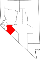 | |
| Unincorporated community | ||
| Indian reservation | ||
| Ghost towns |
| |