Tizard Bank

| Part of a series on the |
| Spratly Islands |
|---|
 Spratly Islands military occupations map |
| Related articles |
| Confrontations |
| Military occupations |
|
|
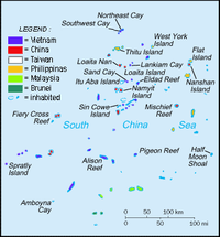
The Tizard Bank, in Chinese known as 郑和群礁 or Zhenghe Qunjiao, 10°15′N 114°30′E / 10.250°N 114.500°ECoordinates: 10°15′N 114°30′E / 10.250°N 114.500°E is a partially sunken atoll and one of the significant maritime features in the Spratly Islands in the northern part of the Group.
It was named after Thomas Henry Tizard (1839 – 17 February 1924) a British oceanographer and surveyor who surveyed the Bank aboard HMS Rifleman in the 1860s. in 1947 the Republic of China government gave the Bank the name Zheng He Archipelago after the famous Ming-era admiral, although there is no evidence that he ever visited Tizard Bank.
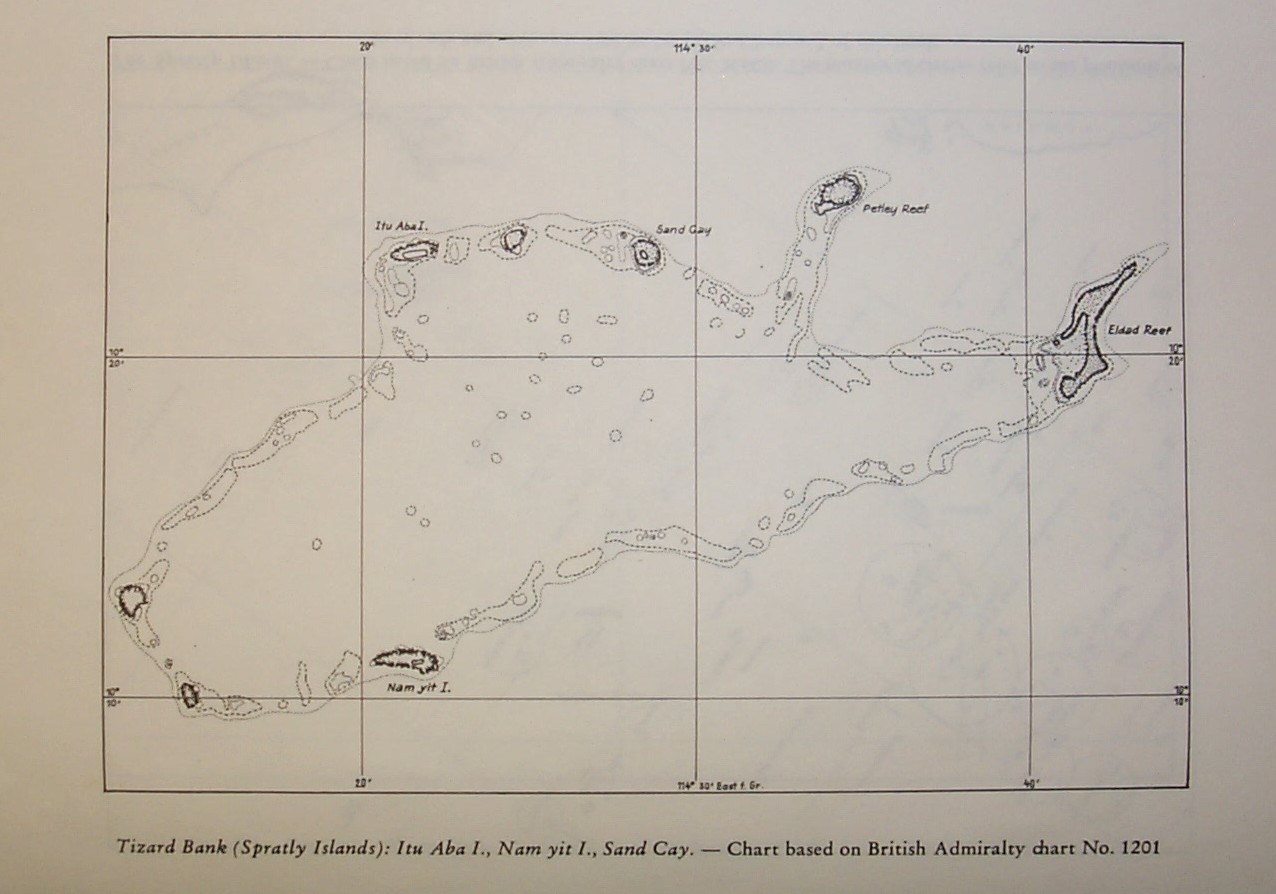
The Bank raises steeply from surrounding depths ranging from 500 to 700 meters. It is 32.05 nautical miles (59.36 km; 36.88 mi) in length, and extends from the Gaven Reefs to the NW of Dangerous Ground.[1][2] The Atoll is up to 11.36 nautical miles (21.04 km; 13.07 mi) wide. The total area is 953 km², and the greatest depth of the central lagoon is 80 meters.[3] The central lagoon generally is 10 to 40 meters deep,[4] although many coral heads have much shallower depths. There are several entrances into the lagoon.
The bank contains a number of features along the rim of the reef, including shoals, reefs, islands, and cays, numerous wrecks, some lighthouses, and an ammunition dumping ground.[5] Several coral heads with depths of 6-12m lie in the lagoon, and depths "3.7m less than charted can be expected. ... Mariners should navigate with extreme caution in this vicinity."[1]
Features in the area include:[1]
- Namyit Island (10°11'N 114°22'E) on the S side of the bank is about 12 miles S of Itu Aba. It is 18m high and covered with small trees and brush.
- Gaven Reefs (10°12'N 114°13'E) consists of two reefs which cover at high tide and lie 7 miles W and 8.5 miles WNW, respectively, of Namyit Island.
- Sand Cay
- Itu Aba Island (10°23'N 114°22'E), lies on the NW corner of the bank
- Zhongzhou Reef lies between Itu Aba and Sand Cay
- Petley Reef, which dries 0.9m, is about 1 mile in extent and lies on the N side of the bank.
- Eldad Reef, 7 miles ESE of Petley Reef, is the easternmost drying reef of the group. The reef is 4.5 miles long with the middle section having a depth of about 1.2m, located at the NE end of the reef.
(Gaven Reef South)
(Gaven Reef)
(Itu Aba)
(Sand Cay)
(Petley Reef)
(Eldad Reef)
(Namyit)
It is neighboured by the Loaita Bank to the North, Discovery Great Reef to the west, and the Union Banks to the south.
References
- 1 2 3 US NGA (15 Nov 2014). "Pub. 161, Sailing Directions (Enroute) South China Sea and the Gulf of Thailand, Fifteenth Edition, 2014." (PDF). msi.nga.mil. pp. 9–10, (Sections 1.24 – 1.26).
- ↑ NGA Chart 93044 shows the area NW of Dangerous Ground.
Note that this chart incorrectly labels the bank as the Southhampton Reefs - the Southampton Reefs are further east (10°11'N 115°17'E) - and also mis-spells Petley Reef as Peltey Reef. - ↑ Atoll Area, Depth and Rainfall
- ↑ Wolfgang Schippke: The Tizard Bank, a large reef in the Spratly Group
- ↑ The ammunition dumping ground is about 6.7 nautical miles (12.4 km; 7.7 mi) to the north in water 1900m deep.