Sand Cay
| Disputed island | |
|---|---|
| Geography | |
 | |
| Location | South China Sea |
| Coordinates | 10°22′42″N 114°28′34″E / 10.3783°N 114.476°ECoordinates: 10°22′42″N 114°28′34″E / 10.3783°N 114.476°E |
| Archipelago | Spratly Islands |
| Administered by | |
| Vietnam | |
| Claimed by | |
| People's Republic of China | |
| Philippines | |
| Republic of China (Taiwan) | |

| Part of a series on the |
| Spratly Islands |
|---|
 Spratly Islands military occupations map |
| Related articles |
| Confrontations |
| Military occupations |
|
|
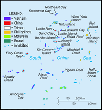
Sand Cay 10°23′N 114°29′E / 10.383°N 114.483°E, also known as Son Ca Island (Tagalog: Bailan; Chinese: 敦谦沙洲; pinyin: Dunqian Shazhou; Vietnamese: đảo Sơn Ca) is a cay in the Tizard Bank of the Spratly Islands in the South China Sea. With an area of 7 hectares (17 acres), it is the ninth largest, and the fourth largest Vietnamese-occupied, of the Spratly Islands. The island has been occupied by Vietnam since 1974, (first by the Republic of Vietnam, then by the Socialist Republic of Vietnam after 1975). It is also claimed by the People's Republic of China, the Republic of China (Taiwan), and the Philippines.
Geography
Part of the Tizard Bank,[1] Sand Cay lies 6.2 nautical miles (11.5 km; 7.1 mi) east of Itu Aba Island, which is occupied by the Republic of China (Taiwan). It is 450 metres (1,480 ft) long, 102 metres (335 ft) wide, and has an elevation of 3.5 metres (11 ft) to 3.8 metres (12 ft) at low tide.[2] There is a 41 metres (135 ft) high light house on the islet.[3] Sand Cay is commonly confused with Sandy Cay which is a sandy shoal (coral reef) near Thitu Island.
Ecology
Sand Cay has no source of natural fresh water, but the islet's coral sand is covered with a thin layer of fertile humus mixing with guano. The vegetation mainly composes of Barringtonia asiatica, Ipomoea pes-caprae and Casuarinaceae's species as well as some kinds of grass.[2] In recent years, islanders have cultivated fruit trees such as pomelo, jackfruit, dragonfruit, sugar-apple and guava.[4] Sand Cay is usually visited by seabirds, and its surrounding water is rich with fish, sea snails and sea cucumbers.[2]
See also
- Great wall of sand
- List of maritime features in the Spratly Islands
- Spratly Islands dispute
- Truong Sa District
References
- ↑ "Digital Gazetter of Spratly Islands". Retrieved 2008-03-22.
- ↑ (Vietnamese)Phạm Thanh Hà; Lưu Phương Mai (May 9, 2011). "Kí sự Trường Sa - kì 3: Nơi anh đến là biển xa...". Nhân dân online. Retrieved March 22, 2013.
- ↑ (Vietnamese) Nguyễn Đình Quân (December 27, 2011). "Sơn Ca Xanh". Tiền phong online. Retrieved March 22, 2013.