Union Banks
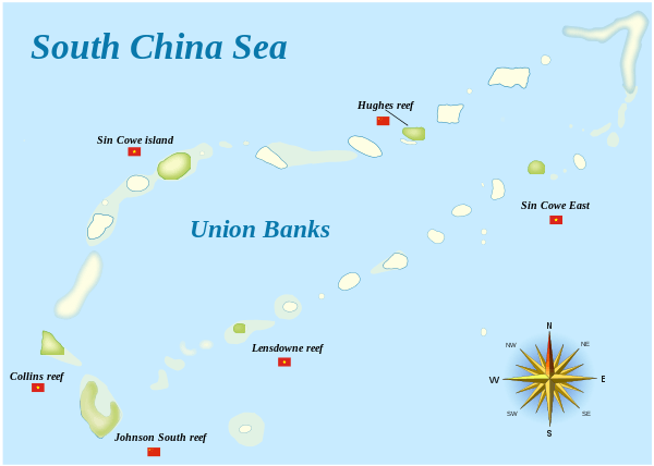
Map of Union Banks

Vietnamese structure on Collins Reef (Đá Cô Lin)
Union Banks is a large drowned atoll in the center of Spratly Islands in South China Sea, 230 kilometers[1] west of the Philippine coast, containing islands and reefs whose ownership remains disputed and controversial.[2] The closest atoll is Tizard Bank, 25 kilometers due north of Union Banks. There are only two natural islands on the rim of the reef, Sin Cowe Island and Sin Cowe East Island.
The atoll is 55 kilometers long from Johnson South Reef in the southwest to Whitson Reef in the northeast, and up to 15 kilometers wide. Its total area measures 461 km². The central lagoon is up to 53 meters deep.[3]
Islands and reefs comprising Union banks
Union banks consists of the following islands and reefs, clockwise starting in the southwest corner:[4][5]
.png)
Chigua Jiao (Johnson South Reef)
Gent Reef
Loveless Reef
Sinh Tồn (Sin Cowe)
Edmund Reef
McKennan Reef
Dōngmén Jiāo (Hughes Reef)
Hallet Reef
Holiday Reef
Empire Reef
Whitson Reef
Ross Reef
Sinh Tồn Đông (Sin Cowe East)
Bamford Reef
Tetley Reef
Grierson Reef
Jones Reef
Higgins Reef
Đá Len Đao (Landsdowne Reef)
See also
References
- ↑ "China expanding presence on Mabini reef". ABS CBN News / Kyodo News. 13 May 2014. Retrieved 20 May 2014.
- ↑ Dato Mohammad, Brigadier General (1991). The Conflicting Claims in the South China Sea. PA, USA: U.S. Army War College.
- ↑
- ↑ China Sea Pilot - Volume II - NP 31. Taunton: United Kingdom Hydrographic Office. 2012.
- ↑ "Digital Gazetteer of Spratly Islands". www.southchinasea.org. Archived from the original on 2007-07-17. Retrieved 2008-02-08.
- Version dated 19 August 2011 is available at: "Digital Gazetteer of Spratly Islands". www.southchinasea.org. 19 August 2011. Retrieved 5 June 2014.This list includes the names of all Spratly features known to be occupied and/or above water at low tide.
This article is issued from Wikipedia - version of the 9/30/2016. The text is available under the Creative Commons Attribution/Share Alike but additional terms may apply for the media files.