Irving Reef
| Disputed island | |
|---|---|
 | |
| Irving Reef | |
| Geography | |
 | |
| Location | South China Sea |
| Coordinates | 10°52′N 114°55′E / 10.86°N 114.92°ECoordinates: 10°52′N 114°55′E / 10.86°N 114.92°E |
| Archipelago | Spratly Islands |
| Administered by | |
| Philippines | |
| Municipality | Kalayaan, Palawan |
| Claimed by | |
| People's Republic of China | |
| Philippines | |
| Republic of China (Taiwan) | |
| Vietnam | |
| Part of a series on the |
| Spratly Islands |
|---|
 Spratly Islands military occupations map |
| Related articles |
| Confrontations |
| Military occupations |
|
|
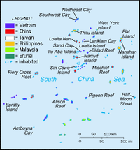
Irving Reef (Filipino: Balagtas Reef, Chinese: 火艾礁; pinyin: Huǒài jiāo, Vietnamese: đá Cá Nhám) is a coral reef in the Spratly Islands, South China Sea. It is occupied by the Philippines as part of the Kalayaan Islands,[1][2] but is also claimed by the People's Republic of China, the Republic of China (Taiwan) and Vietnam.
The reef is 11 nautical miles southwest of West York Island (known as Likas Island in the Philippines). It is 2 nautical miles in length.[3] There is a sand cay near the northern extremity.[4]
The Filipino name Balagtas Reef is named after the Filipino poet Francisco Balagtas.
References
- ↑ "Smart maintains GSM service on Pag-asa Is.". The Philippine Star. 2011-07-30. Retrieved 2012-08-14.
- ↑ Esplanada, Jerry (2011-06-06). "Manila's claim in Spratlys within West Philippine Sea". Philippine Daily Inquirer. Retrieved 2012-08-14.
- ↑ D. J. Hancox, John Robert Victor Prescott, A Geographical Description of the Spratly Islands and an Account of Hydrographic Surveys Amongst Those Islands (International Boundaries Research Unit, 1995, ISBN 978-1897643181, p. 7. Excerpts available at Google Books.
- ↑ Sailing Directions 161 (Enroute) - South China Sea and the Gulf of Thailand (13 ed.). Bethesda, Maryland: National Geospatial-Intelligence Agency. 2011. p. 10.
This article is issued from Wikipedia - version of the 10/11/2016. The text is available under the Creative Commons Attribution/Share Alike but additional terms may apply for the media files.