Great wall of sand
| Part of a series on the |
| Spratly Islands |
|---|
 Spratly Islands military occupations map |
| Related articles |
| Confrontations |
| Military occupations |
|
|
The "great wall of sand" is a name used by the media for a series of land reclamation projects undertaken by the PRC since late 2013 in the South China Sea – particularly in the Spratly islands group – in order to strengthen PRC territorial claims to the region demarcated by the "nine-dash line".[1][2][3][4] They are created by dredging sand onto coral reefs to create artificial islands which are then concreted to make permanent structures. By the time of the 2015 Shangri-La Dialogue, over 810 hectares (2,000 acres) of new land had been created.[5] By June 2015, the land reclamation had reached 3,200 acres (1,300 ha) (13km2) (5 square miles).[6]
China states that the construction is for "improving the working and living conditions of people stationed on these islands"[7] and that, "China is aiming to provide shelter, aid in navigation, weather forecasts and fishery assistance to ships of various countries passing through the sea."[8] Defence analysts IHS Janes states that it is a "methodical, well planned campaign to create a chain of air and sea-capable fortresses".[9] These "military-ready" installations include sea-walls and deep-water ports, barracks, and notably including runways on Fiery Cross Reef[10][11] and Johnson South Reef.[1] Aside from geo-political tensions, concerns have been raised about the environmental impact on fragile reef ecosystems through the destruction of habitat, pollution and interruption of migration routes.[12]
There is no known official term for the projects; the phrase "great wall of sand" was first used by Harry Harris, commander of the US Pacific Fleet, in March 2015.[13]
Other countries in the region are also undertaking, on a far smaller scale, similar operations.[14] The U.S. Pentagon's estimates in 2015 for the amount of reclaimed land was: China (2,900 acres), Vietnam (80 acres), Malaysia (70 acres), the Philippines (14 acres) and Taiwan (8 acres).[15]
Reclamation activities
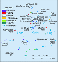
The Asia Maritime Transparency Initiative's "Island tracker" lists the following locations as sites of island reclamation activities:[16]
| English name | Chinese name[^] | Filipino name | Vietnamese name | Facilities added | Reclaimed area | Ref. |
|---|---|---|---|---|---|---|
| Cuarteron Reef | Huáyáng Jiāo (华阳礁) | Calderon Reef | Đá Châu Viên | Access channel, Breakwaters, Multiple support buildings, New helipad, Possible radar facility | 0.231 km2 (57 acres) | |
| Fiery Cross Reef | Yǒngshǔ Jiāo (永暑礁) | Kagitingan Reef | Đá Chữ Thập | Airstrip, Harbor, Multiple cement plants, Multiple support buildings, Piers | 2.740 km2 (677 acres) | |
| Gaven Reef | Nánxūn Jiāo (南薰礁) | Burgos Reefs | Đá Ga Ven | Access channel, Anti-air guns, Communications equipment, Construction support structure, Defensive tower, Naval guns | 0.136 km2 (34 acres) | |
| Hughes Reef | Dōngmén Jiāo (东门礁) | — | Đá Tư Nghĩa | Access channel, Coastal fortifications, Four Defensive Towers, Harbor, Multi-level military facility | 0.760 km2 (188 acres) | |
| Johnson South Reef | Chìguā Jiāo (赤瓜礁) | Mabini Reef | Đá Gạc Ma | Access channel, Concrete plant, Defensive Towers, Desalination pumps, Fuel dump, Multi-level military facility, Possible radar facility | 0.109 km2 (27 acres) | |
| Mischief Reef | Měijì Jiāo (美济礁) | Panganiban Reef | Đá Vành Khăn | Access channel, Fortified Seawalls | 5.580 km2 (1,379 acres) | |
| Subi Reef | Zhǔbì Jiāo (渚碧礁) | Zamora Reef | Đá Xu Bi | Access channel, Piers, Airstrip | 3.950 km2 (976 acres) |
^ The official Chinese names still use Jiāo (礁) meaning "reef", as previously in e.g. the Chinese: 赤瓜礁海战; pinyin: Chìguā jiāo hǎizhàn, the "Johnson South reef naval battle". Unofficially, the term Dǎo (岛) meaning "island" is gaining popularity. So the place of that naval battle may be called as Chinese: 赤瓜岛; pinyin: Chìguā Dǎo casually.
Total reclaimed area on these 7 reefs: 13.5 km2 (3,300 acres)
| Audio | |
|---|---|
|
| |
| Video | |
|
| |
|
|
Machinery
China used hundreds of dredges and barges including a giant self-propelled dredger, the Tian Jing Hao. Built in 2009 in China, the vessel, Tian Jing Hao, is a 127 m-long seagoing cutter suction dredger designed by German engineering company Vosta LMG; (Lübecker Maschinenbau Gesellschaft (de)). At 6,017 gross tonnes, with a dredging capacity of 4500m3/h, it is credited as being the largest of its type in Asia. It has been operating on Cuarteron Reef, the Gaven Reefs, and at Fiery Cross Reef.[17]
Strategic importance
More than half of the world's annual merchant fleet tonnage passes through the Strait of Malacca, Sunda Strait, and Lombok Strait, with the majority continuing on into the South China Sea. Tanker traffic through the Strait of Malacca leading into the South China Sea is more than three times greater than Suez Canal traffic, and well over five times more than the Panama Canal.[18] The People's Republic of China (PRC) has stated its unilateral claim to almost the entire body of water.[19]
Legal issues
- Unilateral declared sovereignty.
Territorial waters of an artificial island
- Artificial islands built on a submerged feature
As the Mischief Reef and Subi Reef are under the water, they are considered by the Third United Nations Conference on the Law of the Sea (UNCLOS III) as "sea bed" in "international waters". Although the PRC had ratified a limited[20] UNCLOS III not allowing innocent passage of war ships, according the UNCLOS III, features built on the sea bed cannot have territorial waters.[20]
- Artificial islands built on a rock
- Artificial islands built in disputed waters
Environmental legal issues
The PRC has ratified UNCLOS III;[20] the convention establishes general obligations for safeguarding the marine environment and protecting freedom of scientific research on the high seas, and also creates an innovative legal regime for controlling mineral resource exploitation in deep seabed areas beyond national jurisdiction, through an International Seabed Authority and the Common heritage of mankind principle.[21]
Regional concept
According to Chinese sources, the concept was invented in 1972 by the Bureau of Survey and Cartography of Vietnam under the Office of Premier Phạm Văn Đồng which printed out "The World Atlas" and said "The chain of islands from the Nansha and Xisha Islands to Hainan Island, Taiwan Island, the Penghu Islands and the Zhoushan Islands are shaped like a bow and constitute a Great Wall defending the China mainland."[22]
Reactions
States
-
 Australia – Opposed to "any coercive or unilateral actions to change the status quo in the South and East China Sea",[23] Australia continues to fly routine surveillance operations and exercise the right to freedom of navigation in international airspace "in accordance with the international civil aviation convention, and the United Nations Convention on the Law of the Sea."[24]
 -
 China – Following confrontations between US P8-A Poseidon aircraft and the Chinese Navy over the constructions in May 2015,[25] China stated that it has "...the right to engage in monitoring in the relevant air space and waters to protect the country's sovereignty and prevent accidents at sea."[26]
  South Korea – No official stance, maintains an "...increasingly notable silence on freedom of navigation in the South China Sea".[27][28]
-
 USA – The construction is considered to be a key motivating factor behind the Obama administration's "Asia Pivot" military strategy.[29] It believes "...that China’s activities in the South China Sea are driven by nationalism, part of a wider strategy aimed at undercutting US influence in Asia."[5] It has declared that it would operate military aircraft in the region "'...in accordance with international law in disputed areas of the South China Sea' and would continue to do so 'consistent with the rights freedoms and lawful uses of the sea.'"[26]
- Since October 2015, when the USS Lassen passed close to man-made land built upon Subi Reef,[30][31] the US has been conducting Freedom of navigation operations (FONOP) with Arleigh Burke-class Guided missile destroyers approximately every three months near the artificial islands.[32]
Organizations
- ASEAN – The Association of Southeast Asian Nations stated that the constructions "may undermine peace, security and stability" in the region as well as having strongly negative impact on the marine environment and fishery stocks.[33]
- G7 – In a "Declaration on maritime security" before the 41st G7 summit, the G7 stated that, "We continue to observe the situation in the East and South China Seas and are concerned by any unilateral actions, such as large scale land reclamation, which change the status quo and increase tensions. We strongly oppose any attempt to assert territorial or maritime claims through the use of intimidation, coercion or force.[34]
- In July 2016, the Permanent Court of Arbitration in The Hague ruled that China has no historic title over the area.[35]
Ecological impact
Aside from geo-political tensions, concerns have been raised about the environmental impact on fragile reef ecosystems through the destruction of habitat, pollution and interruption of migration routes.[12] These new islands are built on reefs previously 1m below the level of the sea. For back-filling these 7 artificial islands, a total area of 13.5 million m2, to the height of few meters, China had to destroy surrounding reefs and pumping 40 or 50 million m3 of sand and corals, resulting in significant and irreversible damage to the environment. Frank Muller-Karger, professor of biological oceanography at the University of South Florida, said sediment “can wash back into the sea, forming plumes that can smother marine life and could be laced with heavy metals, oil and other chemicals from the ships and shore facilities being built.” Such plumes threaten the biologically diverse reefs throughout the Spratlys, which Dr. Muller-Karger said may have trouble surviving in sediment-laden water.[36]
Rupert Wingfield-Hayes visited the vicinity of the Philippine-controlled island of Pagasa, by plane and boat, said he saw Chinese fishermen poaching and destroying the reefs on a massive scale. As he saw Chinese fishermen poaching endangered species like massive giant clam, he noted “None of this proves China is protecting the poachers. But nor does Beijing appear to be doing anything to stop them. The poachers we saw showed absolutely no sign of fear when they saw our cameras filming them”. He concludes: “However shocking the reef plundering I witnessed, it is as nothing compared to the environmental destruction wrought by China's massive island building programme nearby. The latest island China has just completed at Mischief Reef is more than 9km (six miles) long. That is 9km of living reef that is now buried under millions of tonnes of sand and gravel.” [37]
A famous 2014 United Nations Environment Programme (UNEP) report said: "Sand is rarer than one thinks".[38]
The average price of sand imported by Singapore was US $3 per tonne from 1995 to 2001, but the price increased to US $190 per tonne from 2003 to 2005.[38] Although the Philippines and the PRC had both ratified the UNCLOS III,[20] in the case of and Johnson South Reef, Hughes Reef, Mischief Reef, the PRC dredged sand for free in the EEZ the Philippines had claimed from 1978[39] arguing this is the "waters of China's Nansha Islands."
Although the consequences of substrate mining are hidden, they are tremendous.[38] Aggregate particles that are too fine to be used are rejected by dredging boats, releasing vast dust plumes and changing water turbidity...[38]
John McManus, a professor of marine biology and ecology at the University of Miami’s Rosenstiel School of Marine and Atmospheric Science, said: “The worst thing anyone can do to a coral reef is to bury it under tons of sand and gravel.” “There are global security concerns associated with the damage. It is likely broad enough to reduce fish stocks in the world’s most fish-dependent region,” He explained that “[the reason] the world has heard little about the damage inflicted by the People's Republic of China to the reefs is that the experts can’t get to them.” and noted “I have colleagues from the Philippines, Taiwan, PRC, Vietnam and Malaysia who have worked in the Spratly area. Most would not be able to get near the artificial islands except possibly some from PRC, and those would not be able to release their findings.”[40]
References
- 1 2 Wingfield-Hayes, Rupert (9 September 2014). "China's Island Factory". BBC. Retrieved 2015-06-03.
- ↑ "US Navy: Beijing creating a 'great wall of sand' in South China Sea". The Guardian. 31 March 2015. Retrieved 2015-05-22.
- ↑ "China building a 'great wall of sand' in South China Sea– US Navy". RT. 31 March 2015. Retrieved 2015-05-22.
- ↑ Marcus, Jonathan (29 May 2015). "US-China tensions rise over Beijing's 'Great Wall of Sand'". BBC. Retrieved 29 May 2015.
- 1 2 Brown, James (6 June 2015). "China building islands, not bridges". The Saturday Paper. Retrieved 8 June 2015.
- ↑ "Asia Maritime Transparency Initiative | Island Tracker". Retrieved 2015-07-03.
- ↑ "China building 'great wall of sand' in South China Sea - BBC News". BBC. 1 April 2015. Retrieved 2015-05-22.
- ↑ "China Voice: Drop fearmongering over South China Sea - Xinhua | English.news.cn". news.xinhuanet.com. 16 April 2015. Retrieved 2015-05-22.
- ↑ "South China Sea dispute: What you need to know". Sydney Morning Herald. 28 May 2015. Retrieved 2015-05-28.
- ↑ Hardy, James; O'Connor, Sean (16 April 2015). "China's first runway in Spratlys under construction". IHS Jane's 360. Retrieved 2015-05-22.
- ↑ "China 'building runway in disputed South China Sea island' - BBC News". Retrieved 2015-05-22.
- 1 2 Batongbacal, Jay (7 May 2015). "Environmental Aggression in the South China Sea". Asia Maritime Transparency Initiative. Retrieved 2015-06-03.
- ↑ "Speech delivered to the Australian Strategic Policy Institute" (PDF). Commander, US Pacific Fleet. U.S. Navy. 31 March 2015. Retrieved 2015-05-29.
- ↑ Sand cay tracker. The Asia Maritime Transparency Initiative and The Center for Strategic and International Studies
- ↑ Lubold, Gordon (20 August 2015). "Pentagon Says China Has Stepped Up Land Reclamation in South China Sea". The Wall Street Journal. Retrieved 21 August 2015.
- ↑ "Asia Maritime Transparency Initiative | Island Tracker". Retrieved 2015-05-28.
- ↑ "China goes all out with major island building project in Spratlys".
- ↑ "South China Sea Oil Shipping Lanes".
- ↑ "China's new n-submarine base sets off alarm bells". IndianExpress. 2008-05-03. Retrieved 2008-05-11.
- 1 2 3 4 "UNCLOS. Declarations upon ratification".
- ↑ Jennifer Frakes, The Common Heritage of Mankind Principle and the Deep Seabed, Outer Space, and Antarctica: Will Developed and Developing Nations Reach a Compromise? Wisconsin International Law Journal. 2003; 21:409
- ↑ "The Operation of the HYSY 981 Drilling Rig: Vietnam's Provocation and China's Position". 2014-06-09. : "1972年5月越南总理府测量和绘图局印制的《世界地图集》,用中国名称标注西沙群岛(见附件4)。1974年越南教育出版社出版的普通学校九年级《地理》教科书,在《中华人民共和国》一课(见附件5)中写道:“从南沙、西沙各岛到海南岛、台湾岛、澎湖列岛、舟山群岛,……这些岛呈弓形状,构成了保卫中国大陆的一座‘长城’。”"
- ↑ Wroe, David; Wen, Philip (1 June 2015). "South China Sea dispute: Strong indication Australia will join push back on China's island-building". The Sydney Morning Herald. Retrieved 1 June 2015.
- ↑ Wroe, David; Wen, Phillip (15 December 2015). "South China Sea: Australia steps up air patrols in defiance of Beijing". The Sydney Morning Herald. Retrieved 15 December 2015.
- ↑ Sciutto, Jim (21 May 2015). "Exclusive: China warns U.S. surveillance plane". CNN. Retrieved 22 May 2015.
- 1 2 "South China Sea: China's navy told US spy plane flying over islands to leave 'eight times', CNN reports". Australian Broadcasting Corporation. 2015-05-22. Retrieved 22 May 2015.
- ↑ Kelly, Robert (7 July 2015). "South China Sea: Why Korea is silent, and why that's a good thing". The Interpreter. Lowy Institute for International Policy. Retrieved 7 July 2015.
- ↑ Jackson, Van (24 June 2015). "The South China Sea Needs South Korea". The Diplomat. Retrieved 7 July 2015.
- ↑ Callick, Rowan (22 May 2015). "US push-back in Asia gains momentum to reassure partners". The Australian. Retrieved 2015-05-22.
- ↑ David Wroe and Philip Wen (31 October 2015). "South China Sea: Whose neighbourhood is it, anyway?". The Sydney Morning Herald. Retrieved 2 November 2015.
- ↑ "China furious after US Navy destroyer passes disputed islands in S. China Sea". www.rt.com. RT.com. 27 October 2015. Retrieved 30 October 2015.
- ↑ "US Navy carries out third FONOP in South China Sea". The Interpreter. owy Institute for International Policy. 10 May 2016. Retrieved 11 May 2016.
- ↑ Schofield, Clive (14 May 2015). "Why the world is wary of China's 'great wall of sand' - CNN.com". CNN. Retrieved 2015-05-22.
- ↑ "G7 Foreign Ministers' Declaration on Maritime Security". G8 Information Center. University of Toronto. 14 April 2015. Retrieved 8 June 2015.
- ↑ Harvey, Adam (13 July 2016). "Philippines celebrates victory in South China Sea case, despite China's refusal to accept result". ABC News. Retrieved 13 July 2016.
- ↑ Derek Watkins, « What China Has Been Building in the South China Sea », The New York Times, 27 october 2015
- ↑ Wingfield-Hayes, Rupert (27 October 2015). "Why are Chinese fishermen destroying coral reefs in the South China Sea?". BBC News. Retrieved 2016-05-12.
- 1 2 3 4 "Sand, rarer than one thinks" (PDF). 1 March 2014. p. 41.
- ↑ "PRESIDENTIAL DECREE No. 1599 ESTABLISHING AN EXCLUSIVE ECONOMIC ZONE AND FOR OTHER PURPOSES". Chan Robles Law Library. June 11, 1978.
- ↑ Clark, Colin (18 November 2015). "'Absolute Nightmare' As Chinese Destroy South China Reefs; Fish Stocks At Risk". breakingdefense.com.
| ||||||||||
| ||||||||||