Thedwastre
Thedwastre (also Thedwestry) was a hundred of the county of Suffolk, England covering an area of 40,362 acres (163.34 km2). It formed part of the Liberty of Saint Edmund, under the jurisdiction of the abbots of Bury St Edmunds.
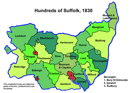
The hundred is about twelve miles (19 km) in length and six miles (10 km) wide. It is bounded on the west by the borough of Bury St Edmunds and Thingoe Hundred, on the north and east by Blackbourn and Stow Hundreds, and on the south by Cosford and Babergh Hundreds. It is a fertile district with undulating terrain and watered by streams which rise within its limits and feeding the rivers Thet, Gipping, Lark and Brett.[1]
It is in the Deanery of Thedwestry, the Archdeaconry of Sudbury, the Diocese of Ely and Liberty of St Edmund. It contains no town of any size, but Bury and Ixworth are on its borders.
Listed as Theivardestreu in the Domesday Book, the name derives from "Theodward's tree", presumably a notable tree situated on the area's boundary.[2]
Parishes
Thedwastre was made up of 24 parishes:[1][3]
| Parish | Area (acres) |
|---|---|
| Ampton | 870 |
| Beyton | 626 |
| Bradfield Combust | 800 |
| Bradfield St Clare | 1428 |
| Bradfield St George | 2000 |
| Drinkstone | 2170 |
| Felsham | 1605 |
| Fornham St Genevieve | 700 |
| Fornham St Martin | 1200 |
| Gedding | 502 |
| Great Barton | 3500 |
| Great Welnetham | 1409 |
| Hessett | 1568 |
| Little Welnetham | 570 |
| Livermere Magna | 1580 |
| Pakenham | 3696 |
| Rattlesden | 3200 |
| Rougham | 3846 |
| Rushbrooke | 1066 |
| Stanningfield | 1431 |
| Thurston | 2400 |
| Timworth | 1220 |
| Tostock | 975 |
| Woolpit | 2000 |
References
- 1 2 William White (1844). History, gazetteer, and directory of Suffolk. p. 301.
- ↑ Walter Skeat (1913). The Place-names of Suffolk.
- ↑ F. A. Youngs Jr., Guide to the Administrative Units of England, Vol.1: Southern England, London, 1979
See also
Coordinates: 52°14′N 0°45′E / 52.23°N 0.75°E