Blackbourn Hundred
Blackbourn was a hundred of Suffolk, consisting of 66,272 acres (26,819 ha).
Blackbourn hundred was situated in the north-west of Suffolk. Its northern boundary is the Little Ouse forming the border with Norfolk, and the River Lark forms part of its western boundary.
The hundred appears in the Domesday Book as Blachruna and Blackebrune meaning "black bourn", where a bourn is a stream. The stream in question is that which flows north through Ixworth, Bardwell, and Fakenham Magna to the Little Ouse at Euston and is still known as the Black Bourn.[1]
Parishes
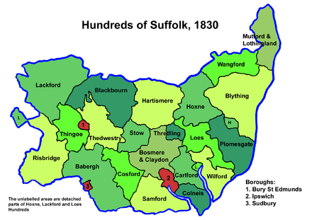
Suffolk hundreds
Blackbourn Hundred consisted of the following 34 parishes:[2]
| Parish | Area (acres) |
|---|---|
| Badwell Ash | 1860 |
| Bardwell | 3142 |
| Barnham | 5184 |
| Barningham | 1555 |
| Coney Weston | 1321 |
| Culford | 2490 |
| Elmswell | 2021 |
| Euston | 3780 |
| Fakenham Magna | 2155 |
| Great Ashfield | 2030 |
| Hepworth | 1640 |
| Hinderclay | 1400 |
| Honington | 1204 |
| Hopton | 1322 |
| Hunston | 1120 |
| Ingham | 1809 |
| Ixworth | 2213 |
| Ixworth Thorpe | 1000 |
| Knettishall | 1025 |
| Langham | 1270 |
| Little Livermere | 1433 |
| Market Weston | 1090 |
| Norton | 2450 |
| Rickinghall | 1966 |
| Rushford (part) | 1000 |
| Sapiston | 1155 |
| Stanton, Suffolk | 3254 |
| Stowlangtoft | 1358 |
| Thelnetham | 1721 |
| Troston | 1770 |
| Walsham-le-Willows | 2760 |
| Wattisfield | 1600 |
| West Stow | 3050 |
| Wordwell | 2120 |
References
Coordinates: 52°00′N 1°07′E / 52.0°N 1.11°E
This article is issued from Wikipedia - version of the 1/28/2016. The text is available under the Creative Commons Attribution/Share Alike but additional terms may apply for the media files.