Bosmere-and-Claydon Hundred
Bosmere and Claydon was a hundred of Suffolk, consisting of 31,850 acres (128.9 km2).[1]
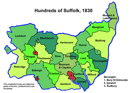
The hundred is a fertile and picturesque district varying from 8 to about 12 miles (19 km) in length and breadth. It is bounded on the south by the Borough of Ipswich and Samford Hundred, on the west by Cosford and Stow Hundreds on the north by Hartismere and Thredling Hundreds and on the east by Carlford Hundred. It falls in the Deaneries of Bosmere and Claydon in the Archdeaconry of Suffolk and Diocese of Norwich.
Its clay soil has long been associated with agriculture, and is suited to grain production. It is crossed by the River Gipping which becomes the River Orwell at Ipswich on becoming an estuary. Its main settlement is the town of Needham Market.
The hundred's name is taken from the parish of Claydon which falls within its bounds, and Bosmere, originally "Bosa's mere", a small lake near Needham Market in the grounds of Bosmere Hall.[2]
Parishes
Bosmere and Claydon Hundred consisted of the following 33 parishes:[1][3]
| Parish | Area (acres) |
|---|---|
| Akenham | 1060 |
| Ashbocking | 1383 |
| Badley | 1050 |
| Barham | 1800 |
| Battisford | 1542 |
| Baylham | 1332 |
| Bramford | 3247 |
| Claydon | 951 |
| Coddenham | 2719 |
| Creeting All Saints | 1286 |
| Creeting St Mary | 1441 |
| Creeting St Olave | 388 |
| Crowfield | 1700 |
| Darmsden | 790 |
| Flowton | 495 |
| Gosbeck | 1530 |
| Great Blakenham | 842 |
| Great Bricett | 916 |
| Helmingham | 2438 |
| Hemingstone | 1444 |
| Henley | 1233 |
| Little Blakenham | 1046 |
| Mickfield | 1300 |
| Needham Market | 3164 |
| Nettlestead | 1029 |
| Offton | 1530 |
| Ringshall | 2116 |
| Somersham | 1027 |
| Stonham Aspal | 2399 |
| Stonham Earl | 2521 |
| Stonham Parva | 1173 |
| Swilland | 951 |
| Willisham | 1030 |
References
- 1 2 William White (1844). History, gazetteer, and directory of Suffolk. p. 221.
- ↑ Walter Skeat (1913). The Place-names of Suffolk.
- ↑ 1841 Census
Coordinates: 52°09′N 1°06′E / 52.15°N 1.1°E