Stonelick Township, Clermont County, Ohio
| Stonelick Township, Clermont County, Ohio | |
|---|---|
| Township | |
|
| |
 Location of Stonelick Township in Clermont County | |
| Coordinates: 39°8′18″N 84°9′5″W / 39.13833°N 84.15139°WCoordinates: 39°8′18″N 84°9′5″W / 39.13833°N 84.15139°W | |
| Country | United States |
| State | Ohio |
| County | Clermont |
| Area | |
| • Total | 29.7 sq mi (76.8 km2) |
| • Land | 29.5 sq mi (76.4 km2) |
| • Water | 0.2 sq mi (0.4 km2) |
| Elevation[1] | 791 ft (241 m) |
| Population (2010) | |
| • Total | 5,890 |
| • Density | 200/sq mi (77.1/km2) |
| Time zone | Eastern (EST) (UTC-5) |
| • Summer (DST) | EDT (UTC-4) |
| ZIP code | 45103 |
| Area code(s) | 513 |
| FIPS code | 39-74825[2] |
| GNIS feature ID | 1085870[1] |
| Website |
stonelicktwp-oh |
Stonelick Township is one of the fourteen townships of Clermont County, Ohio, United States. The 2010 census reported 5,890 people living in the township,[3] 5,096 of whom lived in the unincorporated portions of the township.
Geography
Located in the northern part of the county, it borders the following townships:
- Goshen Township - north
- Wayne Township - northeast
- Jackson Township - east
- Batavia Township - south
- Union Township - southwest
- Miami Township - west
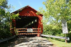
The village of Owensville is located in southern Stonelick Township.
Name and history
Stonelick Township was organized in 1812.[4] It is the only Stonelick Township statewide.[5]
Government
The township is governed by a three-member board of trustees, who are elected in November of odd-numbered years to a four-year term beginning on the following January 1. Two are elected in the year after the presidential election and one is elected in the year before it. There is also an elected township fiscal officer,[6] who serves a four-year term beginning on April 1 of the year after the election, which is held in November of the year before the presidential election. Vacancies in the fiscal officership or on the board of trustees are filled by the remaining trustees.
References
- 1 2 "US Board on Geographic Names". United States Geological Survey. 2007-10-25. Retrieved 2008-01-31.
- ↑ "American FactFinder". United States Census Bureau. Retrieved 2008-01-31.
- ↑ "Geographic Identifiers: 2010 Demographic Profile Data (G001): Stonelick township, Clermont County, Ohio". U.S. Census Bureau, American Factfinder. Retrieved January 16, 2015.
- ↑ Everts, Louis H. (1880). History of Clermont County, Ohio, with Illustrations and Biographical Sketches of Its Prominent Men and Pioneers. Philadelphia: J.B. Lippincott & Co. p. 527.
- ↑ "Detailed map of Ohio" (PDF). United States Census Bureau. 2000. Retrieved 2007-02-16.
- ↑ §503.24, §505.01, and §507.01 of the Ohio Revised Code. Accessed 4/30/2009.
External links
Municipalities and communities of Clermont County, Ohio, United States | ||
|---|---|---|
| Cities | 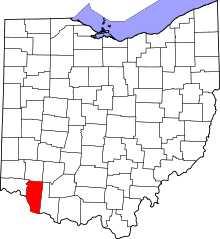 | |
| Villages | ||
| Townships | ||
| CDPs | ||
| Unincorporated communities |
| |
| Ghost towns | ||
| Footnotes | ‡This populated place also has portions in an adjacent county or counties | |