Springfield, New York
| Springfield, New York | |
|---|---|
| Town | |
 Springfield, Otsego County, New York | |
| Coordinates: 42°50′10″N 74°51′13″W / 42.83611°N 74.85361°W | |
| Country | United States |
| State | New York |
| County | Otsego |
| Settled | 1762 |
| Established | 1797 |
| Area | |
| • Total | 45.5 sq mi (117.7 km2) |
| • Land | 43.0 sq mi (111.3 km2) |
| • Water | 2.5 sq mi (6.4 km2) 5.46% |
| Elevation | 1,322 ft (403 m) |
| Population (2010) | |
| • Total | 1,358 |
| • Density | 30/sq mi (12/km2) |
| Time zone | Eastern (EST) (UTC-5) |
| • Summer (DST) | EDT (UTC-4) |
| ZIP code | 13333 |
| Area code(s) | 607 |
| FIPS code | 36-70310 |
| GNIS feature ID | 0979514 |
Springfield is a town in Otsego County, New York, USA. The population was 1,358 at the 2010 census.
The Town of Springfield is located at the northern county line of Otsego County and is approximately 50 mi (80 km) west of Schenectady.
History
Several families settled near Otsego Lake around 1762, but little further development occurred until after the American Revolution. In 1778, Joseph Brant, native leader, led an expedition that burned the town and took captives.
The Town of Springfield was formed from part of the Town of Cherry Valley in 1797. Growing hops was a major agricultural pursuit.
Notable residents
- Elisha Hall, inventor of a type of threshing machine.
- George Hyde Clarke, grandson to the Acting Governor of New York from 1736-1743 (under British rule)
- Arthur L. Ryerson, steel industrialist, who died on the Titantic maintained a summer home for his family in Springfield Center known as Ringwood
- Henry Lansing Wardwell, New York City financier, maintained a summer estate and farm in Springfield Center known as Pinehurst. Still owned by descendents today.
Geography
According to the United States Census Bureau, the town has a total area of 45.5 square miles (118 km2), of which, 43.0 square miles (111 km2) of it is land and 2.5 square miles (6.5 km2) of it (5.46%) is water.
The town encloses the northern end of Otsego Lake. Hayden Creek flows southward from Summit Lake into the northern end of the Otsego Lake. Because Summit Lake is located on a divide, part of its flow exits from the northern end of the lake through Cedar Swamp. The "Chyle," is the name of a sinkhole at the north end of Summit Lake. Shadow Brook enters Otsego Lake at Hyde Bay.
New York State Route 80, a north-south highway, intersects US Route 20, an east-west highway, north of Springfield Center.
The north town line is the county line of Herkimer County and a small section of Montgomery County.
Demographics
| Historical population | |||
|---|---|---|---|
| Census | Pop. | %± | |
| 1820 | 2,065 | — | |
| 1830 | 2,816 | 36.4% | |
| 1840 | 2,382 | −15.4% | |
| 1850 | 2,322 | −2.5% | |
| 1860 | 2,390 | 2.9% | |
| 1870 | 2,022 | −15.4% | |
| 1880 | 2,616 | 29.4% | |
| 1890 | 1,726 | −34.0% | |
| 1900 | 1,762 | 2.1% | |
| 1910 | 1,468 | −16.7% | |
| 1920 | 1,287 | −12.3% | |
| 1930 | 1,305 | 1.4% | |
| 1940 | 1,135 | −13.0% | |
| 1950 | 1,184 | 4.3% | |
| 1960 | 1,121 | −5.3% | |
| 1970 | 1,136 | 1.3% | |
| 1980 | 1,239 | 9.1% | |
| 1990 | 1,267 | 2.3% | |
| 2000 | 1,350 | 6.6% | |
| 2010 | 1,358 | 0.6% | |
| Est. 2014 | 1,328 | [1] | −2.2% |
As of the census[3] of 2000, there were 1,350 people, 521 households, and 375 families residing in the town. The population density was 31.4 people per square mile (12.1/km²). There were 712 housing units at an average density of 16.6 per square mile (6.4/km²). The racial makeup of the town was 98.59% White, 0.15% African American, 0.07% Native American, 0.22% Asian, 0.15% from other races, and 0.81% from two or more races. Hispanic or Latino of any race were 1.19% of the population.
There were 521 households out of which 32.4% had children under the age of 18 living with them, 60.1% were married couples living together, 6.5% had a female householder with no husband present, and 28.0% were non-families. 22.6% of all households were made up of individuals and 12.7% had someone living alone who was 65 years of age or older. The average household size was 2.59 and the average family size was 3.04.
In the town the population was spread out with 26.2% under the age of 18, 5.3% from 18 to 24, 25.3% from 25 to 44, 25.7% from 45 to 64, and 17.4% who were 65 years of age or older. The median age was 42 years. For every 100 females there were 98.8 males. For every 100 females age 18 and over, there were 99.6 males.
The median income for a household in the town was $33,854, and the median income for a family was $38,490. Males had a median income of $25,625 versus $23,611 for females. The per capita income for the town was $16,513. About 5.6% of families and 8.5% of the population were below the poverty line, including 10.8% of those under age 18 and 5.4% of those age 65 or over.
Communities and locations in Springfield
- Allen Lake – a small lake near the west town line.
- Clarke Point – a headland of Otsego Lake north of Hyde Bay.
- East Springfield – A hamlet east of Middle Village on US-20 at the junction of County Route 31. The East Springfield Union School and Hyde Hall Covered Bridge are listed on the National Register of Historic Places.[4]
- Glimmerglass State Park – A state park partly in the town at the eastern shore of Otsego Lake.
- Hyde Bay – A bay of Otsego Lake, partly in the town.
- Middle Village – A hamlet east of Springfield village on US-20.
- Mt. Wellington – a notable hill north of Otsego Lake.
- Shipman Pond – a pond north of Springfield Center.
- Springfield – The hamlet of Springfield is located on US Route 20.
- Springfield Center – A hamlet on NY-80, at County Route 29A, north of Otsego Lake.
- Springfield Four Corners – A location northwest of Springfield village, located on NY-80.
- Summit Lake – A small lake north of Otsego Lake.
References
- ↑ "Annual Estimates of the Resident Population for Incorporated Places: April 1, 2010 to July 1, 2014". Retrieved June 4, 2015.
- ↑ "Census of Population and Housing". Census.gov. Retrieved June 4, 2015.
- ↑ "American FactFinder". United States Census Bureau. Retrieved 2008-01-31.
- ↑ National Park Service (2009-03-13). "National Register Information System". National Register of Historic Places. National Park Service.
External links
Municipalities and communities of Otsego County, New York, United States | ||
|---|---|---|
| City | 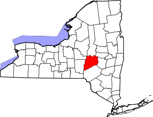 | |
| Towns | ||
| Villages | ||
| CDPs | ||
| Other hamlets | ||
| Footnotes | ‡This populated place also has portions in an adjacent county or counties | |
Coordinates: 42°50′10″N 74°51′13″W / 42.83611°N 74.85361°W