Roseboom, New York
| Roseboom, New York | |
|---|---|
| Town | |
 Roseboom,Otsego County, New York | |
| Coordinates: 42°42′40″N 74°43′36″W / 42.71111°N 74.72667°W | |
| Country | United States |
| State | New York |
| County | Otsego |
| Area | |
| • Total | 33.1 sq mi (85.6 km2) |
| • Land | 33.0 sq mi (85.5 km2) |
| • Water | 0.1 sq mi (0.1 km2) |
| Elevation | 1,453 ft (443 m) |
| Population (2010) | |
| • Total | 711 |
| • Density | 21/sq mi (8.3/km2) |
| Time zone | Eastern (EST) (UTC-5) |
| • Summer (DST) | EDT (UTC-4) |
| ZIP code | 13450 |
| Area code(s) | 607 |
| FIPS code | 36-63638 |
| GNIS feature ID | 0979434 |
Roseboom is a town in Otsego County, New York, United States. The population was 711 at the 2010 census. The town name is that of an early landowners and settlers Abram and John Roseboom.
The Town of Roseboom is at the eastern county line.
History
The town was not settled until after the American Revolution.
The town was created from part of the Town of Cherry Valley in 1854.
Geography
According to the United States Census Bureau, the town has a total area of 33.1 square miles (86 km2), of which, 33.0 square miles (85 km2) of it is land and 0.1 square miles (0.26 km2) of it (0.18%) is water.
New York State Route 165 intersects New York State Route 166 near the west town line at Roseboom village.
Cherry Valley Creek flows southward near the west town line, receiving the inflow of Pleasant Brook and Snyder Creek.
Demographics
| Historical population | |||
|---|---|---|---|
| Census | Pop. | %± | |
| 1860 | 1,870 | — | |
| 1870 | 1,589 | −15.0% | |
| 1880 | 1,515 | −4.7% | |
| 1890 | 1,190 | −21.5% | |
| 1900 | 1,031 | −13.4% | |
| 1910 | 885 | −14.2% | |
| 1920 | 773 | −12.7% | |
| 1930 | 633 | −18.1% | |
| 1940 | 534 | −15.6% | |
| 1950 | 570 | 6.7% | |
| 1960 | 518 | −9.1% | |
| 1970 | 483 | −6.8% | |
| 1980 | 630 | 30.4% | |
| 1990 | 668 | 6.0% | |
| 2000 | 684 | 2.4% | |
| 2010 | 711 | 3.9% | |
| Est. 2014 | 696 | [1] | −2.1% |
As of the census[3] of 2000, there were 684 people, 267 households, and 191 families residing in the town. The population density was 20.7 people per square mile (8.0/km²). There were 416 housing units at an average density of 12.6 per square mile (4.9/km²). The racial makeup of the town was 98.39% White, 0.15% African American, 0.88% Asian, 0.15% from other races, and 0.44% from two or more races. Hispanic or Latino of any race were 0.73% of the population.
There were 267 households out of which 33.3% had children under the age of 18 living with them, 55.1% were married couples living together, 9.4% had a female householder with no husband present, and 28.1% were non-families. 21.0% of all households were made up of individuals and 8.6% had someone living alone who was 65 years of age or older. The average household size was 2.56 and the average family size was 2.98.
In the town the population was spread out with 24.4% under the age of 18, 7.5% from 18 to 24, 27.8% from 25 to 44, 27.6% from 45 to 64, and 12.7% who were 65 years of age or older. The median age was 39 years. For every 100 females there were 106.6 males. For every 100 females age 18 and over, there were 106.8 males.
The median income for a household in the town was $37,841, and the median income for a family was $43,438. Males had a median income of $24,205 versus $19,940 for females. The per capita income for the town was $19,977. About 7.4% of families and 10.6% of the population were below the poverty line, including 19.4% of those under age 18 and 2.7% of those age 65 or over.
Communities and locations in Roseboom
- Belvedere Lake – A small lake east of Roseboom village.
- Butlers Corners – A location southwest of South Valley hamlet at the junction of County Roads 34 and 39.
- Center Valley – A hamlet on County Route 50 at the town line in the northeast corner of Roseboom.
- Honey Hill – An elevation north of South Valley.
- Lowell's Corners – A former location in the eastern part of Roseboom.
- Pleasant Brook – (1) A hamlet in the eastern part of Roseboom on NY-165, (2) a stream flowing westward past the hamlet.
- Roseboom (earlier "Lodi") – A hamlet near the west town line, located at the junction of routes NY-165 and NY-166 by Cherry Valley Creek. The Roseboom Historic District was listed on the National Register of Historic Places in 1998.[4]
- South Valley – A hamlet located in the south half of Roseboon on NY-165. The Women's Community Club of South Valley was listed on the National Register of Historic Places in 1999.[4]
- Weber Corners – A location at the east town line on NY-165.
- Winnie Hollow – A valley in the north part of the town.
References
- ↑ "Annual Estimates of the Resident Population for Incorporated Places: April 1, 2010 to July 1, 2014". Retrieved June 4, 2015.
- ↑ "Census of Population and Housing". Census.gov. Retrieved June 4, 2015.
- ↑ "American FactFinder". United States Census Bureau. Retrieved 2008-01-31.
- 1 2 National Park Service (2009-03-13). "National Register Information System". National Register of Historic Places. National Park Service.
Municipalities and communities of Otsego County, New York, United States | ||
|---|---|---|
| City | 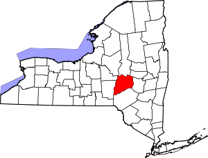 | |
| Towns | ||
| Villages | ||
| CDPs | ||
| Other hamlets | ||
| Footnotes | ‡This populated place also has portions in an adjacent county or counties | |
Coordinates: 42°44′30″N 74°46′36″W / 42.74167°N 74.77667°W