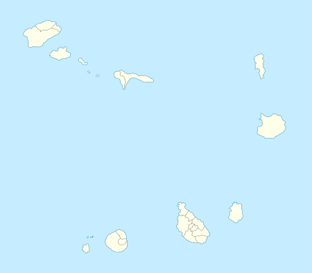
Santo Antão, Cape Verde
| Native name: <span class="nickname" ">Sontonton, Santanton or Sintanton Nickname: Ilha das montanhas (island of the mountains) | |
|---|---|
 | |
 Santo Antão | |
| Geography | |
| Location | Atlantic Ocean |
| Coordinates | 17°04′12″N 25°10′16″W / 17.070°N 25.171°W |
| Area | 779 km2 (301 sq mi) |
| Length | 40 km (25 mi) |
| Width | 20 km (12 mi) |
| Highest elevation | 1,979 m (6,493 ft) |
| Highest point | Topo da Coroa |
| Administration | |
|
Cape Verde | |
| Concelhos (Municipalities) | Paul, Porto Novo, Ribeira Grande |
| Largest settlement | Porto Novo |
| Demographics | |
| Population | 44,104 [1] (2010) |
| Pop. density | 56.6 /km2 (146.6 /sq mi) |
Santo Antão (Portuguese for "Saint Anthony"), or Sontonton in Cape Verdean Creole, is the westernmost and largest of the Barlavento islands of Cape Verde. The nearest main island is São Vicente to the southeast, separated by a channel named Canal de São Vicente. It is the westernmost large island in Cape Verde and the continent of Africa, and the second largest in Cape Verde.
Geography
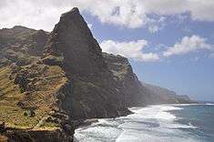
The island is entirely made up of volcanic material. The tallest mountain is Topo de Coroa, reaching a height of 1,979 m. The second tallest is Pico da Cruz at 1,585 m. The island is divided into north and south by a mountain range long considered impenetrable but now are crossed by two paved roads, one with mountain curves, another one opened in 2009 runs in the easternmost predominantly next to the sea. The island’s main town is Ponta do Sol on the north coast, home to the closed Agostinho Neto Airport, while its ferry port is Porto Novo on the south coast. A part of the island in the southeast has an arid climate, while the northwest receives relatively normal precipitation. Its valleys are suffering heavy erosion.
Water bodies
Canal de São Vicente lies to the southeast of Porto Novo and separates with the island of São Vicente.
Bathing beaches and fishing areas are found in near Tarrafal de Monte Trigo. During the rainy season, some creek beds across the island are temporarily filled with water.
Streams
- Ribeira de Alto Mira
- Ribeira do António
- Ribeira Brava
- Ribeira da Cruz
- Ribeira Grande
- Ribeira da Janela
- Ribeira das Bras, near Ribeira das Bras
- Ribeira do Passo, near Passo
- Ribeira do Paul
- Ribeira das Pombas
- Ribeira das Patas
- Ribeira da Tarrafal
- Ribeira da Torre
Mountains and volcanoes
The island is considered one of the most mountainous of Cape Verde. Its mountains are composed of basalt. Many of its volcanoes are young, especially its calderas. Since 1999, vulcanologists have observed continuous rising of the water temperature of the sea in the area of Ponta do Sol which may indicate the risk of a new eruption in the area.
Peaks
- Topo da Coroa (1,979 m) - highest on the island, located in the southwest
- Monte Tomé (1,863 m) - located in the west
- Gudo de Cavaleiro (1,810 m) - located in the southwest
- Pico da Cruz (1,584 m) - located in the middle
- Pau Seco (around 950 m) - located in the eastern part
Climate
Being basically made of several stratovolcanoes and so extremely mountainous this island has quite diverse climate and many various microclimates due to its deep ravines. Santo Antão island has moderately dry tropical climate (As according to Köppen–Geiger climate classification system) along the coast and semi-arid mild tropical climate Bsh with very balanced temperatures year round higher on the slopes (~ 800 metres ASL) to cool highland subtropical steppe climate BskL above 1,000 metres above ASL. The average annual temperature on the coast is about 23 °C (73 °F), decreasing to some 11 to 15 °C (52–59 °F) on the highest grounds. There can be remarkably cool weather in the interior with warmer wet season starting in July and ending in December–January with colder dry season starting in December–January and ending in June. The major climate risk, similarly to other Cape Verdean islands, yet much less pronounced in the higher altitudes due to better ability in gaining moisture from clouds, is drought.
| Climate data for Espongeiro, central highland of the island, 1250-1400 metres ASL | |||||||||||||
|---|---|---|---|---|---|---|---|---|---|---|---|---|---|
| Month | Jan | Feb | Mar | Apr | May | Jun | Jul | Aug | Sep | Oct | Nov | Dec | Year |
| Average high °C (°F) | 15.5 (59.9) |
15.3 (59.5) |
15.9 (60.6) |
16.3 (61.3) |
17.2 (63) |
17.9 (64.2) |
19.0 (66.2) |
20.0 (68) |
20.3 (68.5) |
19.8 (67.6) |
18.5 (65.3) |
16.5 (61.7) |
17.7 (63.9) |
| Daily mean °C (°F) | 13.2 (55.8) |
12.8 (55) |
13.2 (55.8) |
13.6 (56.5) |
14.5 (58.1) |
15.3 (59.5) |
16.3 (61.3) |
17.3 (63.1) |
17.7 (63.9) |
17.4 (63.3) |
16.0 (60.8) |
14.4 (57.9) |
15.1 (59.2) |
| Average low °C (°F) | 10.9 (51.6) |
10.4 (50.7) |
10.6 (51.1) |
10.9 (51.6) |
11.9 (53.4) |
12.8 (55) |
13.7 (56.7) |
14.7 (58.5) |
15.1 (59.2) |
15.0 (59) |
13.6 (56.5) |
12.3 (54.1) |
12.7 (54.9) |
| Average rainfall mm (inches) | 24 (0.94) |
4 (0.16) |
4 (0.16) |
1 (0.04) |
0 (0) |
0 (0) |
20 (0.79) |
82 (3.23) |
105 (4.13) |
55 (2.17) |
31 (1.22) |
25 (0.98) |
351 (13.82) |
| Source: Climate-Data.ORG | |||||||||||||
| Climate data for Sinagoga, far northeastern part of the island, 20-40 metres ASL | |||||||||||||
|---|---|---|---|---|---|---|---|---|---|---|---|---|---|
| Month | Jan | Feb | Mar | Apr | May | Jun | Jul | Aug | Sep | Oct | Nov | Dec | Year |
| Average high °C (°F) | 23.3 (73.9) |
23.1 (73.6) |
23.6 (74.5) |
24.1 (75.4) |
24.9 (76.8) |
25.6 (78.1) |
26.4 (79.5) |
27.4 (81.3) |
27.6 (81.7) |
27.4 (81.3) |
26.4 (79.5) |
24.3 (75.7) |
25.3 (77.5) |
| Daily mean °C (°F) | 21.4 (70.5) |
21.2 (70.2) |
21.5 (70.7) |
21.9 (71.4) |
22.7 (72.9) |
23.6 (74.5) |
24.3 (75.7) |
25.4 (77.7) |
25.8 (78.4) |
25.5 (77.9) |
24.4 (75.9) |
22.6 (72.7) |
23.4 (74.1) |
| Average low °C (°F) | 19.6 (67.3) |
19.3 (66.7) |
19.5 (67.1) |
19.8 (67.6) |
20.6 (69.1) |
21.7 (71.1) |
22.3 (72.1) |
23.5 (74.3) |
24.1 (75.4) |
23.7 (74.7) |
22.5 (72.5) |
21.0 (69.8) |
21.5 (70.7) |
| Average rainfall mm (inches) | 14 (0.55) |
5 (0.2) |
1 (0.04) |
0 (0) |
0 (0) |
0 (0) |
11 (0.43) |
44 (1.73) |
128 (5.04) |
44 (1.73) |
26 (1.02) |
18 (0.71) |
291 (11.45) |
| Source: Climate-Data.ORG | |||||||||||||
| Climate data for Porto Novo, centre-south of the island, 10-60 metres ASL | |||||||||||||
|---|---|---|---|---|---|---|---|---|---|---|---|---|---|
| Month | Jan | Feb | Mar | Apr | May | Jun | Jul | Aug | Sep | Oct | Nov | Dec | Year |
| Average high °C (°F) | 24.0 (75.2) |
23.4 (74.1) |
24.1 (75.4) |
24.6 (76.3) |
25.3 (77.5) |
26.2 (79.2) |
27.3 (81.1) |
27.9 (82.2) |
27.6 (81.7) |
27.5 (81.5) |
27.0 (80.6) |
25.2 (77.4) |
25.8 (78.4) |
| Daily mean °C (°F) | 22.0 (71.6) |
21.6 (70.9) |
22.0 (71.6) |
22.3 (72.1) |
23.0 (73.4) |
24.1 (75.4) |
25.0 (77) |
25.9 (78.6) |
26.0 (78.8) |
25.8 (78.4) |
25.0 (77) |
23.4 (74.1) |
23.8 (74.8) |
| Average low °C (°F) | 20.1 (68.2) |
19.8 (67.6) |
19.9 (67.8) |
20.1 (68.2) |
20.8 (69.4) |
22.1 (71.8) |
22.7 (72.9) |
23.9 (75) |
24.4 (75.9) |
24.2 (75.6) |
23.0 (73.4) |
21.6 (70.9) |
21.9 (71.4) |
| Average rainfall mm (inches) | 7 (0.28) |
2 (0.08) |
1 (0.04) |
0 (0) |
0 (0) |
0 (0) |
4 (0.16) |
28 (1.1) |
86 (3.39) |
31 (1.22) |
17 (0.67) |
15 (0.59) |
191 (7.53) |
| Source: Climate-Data.ORG | |||||||||||||
History
The island was discovered on January 17, 1462 by Diogo Afonso before the island of São Vicente was discovered, but was not given its current name until around the 16th century. In the westernmost part, it marked the point where under the old Treaty of Tordesillas which was put on June 7, 1494 between Portugal and the Kingdom of Castile that determined the division of the areas of influences of the Iberian countries it marked the line of discovered and then undiscovered lands with an imaginary line located 370 leagues (1,770 km) west of the island. First inhabited in 1548, in the 17th century, people from the other islands of Santiago and Fogo along with people from northern Portugal arrived in today's Vila da Ribeira Grande in the northern part of the island. Later, wine and coffee became the most important exports on the island. As of 1832, the estimated population of Santo Antão was 24,000.[2] The highest population was reached in the 2000 census and it was 47,170 up from 35,976, the population had not largely grew.
Economy
Fishing and agriculture are the main industries on the island.
Agriculture
The island's agriculture products include sugar cane, yams, cassava, bananas, mangoes, and grain. The main product on the island is a kind of rum known as grogue. Mills continue to distill grogue in the Paul Valley.
Due to its mountainous nature, most of the island's plantations are done in terraces, obviating the use of machinery and requiring immense manual labor. Recently, some experiences using Drip irrigation have been taking place in order to mitigate the drought conditions.
The first sugar cane was exported from other Macaronesian Islands, sugar became the island's chief agricultural production from the mid 19th century.
The exportation of many of the island's agriculture products to other islands has been prohibited for nearly two decades because of the millipede (Spinotarsus caboverdus) blight, but the government has announced it is going to lift the quarantine.[3]
Tourism
Tourism is becoming one of the most dominant industries on the island. There has been some investment in Rural tourism infrastructures. Hiking, Trekking and Cultural tourism account for most of the touristic offer of this island.
Administrative divisions
The island is divided in three municipalities, which are subdivided into civil parishes:
- Paul
CV-PA - Porto Novo
CV-PN - Ribeira Grande
CV-RG
The island was a single municipality until 1990 (old ISO 3166-2 code: CV-SA) when it broke up into the three present-day municipalities.
Language
Other than Portuguese (official language), the majority of the population speaks Cape Verdean Creole.
- Estóra de Tipêde i Tilôbe ("Ti Pedro and Ti Lobo" traditional story) by Luís Romano de Madeira Melo
Persons
- Jorge Ferreira Chaves (1920–1982), Portuguese architect
- Domingos Lima Costa, violinist
- Gabriel Costa (Nho Kzick), violinist (f. 2005)
- Leão Lopes (b. 1948), writer, professor and entertainment director
- Gabriel Mariano, essayist, novelist and poet
- Luís Romano de Madeira Melo, composer
- Manuel de Novas, songwriter
- Roberto Duarte Silva (1837–1889), chemist
- Antoninho Travadinha, violinist
Sporting teams
The island features two island divisions, the North and the South Zones, they were divided in 1997 and fully in 2003 and features the championship, cup, super cup and opening island tournaments, Since late 2015, the single island cup and super cup competitions were established.
The football (soccer) clubs of the two zones are:
- Associação Académica do Porto Novo - North Zone
- Beira-Mar - South Zone
- GDRC Fiorentina - South Zone
- Os Foguetões - North Zone
- Inter - South Zone
- Irmãos Unidos - North Zone
- Janela - North Zone
- Lagedos - South Zone
- Marítimo (Porto Novo) - South Zone
- Paulense Desportivo Clube - North Zone
- Povoação - former club
- Rosariense - North Zone
- Sanjoanense - South Zone
- Santo André - South Zone
- São Pedro Apostolo - North Zone
- Solpontense - North Zone
- Sporting Clube do Porto Novo - South Zone
- Tarrafal de Monte Trigo - South Zone
External links
| Wikimedia Commons has media related to Santo Antão (Cape Verde). |
- University of Massachusetts - information and images from Santo Antão
- caboverde.com
References
- ↑ Portal do Instituto Nacional de Estatística: INE - CENSO 2010
- ↑ Roberts, Edmund (1837). Embassy to the Eastern Courts of Cochin-China, Siam, and Muscat. New York: Harper & Brothers. pp. 14–15.
- ↑ Agriculture producers from Santo Antão can now export to Sal and Boa Vista, A Semana online, 9 January 2008
| Island groups | ||
|---|---|---|
| Islands | ||
| Islets | ||
Coordinates: 17°04′12″N 25°10′16″W / 17.070°N 25.171°W