Ribeira da Janela, Cape Verde
| Ribeira da Janela | |
|---|---|
 | |
| Country | Cape Verde |
| Basin | |
| Main source |
near Cova Crater Santo Antão |
| River mouth |
Atlantic Ocean 17°07′19″N 24°59′38″W / 17.122°N 24.994°WCoordinates: 17°07′19″N 24°59′38″W / 17.122°N 24.994°W |
| Physical characteristics | |
| Length | 6 km (3.7 mi) |
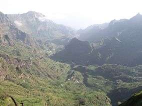
Ribeira da Janela is a stream that flows in the eastern part of the island of Santo Antão in Cape Verde, its length is 6 km. The stream flows from southwest to northeast. Its source is east of the Cova Crater near Tope Verde and it empties into the Atlantic Ocean in the settlement Janela, west of the village Pontinha. The entire valley belongs to Cova-Ribeira da Torre-Paul Natural Park.[1]
See also
References
External links
| Parish | 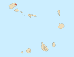 | |
|---|---|---|
| Communities and settlements | ||
| Geographical features |
| |
| Landmarks and points of Interests | ||
| Culture | ||
This article is issued from Wikipedia - version of the 11/30/2016. The text is available under the Creative Commons Attribution/Share Alike but additional terms may apply for the media files.