Tarrafal de Monte Trigo
| Tarrafal de Monte Trigo | |
|---|---|
 | |
 | |
| Coordinates: 16°57′32″N 25°18′36″W / 16.959°N 25.310°WCoordinates: 16°57′32″N 25°18′36″W / 16.959°N 25.310°W | |
| Country | Cape Verde |
| Island | Santo Antão |
| Municipality | Porto Novo |
| Civil parish | São João Baptista |
| Population (2010)[1] | |
| • Total | 841 |
Tarrafal de Monte Trigo is a settlement in the southwestern part of the island of Santo Antão, Cape Verde. It is situated on the coast, 27 km west of the island capital Porto Novo, the parish boundary with Santo André is around halfway to the north. The island is linked by a single dirt road connecting the east of the island, until 2000, the portion crossing the mountain was dirt, in 2002 the eastern stretch became paved, the paved road reached the summit area in 2007 and some 3 kilometers west as of 2016, the remainder remains unpaved and is one of the last roads in the country remain unpaved, a pathway connects with Monte Trigo to the north that takes 2h 30 min to reach. It also has a ferry service with Monte Trigo in the northwest of the island and its length is 40 minutes.
The valley consists of the agricultural groves, some farmlands and a some woods, much of the area are barren grasslands and the terrain consists of lava flows mainly dating back to the last eruption 200,000 years ago.
The Young Tarrafal Group is a rock formation made from the island's last eruption 200,000 years ago out of a plinian volcanic eruption. It consists of nephelite rocks.
Sporting clubs
- Tarrafal FC de Monte Trigo - the westernmost sporting club in the whole of Africa
See also
References
- ↑ "2010 Census results". Instituto Nacional de Estatística Cabo Verde (in Portuguese). 17 March 2014.
External links
Subdivisions of the island of Santo Antão | |||||||||||||||
|---|---|---|---|---|---|---|---|---|---|---|---|---|---|---|---|
| Paul |
|  | |||||||||||||
| Porto Novo | |||||||||||||||
| Ribeira Grande | |||||||||||||||
| Parishes | 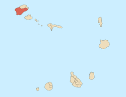 | |
|---|---|---|
| Communities and settlements | ||
| Geographical features |
| |
| Landmarks and points of Interests |
| |
| Culture |
| |