Sandstone, Minnesota
| Sandstone, Minnesota Asinikaaning | ||
|---|---|---|
| City | ||
| ||
 Location of the city of Sandstone within Pine County, Minnesota | ||
| Coordinates: 46°7′47″N 92°51′54″W / 46.12972°N 92.86500°W | ||
| Country | United States | |
| State | Minnesota | |
| County | Pine | |
| Area[1] | ||
| • Total | 5.43 sq mi (14.06 km2) | |
| • Land | 5.26 sq mi (13.62 km2) | |
| • Water | 0.17 sq mi (0.44 km2) | |
| Elevation | 1,089 ft (332 m) | |
| Population (2010)[2] | ||
| • Total | 2,849 | |
| • Estimate (2012[3]) | 2,770 | |
| • Density | 541.6/sq mi (209.1/km2) | |
| • Demonym | Sandstonian | |
| Time zone | Central (CST) (UTC-6) | |
| • Summer (DST) | CDT (UTC-5) | |
| ZIP code | 55072 | |
| Area code(s) | 320 | |
| FIPS code | 27-58396[4] | |
| GNIS feature ID | 0651181[5] | |
| Website | www.sandstone.govoffice.com | |
Sandstone is a city in Pine County, Minnesota, United States, along the Kettle River. The population was 2,849 at the 2010 census.[6]
Interstate 35 and Minnesota State Highways 18 and 23 are three of the main routes in the community.
Banning State Park is nearby.
History
Originally the Village of Fortuna was platted by W. A. Porter and incorporated on May 19, 1857. It was originally platted at the junction of the Point Douglas to Superior Military Road and Kettle River. Fortuna served as the county seat for Buchanan County, Minnesota. By 1887, it had 200 residents. Just north of Fortuna, the Village of Sandstone was platted in June 1887 and incorporated on September 28, 1887. On April 14, 1920, the villages of Fortuna and Sandstone merged and re-incorporated as the City of Sandstone.[7]
The city's name in the Ojibwe language is Asinikaaning, meaning "At the quarrying place" due to the sandstone quarry located at the edge of the city.
Geography
According to the United States Census Bureau, the city has a total area of 5.43 square miles (14.06 km2), of which 5.26 square miles (13.62 km2) is land and 0.17 square miles (0.44 km2) is water.[1]
Features
Sandstone is located on the Kettle River, known for its glacial kettles, and rapids well loved by kayakers and canoeists. The town was built-up around a large Sandstone quarry. Railroad conglomerate James J. Hill built many of the remaining sandstone structures in the town.
The city has Robinson Park, an historic and natural area that serves as the picnic area for the community, hosts ice climbing in the winter, preserving the Sandstone Quarry history and is an access point for the Kettle River.
The Sandstone Ice Festival sandstoneicefest.com celebrates the coming of winter and is held in the beginning of December each year. The event welcomes in the winter with ice climbing, winter camping and snow shoeing. In the spring local paddlers host the Kettle River Paddle Festival kettleriverpaddlefest.com, an event for canoeists and kayakers. A down river race and a whitewater rodeo attract paddlers from all over the mid-western United States.
The community is surrounded by Banning State Park, has a connection to the Munger Bicycle Trail and is home to the Audubon Center of the North Woods, a residential environmental education and conference facility that offers programs for schools, adults, colleges, and retreats.
In recent years, Sandstone has gained national recognition as the home of the Midwest Country Music Theatre. Performances from this traditional country and western music venue are seen regularly on the RFD-TV satellite network.
A Federal Correctional Institution rated for low-security federal inmates is located 2 miles outside of Sandstone.[8]
Demographics
| Historical population | |||
|---|---|---|---|
| Census | Pop. | %± | |
| 1890 | 517 | — | |
| 1900 | 1,187 | 129.6% | |
| 1910 | 1,818 | 53.2% | |
| 1920 | 1,200 | −34.0% | |
| 1930 | 1,083 | −9.7% | |
| 1940 | 1,559 | 44.0% | |
| 1950 | 1,097 | −29.6% | |
| 1960 | 1,552 | 41.5% | |
| 1970 | 1,641 | 5.7% | |
| 1980 | 1,594 | −2.9% | |
| 1990 | 2,057 | 29.0% | |
| 2000 | 1,549 | −24.7% | |
| 2010 | 2,849 | 83.9% | |
| Est. 2015 | 2,768 | [9] | −2.8% |
| U.S. Decennial Census | |||
2010 census
As of the census[2] of 2010, there were 2,849 people, 602 households, and 362 families residing in the city. The population density was 541.6 inhabitants per square mile (209.1/km2). There were 652 housing units at an average density of 124.0 per square mile (47.9/km2). The racial makeup of the city was 71.5% White, 15.5% African American, 5.7% Native American, 0.6% Asian, 0.1% Pacific Islander, 3.6% from other races, and 2.9% from two or more races. Hispanic or Latino of any race were 11.0% of the population.
There were 602 households of which 36.5% had children under the age of 18 living with them, 31.9% were married couples living together, 21.3% had a female householder with no husband present, 7.0% had a male householder with no wife present, and 39.9% were non-families. 33.2% of all households were made up of individuals and 17.8% had someone living alone who was 65 years of age or older. The average household size was 2.42 and the average family size was 2.94.
The median age in the city was 34.9 years. 14.6% of residents were under the age of 18; 9.2% were between the ages of 18 and 24; 46.1% were from 25 to 44; 20.2% were from 45 to 64; and 9.8% were 65 years of age or older. The gender makeup of the city was 71.0% male and 29.0% female.
2000 census
As of the census[4] of 2000, there were 1,549 people, 580 households, and 359 families residing in the city. The population density was 292.5 people per square mile (112.8/km²). There were 634 housing units at an average density of 119.7 per square mile (46.2/km²). The racial makeup of the city was 94.84% White, 0.39% African American, 3.55% Native American, 0.32% Asian, 0.06% Pacific Islander, 0.39% from other races, and 0.45% from two or more races. Hispanic or Latino of any race were 1.42% of the population.
There were 580 households out of which 30.3% had children under the age of 18 living with them, 44.5% were married couples living together, 13.4% had a female householder with no husband present, and 38.1% were non-families. 32.1% of all households were made up of individuals and 16.4% had someone living alone who was 65 years of age or older. The average household size was 2.41 and the average family size was 3.03.
In the city the population was spread out with 24.9% under the age of 18, 8.0% from 18 to 24, 25.7% from 25 to 44, 17.4% from 45 to 64, and 24.0% who were 65 years of age or older. The median age was 38 years. For every 100 females there were 79.1 males. For every 100 females age 18 and over, there were 73.6 males.
The median income for a household in the city was $40,265, and the median income for a family was $43,684. Males had a median income of $32,500 versus $21,181 for females. The per capita income for the city was $18,053. About 11.6% of families and 16.7% of the population were below the poverty line, including 24.4% of those under age 18 and 13.9% of those age 65 or over.
Notable people
- Doug Carlson (1939–2013), veterinarian and politician[10]
- Yonassan Gershom (b. 1947), rabbi and author, early proponent of the Jewish Renewal movement
- The KanDells, 1960s early garage rock band of cult status[11]
Tyler Gaede, Quarterback, led only East Central Eagles Football team to make it to the MSHSL state tournament.
Education
The area is served by East Central Schools.[12]
See also
VisitSandstoneMN official tourism website for Sandstone Minnesota
Notes
- 1 2 "US Gazetteer files 2010". United States Census Bureau. Retrieved 2012-11-13.
- 1 2 "American FactFinder". United States Census Bureau. Retrieved 2012-11-13.
- ↑ "Population Estimates". United States Census Bureau. Retrieved 2013-05-28.
- 1 2 "American FactFinder". United States Census Bureau. Retrieved 2008-01-31.
- ↑ "US Board on Geographic Names". United States Geological Survey. 2007-10-25. Retrieved 2008-01-31.
- ↑ "2010 Census Redistricting Data (Public Law 94-171) Summary File". American FactFinder. U.S. Census Bureau, 2010 Census. Retrieved 23 April 2011.
- ↑ Upham, Warren. (1920; repr. 1991)Minnesota Place Names St. Paul: Minnesota Historical Society Press.
- ↑ http://www.bop.gov/locations/institutions/sst/index.jsp
- ↑ "Annual Estimates of the Resident Population for Incorporated Places: April 1, 2010 to July 1, 2015". Retrieved July 2, 2016.
- ↑ Minnesota Legislators Past and Present-Douglas W. Carlson
- ↑ The Kan-Dells from Beyond the Beat Generation
- ↑ East Central Schools
External links
| Wikivoyage has a travel guide for Sandstone, Minnesota. |
- Visit Sandstone MN – www.visitsandstonemn.com
- Sandstone Ice Festival – www.sandstoneicefest.com
- Kettle River Paddle Festival – www.kettleriverpaddlefest.com
- Midwest Country Theater – www.midwestcountry.com
Municipalities and communities of Pine County, Minnesota, United States | ||
|---|---|---|
| Cities | 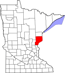 | |
| Townships | ||
| Unincorporated communities | ||
| Ghost towns | ||
| Indian reservation | ||
Coordinates: 46°07′52″N 92°52′03″W / 46.13111°N 92.86750°W