San Juan, Batangas
| San Juan | ||
|---|---|---|
| Municipality | ||
|
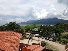
Gen. Luna Street, the town proper's main thoroughfare | ||
| ||
| Nickname(s): Bolbok | ||
| Motto: San Juan ang bayan ko, Mahal ko ito! | ||
 Map of Batangas showing the location of San Juan | ||
.svg.png) San Juan Location within the Philippines | ||
| Coordinates: 13°50′N 121°24′E / 13.83°N 121.4°ECoordinates: 13°50′N 121°24′E / 13.83°N 121.4°E | ||
| Country | Philippines | |
| Region | CALABARZON (Region IV-A) | |
| Province | Batangas | |
| District | 4th District | |
| Founded | December 12, 1848 | |
| Barangays | 42 | |
| Government[1] | ||
| • Mayor | Rodolfo H. Manalo (Liberal Party) | |
| Area[2] | ||
| • Total | 273.4 km2 (105.6 sq mi) | |
| Population (2015 census)[3] | ||
| • Total | 108,585 | |
| • Density | 400/km2 (1,000/sq mi) | |
| Time zone | PST (UTC+8) | |
| ZIP code | 4226 | |
| Dialing code | +63 (0)43 | |
| Income class | 1st class; partly urban | |
| Website |
www | |

San Juan is a first class municipality on the Philippines in the province of Batangas. It is 43 kilometres (27 mi) east of Batangas City, also the same distance south-west of Lucena City, the capital of Quezon Province, and 115 kilometres (71 mi) south of Manila. According to the 2015 census, it has a population of 108,585.[3]
Considered today as the second largest municipality (land area) in Batangas, San Juan is located at the easternmost part of Batangas province. North of San Juan is the neighboring town of Candelaria, Quezon, with Malaking River defining its geographical boundary. Tayabas Bay lies east and the hills on the eastern portion separate it from the towns of Lobo and Rosario.
Barangays
San Juan is politically subdivided into 42 barangays:[2]
| PSGC | Barangay | Population | ±% p.a. | ||
|---|---|---|---|---|---|
| 2015[3] | 2010[4] | ||||
| 041023001 | Abung | 2.0% | 2,119 | 1,947 | +1.62% |
| 041023002 | Balagbag | 2.3% | 2,539 | 2,147 | +3.24% |
| 041023003 | Barualte | 1.5% | 1,676 | 1,389 | +3.64% |
| 041023004 | Bataan | 1.8% | 1,911 | 1,786 | +1.30% |
| 041023005 | Buhay na Sapa | 4.7% | 5,123 | 3,751 | +6.11% |
| 041023006 | Bulsa | 2.0% | 2,160 | 1,543 | +6.61% |
| 041023007 | Calicanto | 1.8% | 1,957 | 1,908 | +0.48% |
| 041023008 | Calitcalit | 4.2% | 4,556 | 4,128 | +1.90% |
| 041023009 | Calubcub I | 2.0% | 2,206 | 1,794 | +4.01% |
| 041023010 | Calubcub II | 3.2% | 3,529 | 3,360 | +0.94% |
| 041023011 | Catmon | 1.3% | 1,418 | 1,282 | +1.94% |
| 041023012 | Coloconto | 0.7% | 758 | 702 | +1.47% |
| 041023013 | Escribano | 3.0% | 3,255 | 2,844 | +2.60% |
| 041023014 | Hugom | 1.5% | 1,578 | 1,301 | +3.74% |
| 041023015 | Imelda (Tubog) | 0.9% | 959 | 909 | +1.02% |
| 041023016 | Janaojanao | 1.4% | 1,511 | 1,466 | +0.58% |
| 041023017 | Laiya‑Ibabao | 4.1% | 4,504 | 3,580 | +4.47% |
| 041023018 | Laiya‑Aplaya | 5.5% | 6,005 | 5,572 | +1.44% |
| 041023019 | Libato | 3.8% | 4,107 | 3,997 | +0.52% |
| 041023020 | Lipahan | 4.0% | 4,380 | 3,814 | +2.67% |
| 041023021 | Mabalanoy | 3.5% | 3,834 | 3,155 | +3.78% |
| 041023022 | Nagsaulay | 2.4% | 2,604 | 2,404 | +1.53% |
| 041023023 | Maraykit | 3.3% | 3,574 | 3,060 | +3.00% |
| 041023024 | Muzon | 1.4% | 1,539 | 1,497 | +0.53% |
| 041023025 | Palahanan I | 0.8% | 841 | 713 | +3.19% |
| 041023026 | Palahanan II | 3.0% | 3,234 | 2,954 | +1.74% |
| 041023027 | Palingowak | 1.5% | 1,632 | 1,469 | +2.02% |
| 041023028 | Pinagbayanan | 1.4% | 1,508 | 1,173 | +4.90% |
| 041023029 | Poblacion | 3.0% | 3,281 | 3,111 | +1.02% |
| 041023030 | Poctol | 2.3% | 2,548 | 2,216 | +2.69% |
| 041023031 | Pulangbato | 2.5% | 2,767 | 2,391 | +2.82% |
| 041023032 | Putingbuhangin | 2.3% | 2,491 | 1,872 | +5.59% |
| 041023033 | Quipot | 3.1% | 3,328 | 2,517 | +5.46% |
| 041023034 | Sampiro | 2.9% | 3,151 | 2,690 | +3.06% |
| 041023035 | Sapangan | 2.7% | 2,940 | 2,435 | +3.65% |
| 041023036 | Sico I | 1.8% | 1,977 | 1,700 | +2.92% |
| 041023037 | Sico II | 1.0% | 1,100 | 934 | +3.16% |
| 041023038 | Subukin | 1.5% | 1,635 | 1,444 | +2.39% |
| 041023039 | Talahiban I | 2.1% | 2,244 | 2,055 | +1.69% |
| 041023040 | Talahiban II | 1.2% | 1,301 | 1,261 | +0.60% |
| 041023041 | Ticalan | 1.7% | 1,830 | 1,486 | +4.04% |
| 041023042 | Tipaz | 2.7% | 2,975 | 2,534 | +3.10% |
| Total | 108,585 | 94,291 | +2.72% | ||
Demographics
| Population census of San Juan | ||
|---|---|---|
| Year | Pop. | ±% p.a. |
| 1990 | 67,741 | — |
| 1995 | 71,913 | +1.13% |
| 2000 | 78,169 | +1.80% |
| 2007 | 87,276 | +1.53% |
| 2010 | 94,291 | +2.85% |
| 2015 | 108,585 | +2.72% |
| Source: Philippine Statistics Authority[3][4] | ||
The population of San Juan, Batangas, in the 2015 census was 108,585 people,[3] with a density of 400 inhabitants per square kilometre or 1,000 inhabitants per square mile.
Local government

Local officials were elected during the 2016 National and Local Elections and their term is set to expire on 2019.[1]
- Provincial Governor: Hermilando Mandanas
- Provincial Vice-Governor: Sofronio Ona II
- Congressman (4th District of Batangas): Lianda Bolilia
- Municipal Mayor: Rodolfo Manalo
- Vice-Mayor: Ildebrando Salud
- Sangguniang Bayan Members:
- Florencio M. De Chavez
- Meynardo E. Maalihan
- Wenceslao L. Llana III
- Alvin John O. Samonte
- Melchor C. Ayap
- Rodelio A. De Chavez
- Rowena M. Magadia
- Evelyn S. Baltazar
- ABC President: Wivin R. Llana
List of former municipal mayors
| Order | Name | Year in Office | Achievement |
|---|---|---|---|
| 1 | Don Esteban de Villa | 1900-1905; 1916-1919 | Built the town's public market |
| 2 | Don Gregorio de Villa | 1905-1906; 1913-1916 | Constructed the town's elementary school (Gabaldon) |
| 3 | Don Benedicto de Villa | 1906-1907 | Pioneered the town's sugar industry that brought prosperity to the town |
| 4 | Don Raymundo Balinos | 1907-1910 | Encouraged the education of the town's people |
| 4 | Don Florencio Perez | 1910-1913 | Built a public cemetery for the poor and the non-Catholics |
| 5 | Don Juan R. Quizon | 1919-1922; 1925-1928 | Constructed the municipal building and acquired the site for the town plaza |
| 6 | Don Nicolas Virrey | 1922-1925 | |
| 7 | Don Filemon Malabanan | 1928-1934 | Built the water reservoir and worked for the electrification of the town |
| 8 | Don Miguel Lopez | 1934-1942 | Instrumental in the building of San Juan East Central School |
| 9 | Hon. Guillermo de Villa | 1942-1945 | Maintained peaceful relationship with the Japanese government while working secretly with the guerillas |
| 10 | Hon. Vicente Castillo | 1945; 1946-1955 | Built the Lawaye River Dike, and organized the town's police force |
| 11 | Hon. Jose Garcia | 1956-1963 | Built the Sampiro-Quipot feeder road |
| 12 | Hon. Estelito Castillo | 1964-1967 | Repaired municipal building, implemented the minimum wage law, and managed to acquire fire trucks from the national government |
| 13 | Hon. Vicente Lecaroz | 1968-1986 |
Built feeder roads and bridges; responsible for the construction of additional school buildings; he also eradicated cattle-rustling |
| 14 | Hon. Abelardo de Villa | 1986-1998 | Electrification of barrios; built new feeder roads, new bridges and cemented road to Laiya. |
| 15 | Hon. Rodolfo H. Manalo | 1998-2007; 2010–present | Constructed barangay roads; beautification of San Juan; Scholarships for the San Juaneño students; Built the new town's public market |
| 16 | Hon. Danilo S. Mindanao | 2007-2010 |
Asphalting of roads; he envisioned the cityhood of San Juan |
Official seal

- Horse– The municipality is known for its horses and other farm animals like cows, pigs, and goats.
- Tuba Container- Locally known as "batang", a container where tuba is gathered from the coconut tree. It also refers to San Juan as "Lambanog Country".
- Fruits- Fruits such mangoes, citrus, atis and tamarind which are grown abundantly in the town.
- Roundels- Number of barangays (42) comprising the municipality.
Economy
San Juan is a first class municipality in the province of Batangas. According to the Local Government Performance Management System 2012 of the Department of Interior and Local Government, the Financial Profile of San Juan:
- IRA Share: Php 110,820,777.00
- Local-Sourced Revenues: Php 42,642,278.42
- Other Revenues: Php 445,081.64
- Total LGU Income: Php 153,908,137.37[5]
San Juan is a tourist destination in the province of Batangas for its world class white-sand beaches. The tourism and aquaculture industries provide jobs and earnings to the town's people and of course, income to the town economy.
Because of its large fertile land, the town with an agricultural economy making the municipality to be one of the top suppliers of agriculture products in the province.
The town has also a coconut wine and pottery industry which it is proud of.
Tourism


- San Juan Nepomuceno Church - The church, built during the Spanish colonial period, was chosen venue of the local celebrities Ryan Agoncillo and Judy Ann Santos for their wedding early morning of April 28, 2009.
- Laiya Beach - San Juan has a majestic coastline with several beach resorts to visit for swimming, diving and other outdoor activities
- Mt. Daguldol - The highest mountain in San Juan, 670 metres (2,200 ft) high
- Mangrove Forest at Barangay Poctol - One of the largest mangrove areas in San Juan; located in Sitio Pontor
- Ancestral Houses - Built during Spanish and American colonial Periods in the town; they have grandeur architectural design and firm construction.
- Municipal Hall - Erected on 1928 under the administration of Juan R. Quizon, the then Presidente Municipal. It has a simple yet enticing architectural style
- Malaking River at Barangay Poctol - This river serves as a boundary between Batangas and Quezon Province.
Education
Joseph Marello Institute, founded in 1947, and Batangas Eastern Colleges, founded in 1940, are private schools that have prided themselves in producing some of the town's more successful natives.
San Juan has also a campus of Batangas State University located at Barangay Talahiban II.
Almost all barangays have their own elementary and high schools, where tuition fees are relatively low.
Despite improvements of the town's education system, parents of some students from well-off families send their children to Metro Manila for college.
Notable people
- Gen. Renato de Villa - Former Chief of Staff, Armed Forces of the Philippines; Former Secretary, Department of National Defense; 1998 Presidential Election Candidate
- Renee Magtibay Salud - Fashion Designer, dubbed as the "Ambassador of Philippine Fashion"
- Rudy Salud - Founding Secretary General, World Boxing Council; Former PBA Commissioner; Boxing Manager and Promoter
- Gen. Leandro Mendoza - Former Executive Secretary under President Gloria Macapagal Arroyo; Former Police Director General, Philippine National Police (2001)
- Most Rev. Salvador Q. Quizon, D. D. - Auxiliary Bishop-Emeritus, Archdiocese of Lipa
- Alyssa Valdez - Volleyball player, Ateneo Lady Eagles
- Hon. Meynardo A. Sabili - City Mayor of Lipa City
- Sec. Irene Macaraig Isaac - TESDA Director General
References
- 1 2 "Official City/Municipal 2013 Election Results". Intramuros, Manila, Philippines: Commission on Elections (COMELEC). 11 September 2013. Retrieved 11 November 2013.
- 1 2 "Province: BATANGAS". PSGC Interactive. Makati City, Philippines: National Statistical Coordination Board. Retrieved 11 November 2013.
- 1 2 3 4 5 "Region IV-A (CALABARZON)". Census of Population (2015): Total Population by Province, City, Municipality and Barangay (Report). PSA. Retrieved 20 June 2016.
- 1 2 "Region IV-A (CALABARZON)". Census of Population and Housing (2010): Total Population by Province, City, Municipality and Barangay (Report). NSO. Retrieved 29 June 2016.
- ↑ http://www.blgs.gov.ph
External links
| Wikimedia Commons has media related to San Juan, Batangas. |
 |
San Antonio, Quezon | Tiaong, Quezon / Candelaria, Quezon | Sariaya, Quezon | |
| Rosario Lobo |
|
Tayabas Bay | ||
| ||||
| | ||||
| Tayabas Bay |
