Sariaya
| Sariaya, Quezon | |||||||
|---|---|---|---|---|---|---|---|
| Municipality | |||||||
| Municipality of Sariaya
Bayan ng Sariaya | |||||||
Sariaya Town Square
, Saint Francis of Assisi Parish Church, Sariaya Municipal Building, Natalio Enriquez Ancestral House, Sariaya Glorita | |||||||
| |||||||
|
Nickname(s): Heritage Town of Quezon Art Deco Capital of Southern Luzon | |||||||
|
Motto: Gilas Sariaya! | |||||||
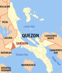 Map of Quezon showing the location of Sariaya | |||||||
.svg.png) Sariaya, Quezon Location within the Philippines | |||||||
| Coordinates: 13°58′N 121°32′E / 13.967°N 121.533°ECoordinates: 13°58′N 121°32′E / 13.967°N 121.533°E | |||||||
| Country | Philippines | ||||||
| Region | CALABARZON (Region IV-A) | ||||||
| Province | Quezon | ||||||
| District | 2nd district of Quezon | ||||||
| Founded | October 4, 1599 (Castañas) | ||||||
| Barangays | 43 | ||||||
| Government | |||||||
| • Mayor | Marcelo P. Gayeta (LP) | ||||||
| • Vice Mayor | Alexander A. Tolentino (LP) | ||||||
| Area[1] | |||||||
| • Municipality | 245.3 km2 (94.7 sq mi) | ||||||
| • Urban | 0.631 km2 (0.244 sq mi) | ||||||
| • Rural | 244.6 km2 (94.4 sq mi) | ||||||
| Area rank | 13th out of 41 in Quezon | ||||||
| Elevation | 1,200 m (3,800 ft) | ||||||
| Population (2015)[2] | |||||||
| • Municipality | 148,980 | ||||||
| • Rank | 2nd out 41 in Quezon | ||||||
| • Density | 610/km2 (1,600/sq mi) | ||||||
| Demonym(s) | Sariayahin | ||||||
| Time zone | PST (UTC+8) | ||||||
| ZIP code | 4322 | ||||||
| Dialing code | 42 | ||||||
| Income class | 1st class municipality | ||||||
| • Total LGU Income |
| ||||||
| • Expenses | PHP 206.07 million (2014) | ||||||
| • Assets | PHP 390.88 million (2014) | ||||||
| • Equity | PHP 152.49 million (2014) | ||||||
| Website |
www | ||||||


Sariaya, officially as the Municipality of Sariaya (Filipino: Bayan ng Sariaya) is a first class municipality located in the province of Quezon, Philippines. Sariaya, being the only Mount Banahaw town in both Quezon and Laguna Provinces that has a sea coast is one of the most visited municipality in Quezon during summer season for its very accessible and numerous beach resorts that offers a pristine beach and also offers a lot of recreational activities. The town is tagged as the Heritage Town of Quezon and Art Deco Capital of Southern Luzon for its extant heritage houses and structures built in Art Deco-styled architecture scattered mostly in the Town Proper and also well-known for its scrumptious delicacies such as Pinagong, Broas, Apas, Leche Puto, Yema and more.
Geography
Sariaya is an inland municipality in the province of Quezon, located 126 kilometers south of the National Capital Region where the country's capital of Manila is situated and approximately 12 kilometers from the highly urbanized city of Lucena. The municipality is bordered by Tayabas City on north-east side, the city of Lucena on its southeast, the municipality of Candelaria on its west, and the town of San Juan in Batangas on its south-west. Mount Banahaw flanks it on the north and Tayabas Bay on the south side.
Barangays
Sariaya has a total land area of 24,530 hectares and composed of 43 barangays. Six (6) barangays are urban barangays located at the Poblacion, one (1) barangay is classified as sub-urban and six (6) barangays are coastal barangays.[1]
Hereunder is the list of Barangays in Municipality of Sariaya and its land area:
| Barangay | Land Area (Ha) | Area Rank | Population (2015)[2] | Classification |
|---|---|---|---|---|
| Antipolo | 490.60 | 27.5 | 1,866 | |
| Balubal | 560.68 | 19 | 5,020 | |
| Bignay 1 | 630.80 | 15 | 4,954 | |
| Bignay 2 | 728.90 | 10 | 3,525 | |
| Bucal | 518.63 | 23.5 | 3,206 | |
| Canda | 588.71 | 18 | 3,214 | |
| Castañas | 876.10 | 8 | 6,113 | |
| Concepcion 1 | 827.00 | 9 | 5,197 | |
| Concepcion Banahaw | 1,345.00 | 2 | 2,878 | |
| Concepcion Palasan | 939.14 | 6 | 6,462 | |
| Concepcion Pinagbakuran | 714.90 | 11 | 2,822 | |
| Gibanga | 546.70 | 21 | 3,460 | |
| Guisguis San Roque | 448.54 | 29.5 | 2,252 | |
| Guisguis Talon | 530.65 | 22 | 3,929 | |
| Janagdong 1 | 518.63 | 23.5 | 3,405 | |
| Janagdong 2 | 672.80 | 12.5 | 2,935 | |
| Limbon | 280.34 | 36 | 1,357 | |
| Lutucan 1 | 392.50 | 34 | 4,602 | |
| Lutucan Bata | 490.60 | 27.5 | 2,200 | |
| Lutucan Malabag | 497.60 | 26 | 4,218 | |
| Mamala 1 | 441.07 | 32 | 2,932 | |
| Mamala 2 | 442.00 | 31 | 5,727 | |
| Manggalang 1 | 1,198.43 | 3 | 6,893 | |
| Manggalang Bantilan | 672.80 | 12.5 | 3,750 | |
| Manggalang Kiling | 616.85 | 17 | 2,649 | |
| Manggalang Tulo-Tulo | 623.80 | 16 | 3,112 | |
| Montecillo | 658.79 | 14 | 4,147 | |
| Morong | 434.53 | 33 | 1,833 | |
| Pili | 448.54 | 29.5 | 3,949 | |
| Poblacion 1 | 8.5 | 40 | 1,806 | |
| Poblacion 2 | 14.5 | 39 | 1,380 | |
| Poblacion 3 | 7.0 | 42 | 1,108 | |
| Poblacion 4 | 16.60 | 38 | 3,386 | |
| Poblacion 5 | 7.5 | 41 | 1,258 | |
| Poblacion 6 | 6.0 | 43 | 1,200 | |
| Sampaloc 1 | 1,037.26 | 4 | 2,608 | |
| Sampaloc 2 | 1,023.24 | 5 | 6,113 | |
| Sampaloc Bogon | 1,675.03 | 1 | 1,035 | |
| Santo Cristo | 911.11 | 7 | 8,953 | |
| Talaan Aplaya | 553.67 | 20 | 2,980 | |
| Talaan Pantoc | 273.33 | 37 | 2,185 | |
| Tumbaga 1 | 518.63 | 23.5 | 4,425 | |
| Tumbaga 2 | 336.41 | 35 | 1,936 |
Topography

Sariaya is situated on a flat land except for a portion on the north occupying a part of the foot of Mount Banahaw. The municipality has the highest point of elevation on 3,800 feet above sea level at Barangays Concepcion Banahaw and Sampaloc Bogon.
Climate
Sariaya falls under Type III of the PAGASA’s climatic classification system this is because it is situated on the southern portion of the province's mountain ranges characterized by seasons not very pronounced, relatively dry from December to April and wet during the rest of the year. The maximum rain periods are not very pronounced with the short dry season lasting from two to four months.[3]
| Climate data for Sariaya | |||||||||||||
|---|---|---|---|---|---|---|---|---|---|---|---|---|---|
| Month | Jan | Feb | Mar | Apr | May | Jun | Jul | Aug | Sep | Oct | Nov | Dec | Year |
| Average high °C (°F) | 28 (82) |
28 (82) |
30 (86) |
32 (90) |
32 (90) |
32 (90) |
31 (88) |
31 (88) |
31 (88) |
30 (86) |
29 (84) |
30 (86) |
30.3 (86.7) |
| Average low °C (°F) | 22 (72) |
22 (72) |
23 (73) |
24 (75) |
24 (75) |
24 (75) |
24 (75) |
24 (75) |
23 (73) |
23 (73) |
23 (73) |
23 (73) |
23.3 (73.7) |
| Average rainfall mm (inches) | 92 (3.62) |
55 (2.17) |
46 (1.81) |
62 (2.44) |
117 (4.61) |
184 (7.24) |
211 (8.31) |
211 (8.31) |
233 (9.17) |
320 (12.6) |
323 (12.72) |
263 (10.35) |
2,117 (83.35) |
| Source: World Weather Online[4] | |||||||||||||
Demographics
| Population census of Sariaya | ||
|---|---|---|
| Year | Pop. | ±% p.a. |
| 1990 | 91,081 | — |
| 1995 | 100,709 | +1.90% |
| 2000 | 114,568 | +2.80% |
| 2007 | 128,248 | +1.57% |
| 2010 | 138,894 | +2.94% |
| 2015 | 148,980 | +1.34% |
| Source: Philippine Statistics Authority[2] | ||
According to the 2015 census of population, Sariaya has a total population of 148,980 people.[2] It is the second most populous area in Quezon after the City of Lucena being the highly populated area. The Poblacion is the most populous area in Sariaya with a total population of 10,138 people according to the 2015 census, Barangay Sto. Cristo ranks second and Manggalang 1 placed in the third rank.
Economy
Income
Agriculture is one of the major sources of income in Sariaya and according to the 2016 Competitiveness Index of the National Competitiveness Council or NCC, the municipality belongs to the Top 50 most competitive municipalities in the Philippines.[5] Sariaya is also one of the top grosser municipality in Quezon when it comes to annual income according to the annual Audit Report of Commission on Audit (COA).
Here's the list of the total annual income, assets, expenses and equity of Sariaya since 2008:
| Year | Total Income (COA).[6] | Assets" | Expenses | Equity |
|---|---|---|---|---|
| 2008 | ₱139.37 million | ₱141.48 million | ₱112.92 million | ₱101.17 million |
| 2009 | ₱154.89 million | ₱198.33 million | ₱141.55 million | ₱109.66 million |
| 2010 | ₱164.55 million | ₱202.63 million | ₱158.44 million | ₱101.71 million |
| 2011 | ₱183.43 million | ₱243.13 million | ₱172.08 million | ₱106.77 million |
| 2012 | ₱183.59 million | ₱237.29 | ₱181.60 million | ₱112.67 million |
| 2013 | ₱212.08 million | ₱239.29 million | ₱200.54 million | ₱117.99 million |
| 2014 | ₱243.73 million | ₱390.88 million | ₱206.07 million | ₱152.49 million |
Commerce


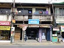
The trade and commerce in Sariaya is heavily concentrated in General Luna Street which is the town's central business district where majority of the town's commercial establishments are situated such as retail, supermarkets, banks, drugstores, bakeries, merchandising, grocery, hardware, fastfood chains, shopping center, convenience stores and others.
Infrastracture
Transportation
Bus

The municipality is traversed by the Pan-Philippine Highway and Provincial Buses and buses from Metro Manila and Lucena City such as JAC Liner Inc., DLTBCO, JAM Liner, Lucena Lines, LLI Inc., BALGCO and Supreme stops at the town's designated bus stop located in Palmas Verdes Subdivision in Brgy. Concepcion 1, Sambat-Lutucan Bus stop in Brgy. Sto. Cristo, Jollibee Sariaya Terminal in Brgy. Poblacion 4 and in the front of the Public Market in Brgy. Poblacion 3 for passengers.
Jeepney
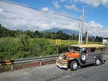
There are also Jeepney Terminals located in the Town Proper. For passengers going to Lucena City, the terminal is located in the front of Jollibee Sariaya Branch in General Luna Street and for the passengers going to Candelaria and Tayabas City, the terminal is located in front of Sariaya Public Market also in General Luna Street.
Tricycle

Tricycle is the most common mode of transportation in the Municipality of Sariaya. There are lots of tricycle terminals in Poblacion, some are located in Quezon Avenue, Magdami Street and mostly in the public market serving the local commuters to the nearby barangays of the town.
Hospitals

There are two (2) hospitals in Sariaya, both are private and there's also a health center for free health services in the forty-three (43) barangays of the municipality.
- Greg Hospital, located at General Luna St., Brgy. Poblacion 1
- Soler General Hospital, located at Mabini St., Brgy. Poblacion 6
Communication
Sariaya is served by landline and mobile phone companies like the General Telephone System, Inc. (GTSi) and Digitel Telecommunications (PLDT-Digitel) as the main telecommunication services providers in the municipality. Major mobile phone providers in the area includes Globe Telecom, Smart Communications, and Sun Cellular. Also, Sariaya has a cable provider which is the Sariaya Cable Network founded in 1993.
Festivities
Celebrated every15th day of May, this religious festivity pays tribute to San Isidro Labrador, the patron saint of farmers. This much-anticipated feast is almost similar to the "Pahiyas Festival" of Lucban, Quezon. Pliant bamboo treetops and trellises weighed down by hanging food treats, native candies, rice cakes, and colorful rice krispies called "kiping" are deliberately pulled down on the streets by the merrymakers right after the afternoon procession. Festival revelers from the town's barangays, neighboring towns, and other provinces would then scramble to gather as many treats as they can snatch and carry, hence the term "Agawan."
- Annual Town Fiesta

Celebrated every 14th day September in honor to Santo Cristo de Burgos. People from far-flung barangays flock to town to attend the fiesta Mass, sell their farm products and handicrafts in the public market, visit the gaudily-decorated and crowded venue for the annual "perya" (fiesta fair) for thrilling rides, occasional circus performances, and shows featuring human mutants, trained animals performing tricks, vendors peddling herbal medicines, and "peryantes," itinerant peddlers of cheap clothing, toys, and kitchen utensils. Basketball tournaments usually stage the championship game on the eve of this much-awaited day. Sometimes there are hired stage performances at the town plaza that feature national stage and film celebrities.
- Belen Festival
Celebrated every 15th day December. to commemorate the birth of the Infant Jesus, many families and local institutions display their Christmas creches variously and creatively decorated to signify the scene, atmosphere, and characters of the Messiah's birth, either using clay, plaster, or ceramic models, and sometimes incorporating human reenactors.
Places of Interest
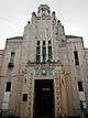
Saint Francis of Assisi Parish Church
.jpg)
Saint Francis of Assisi Parish Church is a stone church built in 1748, located at Brgy. Poblacion II. Records tell that the present church is the fifth one erected by the Spanish Franciscan Friars in the history of Sariaya. In 1938, a historical marker bearing a brief history of the church was installed on its facade by the National Research and Markers Committee, precursor of the National Historical Commission of the Philippines.[7]
Tumbaga Church Ruins

Remains of an early 18th-century stone church and former town site of Sariaya, located at Brgy. Tumbaga I. The settlement was inaugurated in 1703 with Father Lucas Fernandez as first parish priest and Francisco Argente as Presidente del Pueblo. The church, which measured 500 square meters, served a recorded population of 3000 parishioners. Two events led to the abandonment of the town site: the earthquake of 1743 which consequently destroyed the church's bell tower, and the Moro raids which left the town site in ruins after being razed by fire. The venerated image of Santo Cristo de Burgos is said to have been enshrined in the church before it was transferred to its present shrine in the San Francisco Church in the present-day town proper of Sariaya. The unscathed image was said have been retrieved from the burnt church after the Muslim raider attack. The church is believed to be the fourth church structure built by the Spanish Franciscan Friars in Sariaya.[8]
Sariaya Park
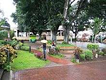
This multi-purpose park is a perfect place for recreational activities because of its pleasant and calm ambiance where kids can play at the park's playground, located at the heart of the town in front of Sariaya Church and the Town Hall at the left side. Sariaya Park is also the location where Sariaya Sports Complex is situated and usually used as the venue of different events and Basketball Leagues in the town.
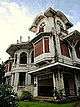
Sariaya Heritage Houses


On May 14, 2008, the National Historical Institute (NHI) unveiled markers of heritage houses for the three ancient yet still stately mansions at the heart of Sariaya town. These venerable houses are best viewed from the south, as they are silhouetted against the majestic and mystical Mount Banahaw, Quezon's long-dormant volcano. Cultural recognition was bestowed on three ancestral houses, namely: The Enriquez-Gala mansion, owned by former Tayabas (now Quezon) Gov. Natalio Enriquez and Susana Gala; the Gala-Rodriguez house of Dr. Isidro Rodriguez and Gregoria Gala, and the house of Catalino and Luisa Rodriguez also known as Villa Sariaya.[9]
Beach Resorts
The municipality is the only Mount Banahaw town in both Laguna and Quezon provinces that has a sea coast that is why it is one of the most visited municipality in Quezon by the tourists coming from Metro Manila, Laguna and nearby towns during summer season for its very accessible beach resorts that offers pristine beach stretched in Tayabas Bay. Aside of beach resorts, the town have also Pool Resorts that can be found in Barangays of Balubal, Gibanga, Concepcion 1 and Castañas.
Pool & Beach Resorts
- Montevista Beach Resort
- Dalampasigan Beach Resort
- Paraiso Beach Resort
- Villa del Prado Beach Resort
- Christian's Beach Resort
- Marina Azul Beach Resort
- Beachwood Beach Resort
- Baywatch Beach Resort
Pool Resorts
- Balai Sadyaya Resort
- Villa Leandro Resort
- Lucky D Resort
- Lynelle's Lagoon Resort
- Oyayi Farm and Resort
- Ada's Resort and Spa
Beach Resorts with Boat Rides to Coral Reefs
- Triple J Beach Resort (Brgy. Guis-Guis Talon)
- M.Y. Beach Resort (Brgy. Guis-Guis Talon)
Local Government
Government Officials

The 2016 local elections in Sariaya was held on May 9, 2016 and some members of the municipal government was replaced, including the mayor, vice mayor and other members of the municipal council. Elected officials for the 2016-2019 term are:
| Position | Name |
|---|---|
| Mayor | Marcelo P. Gayeta |
| Vice-Mayor | Alexander A. Tolentino |
| Councilors | Teoderico C. dela Peña |
| Leonardo S. dela Roca | |
| Aristeo M. Ilao | |
| Daisy V. Quiminiano | |
| Ofelia C. Villapando | |
| Julio C. de Leon | |
| Jefferson E. Albis | |
| Demia P. Maghirang |
Congressional District
The Municipality of Sariaya belongs to the 2nd District of Quezon, located in the western part of the province together with the municipalities of San Antonio, Dolores, Tiaong, Candelaria and the City of Lucena.The Second District is the most populous in the four districts in the Province of Quezon with a total population of 694,732 people according to the 2015 census of population and almost ⅓ of the province's total population.
| City/Municipality | District | Income Class | Land Area | Population (2015) |
|---|---|---|---|---|
 Lucena City Lucena City | 2nd | Highly Urbanized | 80.21 km² (30.97 sq mi) | 266,248 |
 Candelaria Candelaria | 2nd | 1st class | 129.10 km² (49.85 sq mi) | 117,434 |
 Dolores Dolores | 2nd | 4th class | 60.35 km² (23.30 sq mi) | 28,891 |
 San Antonio San Antonio | 2nd | 3rd class | 172.93 km² (66.77 sq mi) | 33,467 |
 Sariaya Sariaya | 2nd | 1st class | 245.3 km² (94.7 sq mi) | 148,980 |
 Tiaong Tiaong | 2nd | 1st class | 168.38 km² (65.01 sq mi) | 99,712 |
Education


| Level | School |
|---|---|
| Tertiary | Computer Systems Technological College Inc. |
| Colegio de Santo Cristo de Burgos | |
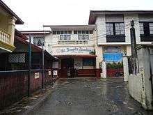
| Secondary | Sariaya Institute (private non-sectarian) |
| St. Joseph's Academy of Sariaya, Quezon (private sectarian) | |
| St. Francis High School (private sectarian) | |
| Lutucan National High School (public) | |
| Canda National High School (public) | |
| Sariaya National High School (public) | |
| Pili National High School (public) | |
| Janagdong National High School (public) | |
| Primary | Sariaya East Central Main Elementary School |
| Manuel L. Quezon Elementary School | |
| Jose Rizal Elementary School | |
| Mamala Elementary School | |
| Balubal Elementary School | |
| Sampaloc Elementary School | |
| Concepcion Elementary School | |
| Governor Natalio and Susana Enriquez Elementary School | |
| Pantoc Elementary School | |
| Talaan Elementary School | |
| Morong Elementary School | |
| Manggalang Elementary School | |
| Concepcion Ibaba Elementary School | |
| Concepcion Pinagbakuran Elementary School | |
| Lutucan Bata Elementary School | |
| Concepcion Banahaw Elementary School | |
| Tulo-Tulo Elementary School | |
| Castañas Elementary School | |
| Lutucan Adventist Elementary School | |
| Sariaya Conservative Baptist Christian School Inc. | |
| Holy Spirit Learning Center | |
| St. Therese of the Child Jesus Learning Center |
Notable Persons
- Leo Austria — former professional basketball player and the head coach of San Miguel Beermen of the Philippine Basketball Association.
- Maximo Rodriguez — twice Sariaya Municipal President (Mayor) from 1906-1907 and 1914-1916 and twice Tayabas (Quezon) Provincial Governor from 1916-1922 and 1933-1937. He also became the principal sponsor of former Philippine president Manuel L. Quezon and Aurora Aragon at their Hongkong wedding and he was also the instrument in the peaceful surrender of the dreaded Kapitan Kulas and became the Chairman-General Manager of the National Coconut Corporation (NACOCO), the fore runner of the Philippine Coconut Authority. He established the Maximo Rodriguez Solid Laboratory in Sariaya.
- Braulio de Villa — twice Sariaya Town Gobernadorcillo (Mayor) in 1889 and 1892 to 1894, and later became the Provincial Governor of Batangas, his home province.
- Natalio Enriquez – Sariaya Municipal President (Mayor) from 1938 to1940 and later became the Provincial Governor of Tayabas (Quezon Province) from 1941 to1945.
- Jovencio de Villa – became the Provincial Governor of Tayabas Province (Quezon Province) during the Japanese Occupation period.
- Roberto P. Racelis – was elected as Provincial Vice Governor of Quezon Province thrice but became Governor (by Operation of Law) from August 8, 1995 to July 25, 1996, and from April 4, 1998 to June 30, 1998.
Sister Cities
References
- 1 2 "Province: QUEZON". PSGC Interactive. Makati City, Philippines: National Statistical Coordination Board. Retrieved 27 November 2013.
- 1 2 3 4 "Highlights of the Philippine Population 2015 Census of Population". 2015 Census of Population and Housing. Philippine Statistics Office. Retrieved 27 May 2016.
- ↑ "Climate of Sariaya". Mount Banahaw.
- ↑ "Average High/Low Temperature for Sariaya, Quezon, Philippines". World Weather Online. Retrieved 2 July 2016.
- ↑ "Competitiveness Index". National Competitiveness Council.
- ↑ "2014 COA Annual Financial Report for Local Government Unit". "Commission on Audit.
- ↑ "Sariaya Church". Waypoints".
- ↑ San Jose-Valdoria, Nancy (November–December 2001). "Tumbaga: Unang "Pueblo", 1703-1743". Sariaya Community Magazine. 2 (7): 20–22.
- ↑ Mallari Jr., Delfin. "History lives in Sariaya mansions". Philippine daily Inquirer. Retrieved May 14, 2013.
- ↑ "Elected Officials of Sariaya". iVotePH.
External links
| Wikimedia Commons has media related to Sariaya. |
 |
Mount Banahaw | | ||
| Candelaria | |
Tayabas Lucena | ||
| ||||
| | ||||
| San Juan, Batangas | Tayabas Bay |
Lucena (capital) | |
| Municipalities |
|
| Component city | |
| Highly urbanized city |
|