Provincial Highway 4 (Taiwan)
| ||||
|---|---|---|---|---|
 | ||||
| Route information | ||||
| Maintained by Directorate General of Highways | ||||
| Length: | 39.297 km[1] (24.418 mi) | |||
| Major junctions | ||||
| West end: |
| |||
| East end: |
| |||
| Highway system | ||||
| ||||

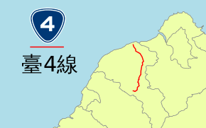
Provincial Highway 4 (Chinese: 台4線) is a provincial highway that runs from Dayuan to Longtan in Taoyuan City.
Route Description
Highway 4 begins at the junction of PH 15 in Dayuan, near Taiwan Taoyuan International Airport. The highway then continues through Luzhu, and is one of the main roads in Nankan (南崁) area, one of the fastest-growing suburbs in Taoyuan City. After the intersection with Freeway 1, the road enters Central Taoyuan as Chunri Road (春日路). The road then runs concurrently with PH 1 as Sanmin Road (三民路) in downtown Taoyuan until PH 1 splits and becomes Zhonghua Road (中華路). Highway 4 continues as Sanmin Road until it reaches Bade, where it becomes Jieshou Road (介壽路) and crosses Freeway 2. The road then enters the suburban district of Daxi, where it runs concurrent with PH 3 before splitting near old town Daxi. The highway continues and ends at the north rim of Shimen Dam in Longtan.
Major intersections
| County | Location | km[2] | mi | Destinations | Notes |
|---|---|---|---|---|---|
| Dayuan | 0.0 | 0.0 | Access to PH 15 southbound / from PH 15 northbound only | ||
| 0.17 | 0.11 | ||||
| 3.6 | 2.2 | TR 5 north (Kengguo Road) – Haihu | |||
| Luzhu | 5.3 | 3.3 | TR 19 south (Bagu Road) – Dapojiao | ||
| 5.7 | 3.5 | TR 15 south (Section 3, Fuguo Road) – Luzhu | |||
| 6.7 | 4.2 | ||||
| 8.6 | 5.3 | TR 3 north (Section 1, Nanshan Road) – Shanjiao | No access to TR 3 from PH 4 eastbound | ||
| 8.8 | 5.5 | TR 6 west (Section 1, Nanzhu Road) – Dazhu | |||
| 10.0 | 6.2 | Exit 49 (Taoyuan Interchange) on Fwy. 1 | |||
| Taoyuan District | 11.5 | 7.1 | TR 18 west (Zhuangjing Road) | ||
| 14.5 | 9.0 | West end of PH 1 / CR 110 concurrency | |||
| 15.5 | 9.6 | East end of CR 110 concurrency | |||
| 16.0 | 9.9 | East end of PH 1 concurrency | |||
| 16.4 | 10.2 | ||||
| 17.5 | 10.9 | TR 55 south (Jiexin Street) | |||
| Bade | 20.0 | 12.4 | TR 48 west (Guangfu Road) – Zhongli | ||
| 20.1 | 12.5 | ||||
| 23.0 | 14.3 | ||||
| Daxi | 25.1 | 15.6 | TR 56 south (Lane 555, Jieshou Road) | ||
| 27.0 | 16.8 | West end of PH 3 concurrency | |||
| 28.2 | 17.5 | TR 64 west (Sanyuan 1st Road) | East end of PH 3 concurrency | ||
| 32.8 | 20.4 | TR 59-1 south – Cihu | |||
| Longtan | 39.4 | 24.5 | |||
1.000 mi = 1.609 km; 1.000 km = 0.621 mi
| |||||
See also
 Taiwan portal
 Roads portal
References
- ↑ "Provincial Highway Mileage Table". Directorate General of Highways. Retrieved 19 May 2014.
- ↑ Google (26 April 2014). "Overview Map of Provincial Highway 4" (Map). Google Maps. Google. Retrieved 26 April 2014.
External links
 Media related to Provincial Highway 4 (Taiwan) at Wikimedia Commons
Provincial Highways of Taiwan | ||
|---|---|---|