Provincial Highway 64 (Taiwan)
| ||||
|---|---|---|---|---|
|
東西向快速公路八里新店線 (East-West Expressway, Bali-Xindian Line) | ||||
 | ||||
| Route information | ||||
| Maintained by Directorate General of Highways | ||||
| Length: | 28.390 km[1] (17.641 mi) | |||
| Existed: | January 31st, 2000 – present | |||
| Major junctions | ||||
| West end: |
| |||
|
| ||||
| East end: |
| |||
| Highway system | ||||
| ||||

Provincial Highway 64 (台64線, PH 64) is a 28.390-kilometre-long (17.641-mile) expressway in Taiwan entirely within the limits of New Taipei City. Also known as East-West Expressway, Bali-Xindian Line (Chinese: 東西向快速公路八里新店線; Hanyu Pinyin: Dōngxīxiàng Kuàisùgōnglù Bālǐ Xīndiàn Xiàn; Tongyong Pinyin: Dongsisiàng Kuàisùgonglù Balǐ Sindiàn Siàn), the route begins in Port of Taipei in Bali District and ends near the west approach of Xiulang Bridge in Zhonghe District, linking many major population centers within New Taipei together, including Sanchong, Banqiao, and Zhonghe. It is one of the twelve east-west expressways of western Taiwan linking Freeways 1 and 3.
Route description
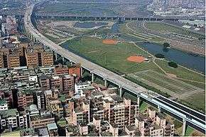
As an elevated expressway, PH 64 traverses through rural, suburban, and urban areas of New Taipei City. Beginning near Port of Taipei in Bali District, the route proceeds southwest, crossing over PH 15 and CR 105. Then the route turns south and tunnels through Guanyin Mountain with Guanyinshan Tunnel. The route emerges from the tunnel near the Chengzilao area of Wugu District, turning southwest along the west shore of Erchong Flood Diversion Path (二重疏洪道). PH 64 then intersects with CR 108, with an indirect connection to Freeway 1 available via a viaduct over CR 108 and CR 107A at this interchange. Then the expressway crosses over Freeway 1 and leaves Wugu.
As the route enters Sanchong, it leaves the rural areas of the city and takes on a more suburban character. PH 64 continues southeast along Erchong Flood Diversion Path, and then crosses over Dahan River with New Taipei Expressway on Chongcui Bridge as it exits Sanchong and enters Banqiao. The route proceeds southwest, straddling the south shore of Dahan River before turning southeast near CR 106A and Dahan Bridge into central Banqiao. Here the expressway enters the urban areas of New Taipei, with tall buildings closely lining the sides of the expressway, and proceeds like this until the eastern terminus.
The expressway continues above CR 106A, which is Minsheng Road in Banqiao, and becomes Zhongzheng Road in Zhonghe. At the interchange with Freeway 3 in Zhonghe, the route bends from south to east. It then continues above Zhongzheng Road (CR 106A) and then Jingping Road (CR 106) in Zhonghe before terminating near the western approach of Xiulang Bridge. The route does not actually reach Xindian; to get there, it is necessary to use Xiulang Bridge, which is actually CR 106 and not PH 64.[2]
History
The road was originally planned as a mostly at-grade boulevard by Taipei County Government named Special Route 1 (特一號道路) from Xiulang Bridge in Zhonghe to Wugu Industrial Park (now New Taipei Industrial Park) through Banqiao and Xinzhuang. Originally the only elevated section of the route was from Dahan Bridge to Minsheng Overpass in Banqiao. In the 1990s, as part of the expressway plans in Taiwan, the Special Route 1 corridor was selected to be upgraded to an expressway-grade Provincial Highway as PH 64. However, due to highway revolts from residents of Xinzhuang and central Wugu, the western portion of PH 64 was realigned to the present route, which bypassed the controversial areas by using the right-of-way near the levees and terminated at Taipei Port in Bali instead of Wugu Industrial Park.
The road opened in stages, and was completed by late 2009. The section from Banqiao to Zhonghe opened in 2000, while the section from Banqiao to Bali opened in 2009. Just before the section from Banqiao to Bali opened, the completed expressway was used to host a “car-free” event.[3] Bicyclists and pedestrians had exclusive use of the expressway, and some celebratory events took place to celebrate the completion of PH 64.[4]
Exit list
The entire route is in New Taipei City.
| Location | km[1] | mi | Exit | Name | Destinations | Notes | |
|---|---|---|---|---|---|---|---|
| Bali | 0.000 | 0.000 | — | ||||
| 0.855 | 0.531 | 1 | Bali | Westbound exit and eastbound entrance | |||
| Mount Guanyin | 2.6– 5.2[5] | 1.6– 3.2 | Guanyinshan Tunnel | ||||
| Wugu | 6.474 | 4.023 | 6 | Guanyinshan | |||
| 10.200 | 6.338 | 10 | Wugu 1 | Chengzilao | |||
| 11.823 | 7.346 | 11 | Wugu 2 | ||||
| Sanchong | 15.028 | 9.338 | 14 16 | Sanchong | Signed as exit 14 eastbound and exit 16 westbound | ||
| Banqiao | 17.823 | 11.075 | 17 | Jiangzicui | New Taipei Expressway | Eastbound exit and westbound entrance | |
| 18 | Huanhe Road – Jiangzicui | Westbound exit and eastbound entrance | |||||
| 20.880 | 12.974 | 20 | Banqiao | ||||
| Zhonghe | 23.020 | 14.304 | 23 | Zhonghe 1 | Eastbound exit and westbound entrance | ||
| 23.886 | 14.842 | 24 | Zhonghe | Eastbound exit and westbound entrance | |||
| 26.603 | 16.530 | 26 | Zhonghe 2 | Yuantong Road – Zhonghe | Eastbound exit and westbound entrance | ||
| 28.390 | 17.641 | — | |||||
| 1.000 mi = 1.609 km; 1.000 km = 0.621 mi | |||||||
See also
References
- 1 2 "省道公路里程表 (Expressway mileage chart)" (XLS file) (in Chinese). Directorate General of Highways, MOTC. Retrieved 15 March 2014.
- ↑ "八里新店線(台64線)工程成果簡介 (PH 64 Project Overview)" (in Chinese). Construction and Planning agency, Ministry of the Interior (Taiwan) (內政部營建署). 9 September 2008. Retrieved 12 February 2013.
- ↑ 大台北國際無車日 台64線實施交通管制 (in Chinese). The Epoch Times. 16 September 2009. Retrieved 12 February 2013.
- ↑ "Cyclists hit the road to celebrate Carfree Day in Taipei City". 20 September 2009. Retrieved 12 February 2013.
- ↑ Google (15 March 2014). "Guanyinshan Tunnel" (Map). Google Maps. Google. Retrieved 15 March 2014.
External links
| Freeways |
| |||||||
|---|---|---|---|---|---|---|---|---|
| Provincial Highways |
| |||||||
Provincial Highways of Taiwan | ||
|---|---|---|