Prim, Arkansas
| Prim, Arkansas | |
|---|---|
| Unincorporated community | |
| Motto: Home of the Round Rocks! | |
 Prim, Arkansas  Prim, Arkansas | |
| Coordinates: 35°41′38″N 92°06′31″W / 35.69389°N 92.10861°WCoordinates: 35°41′38″N 92°06′31″W / 35.69389°N 92.10861°W | |
| Country | United States |
| State | Arkansas |
| County | Cleburne |
| Elevation | 1,214 ft (370 m) |
| Time zone | Central (CST) (UTC-6) |
| • Summer (DST) | CDT (UTC-5) |
| ZIP code | 72130 |
| Area code(s) | 870 |
| GNIS feature ID | 53799[1] |
Prim is an unincorporated community in Cleburne County, Arkansas, United States. Prim is located at the junction of Arkansas Highway 225 and Arkansas Highway 263 9 miles (14 km) north-northeast of Greers Ferry. Prim has a post office with ZIP code 72130.[2]
Education
Public education for elementary and secondary students is provided by West Side School District, West Side Elementary School and West Side High School located in Greers Ferry. The district encompasses more than 147.81 square miles (382.8 km2) of land that includes all or portions of Cleburne County and Van Buren County communities including: Higden, Bee Branch, Quitman, Heber Springs, Prim, Edgemont, Shirley, Fairfield Bay, Greers Ferry, and Drasco. There is also a private school, Hilltop Holiness Academy. This is owned and operated by Hilltop Holiness Church. The Board members are John Henegar, BJ Knapp, and Sam Henegar.
References
Municipalities and communities of Cleburne County, Arkansas, United States | ||
|---|---|---|
| Cities | 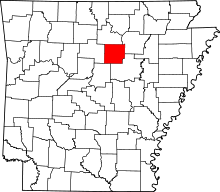 | |
| Towns | ||
| CDP | ||
| Unincorporated communities | ||
| Footnotes | ‡This populated place also has portions in an adjacent county or counties | |